![](/images/other/stat-length.png)
![Excursión Bici de montaña Bélis - Belis a Lencouacq - Photo](https://media.geolcdn.com/t/1900/400/ext.pjpeg?maxdim=2&url=https%3A%2F%2Fstatic1.geolcdn.com%2Fsiteimages%2Fupload%2Ffiles%2F1524743154velo.jpg)
Belis a Lencouacq
plavengut
Usuario
![Longitud](/images/other/stat-length.png)
Longitud
16,8 km
![Altitud máxima](https://static1.geolcdn.com/siteimages/upload/files/1508320355ic_sort_altitude_max_24dp.png)
Altitud máxima
120 m
![Desnivel positivo](https://static1.geolcdn.com/siteimages/upload/files/1508320355ic_sort_den_pos_24dp.png)
Desnivel positivo
166 m
![Km-Effort](/images/other/stat-length.png)
Km-Effort
19 km
![Altitud mínima](https://static1.geolcdn.com/siteimages/upload/files/1508320355ic_sort_altitude_min_24dp.png)
Altitud mínima
77 m
![Desnivel negativo](https://static1.geolcdn.com/siteimages/upload/files/1508320355ic_sort_den_neg_24dp.png)
Desnivel negativo
158 m
![Boucle](https://static1.geolcdn.com/siteimages/upload/files/16400158638029165_repeat_loop_refresh_sync_direction_icon.png)
Boucle
No
Fecha de creación :
2017-05-22 00:00:00.0
Última modificación :
2017-05-22 00:00:00.0
![Bici de montaña](https://static1.geolcdn.com/sitytour/trail-icons/202.png)
1h16
Dificultad : Desconocido
![Escanee este código QR para abrir la excursión en la aplicación SityTrail](https://capi.geolives.com/qq0zvz2zws4bq2lad0pu/sitytour/trails/757696/qr.png?size=200)
Aplicación GPS de excursión GRATIS
A propósito
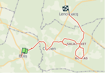
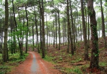
Ruta Bici de montaña de 16,8 km a descubrir en Nueva Aquitania, Landas, Bélis. Esta ruta ha sido propuesta por plavengut.
Descripción
Par des petites routes et des pistes forestières découvertes des petits villages du Parc, de beaux airial; Eglise de Guinas
Localización
País:
France
Región :
Nueva Aquitania
Departamento/provincia :
Landas
Municipio :
Bélis
Localidad:
Unknown
Salida:(Dec)
Salida:(UTM)
703213 ; 4882015 (30T) N.
Comentarios
Excursiones cerca
![Excursión Bicicleta híbrida Le Frêche - le freche Mont de Marsan - Photo](https://media.geolcdn.com/t/375/260/b1ca82d7-7be6-4db0-a13f-2bc75a5bb968.jpg&format=jpg&maxdim=2)
![Bicicleta híbrida Bicicleta híbrida](https://static1.geolcdn.com/sitytour/trail-icons/203.png)
le freche Mont de Marsan
Bicicleta híbrida
Fácil
Le Frêche,
Nueva Aquitania,
Landas,
France
![](/images/other/stat-length.png)
50 km | 57 km-effort
3h 22min
![](https://static1.geolcdn.com/siteimages/upload/files/16400158638029165_repeat_loop_refresh_sync_direction_icon.png)
Sí
![Excursión Senderismo Gaillères - Gaillères 2020 - Photo](https://media.geolcdn.com/t/375/260/ext.jpg?maxdim=2&url=https%3A%2F%2Fstatic1.geolcdn.com%2Fsiteimages%2Fupload%2Ffiles%2F1553511878bg_sport_marche.png)
![Senderismo Senderismo](https://static1.geolcdn.com/sitytour/trail-icons/101.png)
Gaillères 2020
Senderismo
Muy fácil
(1)
Gaillères,
Nueva Aquitania,
Landas,
France
![](/images/other/stat-length.png)
7,2 km | 8,1 km-effort
1h 44min
![](https://static1.geolcdn.com/siteimages/upload/files/16400158638029165_repeat_loop_refresh_sync_direction_icon.png)
Sí
![Excursión Senderismo Arthez-d'Armagnac - arthez d'Armagnac, circuit d'ognias - Photo](https://media.geolcdn.com/t/375/260/5c24c389-4b2e-42df-82c1-d090e8b58cd7.jpg&format=jpg&maxdim=2)
![Senderismo Senderismo](https://static1.geolcdn.com/sitytour/trail-icons/101.png)
arthez d'Armagnac, circuit d'ognias
Senderismo
Medio
Arthez-d'Armagnac,
Nueva Aquitania,
Landas,
France
![](/images/other/stat-length.png)
10,4 km | 12,4 km-effort
2h 53min
![](https://static1.geolcdn.com/siteimages/upload/files/16400158638029165_repeat_loop_refresh_sync_direction_icon.png)
Sí
![Excursión Senderismo Saint-Justin - Saint Justin boucle de l'église de Douzevieille - Photo](https://media.geolcdn.com/t/375/260/5db9b261-5962-497e-bf9d-aa57a6bbf44e.jpg&format=jpg&maxdim=2)
![Senderismo Senderismo](https://static1.geolcdn.com/sitytour/trail-icons/101.png)
Saint Justin boucle de l'église de Douzevieille
Senderismo
Muy fácil
(1)
Saint-Justin,
Nueva Aquitania,
Landas,
France
![](/images/other/stat-length.png)
10,1 km | 11,3 km-effort
2h 16min
![](https://static1.geolcdn.com/siteimages/upload/files/16400158638029165_repeat_loop_refresh_sync_direction_icon.png)
Sí
![Excursión A pie Villeneuve-de-Marsan - Petite Randonnée Villeneuve - Photo](https://media.geolcdn.com/t/375/260/9a1502fb-95da-4a41-b70c-7efd1ad3de51.jpeg&format=jpg&maxdim=2)
![A pie A pie](https://static1.geolcdn.com/sitytour/trail-icons/100.png)
Petite Randonnée Villeneuve
A pie
Fácil
Villeneuve-de-Marsan,
Nueva Aquitania,
Landas,
France
![](/images/other/stat-length.png)
6,1 km | 7,1 km-effort
1h 36min
![](https://static1.geolcdn.com/siteimages/upload/files/16400158638029165_repeat_loop_refresh_sync_direction_icon.png)
Sí
![Excursión Bici de montaña Garein - Garein - Landes de Sindères et de Piat - Photo](https://media.geolcdn.com/t/375/260/ext.jpg?maxdim=2&url=https%3A%2F%2Fservices.sitytrail.com%2FGeolivesWS%2FDownloadMedia.ashx%3FTrailID%3D108997%26Media%3D2935_1.jpg)
![Bici de montaña Bici de montaña](https://static1.geolcdn.com/sitytour/trail-icons/202.png)
Garein - Landes de Sindères et de Piat
Bici de montaña
Medio
Garein,
Nueva Aquitania,
Landas,
France
![](/images/other/stat-length.png)
15,8 km | 17,4 km-effort
1h 19min
![](https://static1.geolcdn.com/siteimages/upload/files/16400158638029165_repeat_loop_refresh_sync_direction_icon.png)
Sí
![Excursión Senderismo Garein - Garein - Landes de Sindères et de Piat - Photo](https://media.geolcdn.com/t/375/260/ext.jpg?maxdim=2&url=https%3A%2F%2Fservices.sitytrail.com%2FGeolivesWS%2FDownloadMedia.ashx%3FTrailID%3D108996%26Media%3D2935_1.jpg)
![Senderismo Senderismo](https://static1.geolcdn.com/sitytour/trail-icons/101.png)
Garein - Landes de Sindères et de Piat
Senderismo
Difícil
(1)
Garein,
Nueva Aquitania,
Landas,
France
![](/images/other/stat-length.png)
15,8 km | 17,4 km-effort
4h 45min
![](https://static1.geolcdn.com/siteimages/upload/files/16400158638029165_repeat_loop_refresh_sync_direction_icon.png)
Sí
![Excursión Bici de montaña Brocas - Brocas - Les Trepèdes - Photo](https://media.geolcdn.com/t/375/260/ext.jpg?maxdim=2&url=https%3A%2F%2Fservices.sitytrail.com%2FGeolivesWS%2FDownloadMedia.ashx%3FTrailID%3D108995%26Media%3D2934_1.jpg)
![Bici de montaña Bici de montaña](https://static1.geolcdn.com/sitytour/trail-icons/202.png)
Brocas - Les Trepèdes
Bici de montaña
Fácil
Brocas,
Nueva Aquitania,
Landas,
France
![](/images/other/stat-length.png)
4,5 km | 5,2 km-effort
19min
![](https://static1.geolcdn.com/siteimages/upload/files/16400158638029165_repeat_loop_refresh_sync_direction_icon.png)
Sí
![Excursión Senderismo Brocas - Brocas - Les Trepèdes - Photo](https://media.geolcdn.com/t/375/260/ext.jpg?maxdim=2&url=https%3A%2F%2Fservices.sitytrail.com%2FGeolivesWS%2FDownloadMedia.ashx%3FTrailID%3D108994%26Media%3D2934_1.jpg)
![Senderismo Senderismo](https://static1.geolcdn.com/sitytour/trail-icons/101.png)
Brocas - Les Trepèdes
Senderismo
Medio
Brocas,
Nueva Aquitania,
Landas,
France
![](/images/other/stat-length.png)
4,5 km | 5,2 km-effort
45min
![](https://static1.geolcdn.com/siteimages/upload/files/16400158638029165_repeat_loop_refresh_sync_direction_icon.png)
Sí