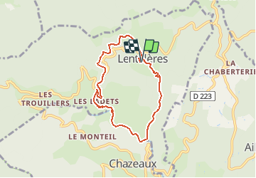
![](/images/other/stat-length.png)
![Excursión Senderismo Lentillères - de la salamandre a la lande - Photo](https://media.geolcdn.com/t/1900/400/ext.pjpeg?maxdim=2&url=https%3A%2F%2Fstatic1.geolcdn.com%2Fsiteimages%2Fupload%2Ffiles%2F1553511878bg_sport_marche.png)
de la salamandre a la lande
Thierry_Garre
Usuario
![Longitud](/images/other/stat-length.png)
![Altitud máxima](https://static1.geolcdn.com/siteimages/upload/files/1508320355ic_sort_altitude_max_24dp.png)
![Desnivel positivo](https://static1.geolcdn.com/siteimages/upload/files/1508320355ic_sort_den_pos_24dp.png)
![Km-Effort](/images/other/stat-length.png)
![Altitud mínima](https://static1.geolcdn.com/siteimages/upload/files/1508320355ic_sort_altitude_min_24dp.png)
![Desnivel negativo](https://static1.geolcdn.com/siteimages/upload/files/1508320355ic_sort_den_neg_24dp.png)
![Boucle](https://static1.geolcdn.com/siteimages/upload/files/16400158638029165_repeat_loop_refresh_sync_direction_icon.png)
![Senderismo](https://static1.geolcdn.com/sitytour/trail-icons/101.png)
2h30
Dificultad : Fácil
![Escanee este código QR para abrir la excursión en la aplicación SityTrail](https://capi.geolives.com/qq0zvz2zws4bq2lad0pu/sitytour/trails/741959/qr.png?size=200)
Aplicación GPS de excursión GRATIS
A propósito
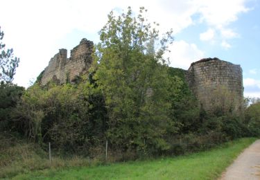
Ruta Senderismo de 6,9 km a descubrir en Auvergne-Rhône-Alpes, Ardecha, Lentillères. Esta ruta ha sido propuesta por Thierry_Garre.
Descripción
-Descendre du hameau des Imberts en direction du sud est
-traverser la piste
longer la rivière vers le sud
au pont romain suivre la rivière sans la traverser.
-rejoindre et suivre la route jusqu'au pont.
-traverser le pont et suivre la rivière jusqu’à une grande prairie (chevaux)
-au bout de la prairie remonter a droite par un chemin jusqu'au Hameau des Ladets.
suivre la route sur la gauche jusqu'au carrefour.
Reprendre à droite la RD335 jusqu'au col de l'Eyrolle.
Au col prendre la route a gauche vers Valsadoul.
prendre le chemin à droite après la cabane des chasseurs.
Suivre le chemin jusqu'au hameau du village.passer sous le porche.
Apres le porche descendre vers les Imberts par un chemin.
Penser a refermer les barrières derrière vous.
Bonne ballade
Puntos de interés
Localización
Comentarios
Excursiones cerca
![Excursión Senderismo Jaujac - Jaujac Le Ventapet 14km - Photo](https://media.geolcdn.com/t/375/260/6a0eb2eb-cf2c-4f85-a155-e7f0aba82db8.jpg&format=jpg&maxdim=2)
![Senderismo Senderismo](https://static1.geolcdn.com/sitytour/trail-icons/101.png)
Senderismo
![](/images/other/stat-length.png)
![](https://static1.geolcdn.com/siteimages/upload/files/16400158638029165_repeat_loop_refresh_sync_direction_icon.png)
![Excursión Senderismo Lentillères - Lentillières_les cretes_les Hameaux-13-02-17 - Photo](https://media.geolcdn.com/t/375/260/b26fd82a-80a8-4147-8d0f-0d41ac6326b3.jpg&format=jpg&maxdim=2)
![Senderismo Senderismo](https://static1.geolcdn.com/sitytour/trail-icons/101.png)
Senderismo
![](/images/other/stat-length.png)
![](https://static1.geolcdn.com/siteimages/upload/files/16400158638029165_repeat_loop_refresh_sync_direction_icon.png)
![Excursión Senderismo Fabras - Fabras - Photo](https://media.geolcdn.com/t/375/260/ext.jpg?maxdim=2&url=https%3A%2F%2Fstatic1.geolcdn.com%2Fsiteimages%2Fupload%2Ffiles%2F1553511878bg_sport_marche.png)
![Senderismo Senderismo](https://static1.geolcdn.com/sitytour/trail-icons/101.png)
Senderismo
![](/images/other/stat-length.png)
![](https://static1.geolcdn.com/siteimages/upload/files/16400158638029165_repeat_loop_refresh_sync_direction_icon.png)
![Excursión Senderismo Jaujac - 07 jaujac rocher de l aigle - Photo](https://media.geolcdn.com/t/375/260/1a765c03-1770-4ba1-9c9c-9314823e934b.jpg&format=jpg&maxdim=2)
![Senderismo Senderismo](https://static1.geolcdn.com/sitytour/trail-icons/101.png)
Senderismo
![](/images/other/stat-length.png)
![](https://static1.geolcdn.com/siteimages/upload/files/16400158638029165_repeat_loop_refresh_sync_direction_icon.png)
![Senderismo Senderismo](https://static1.geolcdn.com/sitytour/trail-icons/101.png)
Senderismo
![](/images/other/stat-length.png)
![](https://static1.geolcdn.com/siteimages/upload/files/16400158638029165_repeat_loop_refresh_sync_direction_icon.png)
![Excursión Senderismo Jaujac - ARDECHE, JAUJAC. .PONT DE L ECHELLE O - Photo](https://media.geolcdn.com/t/375/260/306eb66a-9a51-42c8-b3b4-a2c469fe7bd7.jpg&format=jpg&maxdim=2)
![Senderismo Senderismo](https://static1.geolcdn.com/sitytour/trail-icons/101.png)
Senderismo
![](/images/other/stat-length.png)
![](https://static1.geolcdn.com/siteimages/upload/files/16400158638029165_repeat_loop_refresh_sync_direction_icon.png)
![Excursión Senderismo Jaujac - 07_jaujac_Orgues_9km360m - Photo](https://media.geolcdn.com/t/375/260/944ad327-537f-4f2c-8001-5010f7cb1f7d.jpg&format=jpg&maxdim=2)
![Senderismo Senderismo](https://static1.geolcdn.com/sitytour/trail-icons/101.png)
Senderismo
![](/images/other/stat-length.png)
![](https://static1.geolcdn.com/siteimages/upload/files/16400158638029165_repeat_loop_refresh_sync_direction_icon.png)
![Excursión Senderismo Fabras - Fabras Jaujac les orgues basaltiques - Photo](https://media.geolcdn.com/t/375/260/427a2c6b-ef91-4b91-a4d9-6a96b4534007.jpg&format=jpg&maxdim=2)
![Senderismo Senderismo](https://static1.geolcdn.com/sitytour/trail-icons/101.png)
Senderismo
![](/images/other/stat-length.png)
![](https://static1.geolcdn.com/siteimages/upload/files/16400158638029165_repeat_loop_refresh_sync_direction_icon.png)
![Senderismo Senderismo](https://static1.geolcdn.com/sitytour/trail-icons/101.png)
Senderismo
![](/images/other/stat-length.png)
![](https://static1.geolcdn.com/siteimages/upload/files/16400158638029165_repeat_loop_refresh_sync_direction_icon.png)