![](/images/other/stat-length.png)
![Excursión Senderismo Saint-Joseph - Le tour des pitons Lambert et Papangues - Photo](https://media.geolcdn.com/t/1900/400/ext.pjpeg?maxdim=2&url=https%3A%2F%2Fstatic1.geolcdn.com%2Fsiteimages%2Fupload%2Ffiles%2F1553511878bg_sport_marche.png)
Le tour des pitons Lambert et Papangues
Fdum
Usuario
![Longitud](/images/other/stat-length.png)
Longitud
10,3 km
![Altitud máxima](https://static1.geolcdn.com/siteimages/upload/files/1508320355ic_sort_altitude_max_24dp.png)
Altitud máxima
327 m
![Desnivel positivo](https://static1.geolcdn.com/siteimages/upload/files/1508320355ic_sort_den_pos_24dp.png)
Desnivel positivo
313 m
![Km-Effort](/images/other/stat-length.png)
Km-Effort
14,5 km
![Altitud mínima](https://static1.geolcdn.com/siteimages/upload/files/1508320355ic_sort_altitude_min_24dp.png)
Altitud mínima
50 m
![Desnivel negativo](https://static1.geolcdn.com/siteimages/upload/files/1508320355ic_sort_den_neg_24dp.png)
Desnivel negativo
316 m
![Boucle](https://static1.geolcdn.com/siteimages/upload/files/16400158638029165_repeat_loop_refresh_sync_direction_icon.png)
Boucle
Sí
Fecha de creación :
2017-04-08 00:00:00.0
Última modificación :
2017-04-08 00:00:00.0
![Senderismo](https://static1.geolcdn.com/sitytour/trail-icons/101.png)
2h18
Dificultad : Fácil
![Escanee este código QR para abrir la excursión en la aplicación SityTrail](https://capi.geolives.com/qq0zvz2zws4bq2lad0pu/sitytour/trails/728738/qr.png?size=200)
Aplicación GPS de excursión GRATIS
A propósito
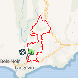
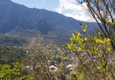
Ruta Senderismo de 10,3 km a descubrir en La Reunión, Desconocido, Saint-Joseph. Esta ruta ha sido propuesta por Fdum.
Descripción
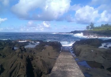
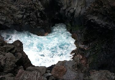
Secteur de LANGEVIN, rando sympa, mais avec beaucoup de bitume. En avril l'herbe est haute dans les chemins de cannes.
Localización
País:
France
Región :
La Reunión
Departamento/provincia :
Desconocido
Municipio :
Saint-Joseph
Localidad:
Unknown
Salida:(Dec)
Salida:(UTM)
360091 ; 7635388 (40K) S.
Comentarios
Excursiones cerca
![Excursión Senderismo Saint-Joseph - Sentier littoral de Langevin - Photo](https://media.geolcdn.com/t/375/260/4a89e685-0071-4c5b-a462-c2b4c9e89e27.jpg&format=jpg&maxdim=2)
![Senderismo Senderismo](https://static1.geolcdn.com/sitytour/trail-icons/101.png)
Sentier littoral de Langevin
Senderismo
Fácil
Saint-Joseph,
La Reunión,
Desconocido,
France
![](/images/other/stat-length.png)
3,4 km | 3,8 km-effort
1h 5min
![](https://static1.geolcdn.com/siteimages/upload/files/16400158638029165_repeat_loop_refresh_sync_direction_icon.png)
Sí
![Excursión Senderismo Saint-Joseph - Cap Jaune randonnée famille - Photo](https://media.geolcdn.com/t/375/260/0eb20c45-f963-4b69-a85f-83e3bdaa6b80.jpg&format=jpg&maxdim=2)
![Senderismo Senderismo](https://static1.geolcdn.com/sitytour/trail-icons/101.png)
Cap Jaune randonnée famille
Senderismo
Muy fácil
Saint-Joseph,
La Reunión,
Desconocido,
France
![](/images/other/stat-length.png)
3,3 km | 4,4 km-effort
2h 0min
![](https://static1.geolcdn.com/siteimages/upload/files/16400158638029165_repeat_loop_refresh_sync_direction_icon.png)
Sí
![Excursión Senderismo Saint-Joseph - La Réunion - Boucle du Piton Babet à Saint-Joseph - Photo](https://media.geolcdn.com/t/375/260/ext.jpg?maxdim=2&url=https%3A%2F%2Fservices.sitytrail.com%2FGeolivesWS%2FDownloadMedia.ashx%3FTrailID%3D452114%26Media%3Dfix__20150726133009.jpg)
![Senderismo Senderismo](https://static1.geolcdn.com/sitytour/trail-icons/101.png)
La Réunion - Boucle du Piton Babet à Saint-Joseph
Senderismo
Muy fácil
(1)
Saint-Joseph,
La Reunión,
Desconocido,
France
![](/images/other/stat-length.png)
3,2 km | 4,7 km-effort
1h 1min
![](https://static1.geolcdn.com/siteimages/upload/files/16400158638029165_repeat_loop_refresh_sync_direction_icon.png)
Sí
![Excursión Senderismo Saint-Joseph - Langevin 18 03 2015 - Photo](https://media.geolcdn.com/t/375/260/ext.jpg?maxdim=2&url=https%3A%2F%2Fservices.sitytrail.com%2FGeolivesWS%2FDownloadMedia.ashx%3FTrailID%3D397342%26Media%3Dfix__20150318100020.jpg)
![Senderismo Senderismo](https://static1.geolcdn.com/sitytour/trail-icons/101.png)
Langevin 18 03 2015
Senderismo
Fácil
Saint-Joseph,
La Reunión,
Desconocido,
France
![](/images/other/stat-length.png)
4,8 km | 5,5 km-effort
3h 2min
![](https://static1.geolcdn.com/siteimages/upload/files/16400158638029165_repeat_loop_refresh_sync_direction_icon.png)
No
![Excursión Senderismo Saint-Joseph - cap jaune - Photo](https://media.geolcdn.com/t/375/260/b1bf09be-09a9-4227-9178-69439bebcf69.jpg&format=jpg&maxdim=2)
![Senderismo Senderismo](https://static1.geolcdn.com/sitytour/trail-icons/101.png)
cap jaune
Senderismo
Muy fácil
Saint-Joseph,
La Reunión,
Desconocido,
France
![](/images/other/stat-length.png)
4,9 km | 6,6 km-effort
1h 18min
![](https://static1.geolcdn.com/siteimages/upload/files/16400158638029165_repeat_loop_refresh_sync_direction_icon.png)
Sí
![Excursión Senderismo Saint-Joseph - boucle cascade bras rouge - Photo](https://media.geolcdn.com/t/375/260/8413d190-b12c-4b8e-9f61-c08c940eceee.jpg&format=jpg&maxdim=2)
![Senderismo Senderismo](https://static1.geolcdn.com/sitytour/trail-icons/101.png)
boucle cascade bras rouge
Senderismo
Difícil
Saint-Joseph,
La Reunión,
Desconocido,
France
![](/images/other/stat-length.png)
61 km | 121 km-effort
10h 8min
![](https://static1.geolcdn.com/siteimages/upload/files/16400158638029165_repeat_loop_refresh_sync_direction_icon.png)
No
![Excursión Bici de montaña Saint-Joseph - st joseph - st Philippe par la route forestière - Photo](https://media.geolcdn.com/t/375/260/ext.jpg?maxdim=2&url=https%3A%2F%2Fstatic1.geolcdn.com%2Fsiteimages%2Fupload%2Ffiles%2F1524743154velo.jpg)
![Bici de montaña Bici de montaña](https://static1.geolcdn.com/sitytour/trail-icons/202.png)
st joseph - st Philippe par la route forestière
Bici de montaña
Medio
Saint-Joseph,
La Reunión,
Desconocido,
France
![](/images/other/stat-length.png)
42 km | 57 km-effort
4h 30min
![](https://static1.geolcdn.com/siteimages/upload/files/16400158638029165_repeat_loop_refresh_sync_direction_icon.png)
No
![Excursión Senderismo Saint-Joseph - A/R Terre rouge, Le récif - Photo](https://media.geolcdn.com/t/375/260/ext.jpg?maxdim=2&url=https%3A%2F%2Fstatic1.geolcdn.com%2Fsiteimages%2Fupload%2Ffiles%2F1553511878bg_sport_marche.png)
![Senderismo Senderismo](https://static1.geolcdn.com/sitytour/trail-icons/101.png)
A/R Terre rouge, Le récif
Senderismo
Muy fácil
Saint-Joseph,
La Reunión,
Desconocido,
France
![](/images/other/stat-length.png)
5 km | 6,8 km-effort
1h 33min
![](https://static1.geolcdn.com/siteimages/upload/files/16400158638029165_repeat_loop_refresh_sync_direction_icon.png)
Sí
![Excursión Senderismo Saint-Joseph - piton vincendo - cap poisson d'ail - Photo](https://media.geolcdn.com/t/375/260/ext.jpg?maxdim=2&url=https%3A%2F%2Fstatic1.geolcdn.com%2Fsiteimages%2Fupload%2Ffiles%2F1553511878bg_sport_marche.png)
![Senderismo Senderismo](https://static1.geolcdn.com/sitytour/trail-icons/101.png)
piton vincendo - cap poisson d'ail
Senderismo
Fácil
Saint-Joseph,
La Reunión,
Desconocido,
France
![](/images/other/stat-length.png)
5,3 km | 7,2 km-effort
1h 30min
![](https://static1.geolcdn.com/siteimages/upload/files/16400158638029165_repeat_loop_refresh_sync_direction_icon.png)
Sí