![](/images/other/stat-length.png)
![Excursión Senderismo Sainte-Opportune-la-Mare - St.Opportune -la-Mare (121) - Photo](https://media.geolcdn.com/t/1900/400/ext.pjpeg?maxdim=2&url=https%3A%2F%2Fstatic1.geolcdn.com%2Fsiteimages%2Fupload%2Ffiles%2F1553511878bg_sport_marche.png)
St.Opportune -la-Mare (121)
randovivi
Usuario
![Longitud](/images/other/stat-length.png)
Longitud
10 km
![Altitud máxima](https://static1.geolcdn.com/siteimages/upload/files/1508320355ic_sort_altitude_max_24dp.png)
Altitud máxima
130 m
![Desnivel positivo](https://static1.geolcdn.com/siteimages/upload/files/1508320355ic_sort_den_pos_24dp.png)
Desnivel positivo
155 m
![Km-Effort](/images/other/stat-length.png)
Km-Effort
12,1 km
![Altitud mínima](https://static1.geolcdn.com/siteimages/upload/files/1508320355ic_sort_altitude_min_24dp.png)
Altitud mínima
7 m
![Desnivel negativo](https://static1.geolcdn.com/siteimages/upload/files/1508320355ic_sort_den_neg_24dp.png)
Desnivel negativo
155 m
![Boucle](https://static1.geolcdn.com/siteimages/upload/files/16400158638029165_repeat_loop_refresh_sync_direction_icon.png)
Boucle
Sí
Fecha de creación :
2017-04-03 00:00:00.0
Última modificación :
2017-04-03 00:00:00.0
![Senderismo](https://static1.geolcdn.com/sitytour/trail-icons/101.png)
2h36
Dificultad : Difícil
![Escanee este código QR para abrir la excursión en la aplicación SityTrail](https://capi.geolives.com/qq0zvz2zws4bq2lad0pu/sitytour/trails/726145/qr.png?size=200)
Aplicación GPS de excursión GRATIS
A propósito
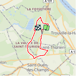
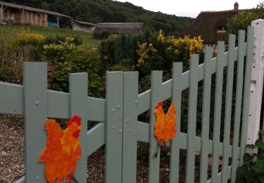
Ruta Senderismo de 10 km a descubrir en Normandía, Eure, Sainte-Opportune-la-Mare. Esta ruta ha sido propuesta por randovivi.
Descripción
Chemin de la Grand-Mare et Chemin de l'allée des Granges.Départ place de l'église de Sainte Opportune la Mare.
Localización
País:
France
Región :
Normandía
Departamento/provincia :
Eure
Municipio :
Sainte-Opportune-la-Mare
Localidad:
Unknown
Salida:(Dec)
Salida:(UTM)
321881 ; 5476751 (31U) N.
Comentarios
Excursiones cerca
![Excursión Senderismo Trouville-la-Haule - Randonnée à Trouville la Haule - Photo](https://media.geolcdn.com/t/375/260/ext.jpg?maxdim=2&url=https%3A%2F%2Fservices.sitytrail.com%2FGeolivesWS%2FDownloadMedia.ashx%3FTrailID%3D107363%26Media%3D12260_1.jpg)
![Senderismo Senderismo](https://static1.geolcdn.com/sitytour/trail-icons/101.png)
Randonnée à Trouville la Haule
Senderismo
Medio
(1)
Trouville-la-Haule,
Normandía,
Eure,
France
![](/images/other/stat-length.png)
14,6 km | 18,6 km-effort
3h 19min
![](https://static1.geolcdn.com/siteimages/upload/files/16400158638029165_repeat_loop_refresh_sync_direction_icon.png)
Sí
![Excursión A pie Sainte-Opportune-la-Mare - Chemin pédestre de l'Allée des Granges - Photo](https://media.geolcdn.com/t/375/260/7933c4e8-7afb-4170-943c-36ad14b0db16.jpeg&format=jpg&maxdim=2)
![A pie A pie](https://static1.geolcdn.com/sitytour/trail-icons/100.png)
Chemin pédestre de l'Allée des Granges
A pie
Fácil
Sainte-Opportune-la-Mare,
Normandía,
Eure,
France
![](/images/other/stat-length.png)
6,4 km | 8,1 km-effort
1h 49min
![](https://static1.geolcdn.com/siteimages/upload/files/16400158638029165_repeat_loop_refresh_sync_direction_icon.png)
Sí
![Excursión Senderismo Bouquelon - Boucle de Bouquelon V2 variante - Photo](https://media.geolcdn.com/t/375/260/ext.jpg?maxdim=2&url=https%3A%2F%2Fstatic1.geolcdn.com%2Fsiteimages%2Fupload%2Ffiles%2F1553511878bg_sport_marche.png)
![Senderismo Senderismo](https://static1.geolcdn.com/sitytour/trail-icons/101.png)
Boucle de Bouquelon V2 variante
Senderismo
Medio
(1)
Bouquelon,
Normandía,
Eure,
France
![](/images/other/stat-length.png)
9,1 km | 11,1 km-effort
2h 31min
![](https://static1.geolcdn.com/siteimages/upload/files/16400158638029165_repeat_loop_refresh_sync_direction_icon.png)
Sí
![Excursión Senderismo Bouquelon - Boucle de Bouquelon V1 - Photo](https://media.geolcdn.com/t/375/260/ext.jpg?maxdim=2&url=https%3A%2F%2Fstatic1.geolcdn.com%2Fsiteimages%2Fupload%2Ffiles%2F1553511878bg_sport_marche.png)
![Senderismo Senderismo](https://static1.geolcdn.com/sitytour/trail-icons/101.png)
Boucle de Bouquelon V1
Senderismo
Difícil
(1)
Bouquelon,
Normandía,
Eure,
France
![](/images/other/stat-length.png)
13,3 km | 16,6 km-effort
3h 46min
![](https://static1.geolcdn.com/siteimages/upload/files/16400158638029165_repeat_loop_refresh_sync_direction_icon.png)
Sí
![Excursión Senderismo Bouquelon - Boucle de Bouquelon V2 - Photo](https://media.geolcdn.com/t/375/260/ext.jpg?maxdim=2&url=https%3A%2F%2Fstatic1.geolcdn.com%2Fsiteimages%2Fupload%2Ffiles%2F1553511878bg_sport_marche.png)
![Senderismo Senderismo](https://static1.geolcdn.com/sitytour/trail-icons/101.png)
Boucle de Bouquelon V2
Senderismo
Medio
(1)
Bouquelon,
Normandía,
Eure,
France
![](/images/other/stat-length.png)
9,4 km | 11,4 km-effort
2h 35min
![](https://static1.geolcdn.com/siteimages/upload/files/16400158638029165_repeat_loop_refresh_sync_direction_icon.png)
Sí
![Excursión Senderismo Trouville-la-Haule - Trouville la Haule . Chemin du Courval - Photo](https://media.geolcdn.com/t/375/260/b18ccded-32f9-499d-b58c-a18fcc72914b.jpg&format=jpg&maxdim=2)
![Senderismo Senderismo](https://static1.geolcdn.com/sitytour/trail-icons/101.png)
Trouville la Haule . Chemin du Courval
Senderismo
Difícil
(1)
Trouville-la-Haule,
Normandía,
Eure,
France
![](/images/other/stat-length.png)
11,8 km | 14,5 km-effort
3h 3min
![](https://static1.geolcdn.com/siteimages/upload/files/16400158638029165_repeat_loop_refresh_sync_direction_icon.png)
Sí
![Excursión Senderismo Le Perrey - chemin des Têtards - Photo](https://media.geolcdn.com/t/375/260/ext.jpg?maxdim=2&url=https%3A%2F%2Fservices.sitytrail.com%2FGeolivesWS%2FDownloadMedia.ashx%3FTrailID%3D487376%26Media%3Dfix__20151030163357.jpg)
![Senderismo Senderismo](https://static1.geolcdn.com/sitytour/trail-icons/101.png)
chemin des Têtards
Senderismo
Medio
Le Perrey,
Normandía,
Eure,
France
![](/images/other/stat-length.png)
7,8 km | 9,2 km-effort
2h 21min
![](https://static1.geolcdn.com/siteimages/upload/files/16400158638029165_repeat_loop_refresh_sync_direction_icon.png)
Sí
![Excursión Senderismo Bouquelon - La Route des chaumières - Photo](https://media.geolcdn.com/t/375/260/a66cd54d-1b43-4979-8d4d-f7a216d7d650.jpg&format=jpg&maxdim=2)
![Senderismo Senderismo](https://static1.geolcdn.com/sitytour/trail-icons/101.png)
La Route des chaumières
Senderismo
Medio
Bouquelon,
Normandía,
Eure,
France
![](/images/other/stat-length.png)
9,3 km | 11,4 km-effort
2h 58min
![](https://static1.geolcdn.com/siteimages/upload/files/16400158638029165_repeat_loop_refresh_sync_direction_icon.png)
Sí
![Excursión Senderismo Bouquelon - Bouquelon - Photo](https://media.geolcdn.com/t/375/260/ext.jpg?maxdim=2&url=https%3A%2F%2Fservices.sitytrail.com%2FGeolivesWS%2FDownloadMedia.ashx%3FTrailID%3D1030710%26Media%3Dfix__20180829152015.jpg)
![Senderismo Senderismo](https://static1.geolcdn.com/sitytour/trail-icons/101.png)
Bouquelon
Senderismo
Muy fácil
Bouquelon,
Normandía,
Eure,
France
![](/images/other/stat-length.png)
13,2 km | 16,4 km-effort
3h 25min
![](https://static1.geolcdn.com/siteimages/upload/files/16400158638029165_repeat_loop_refresh_sync_direction_icon.png)
Sí