![](/images/other/stat-length.png)
![Excursión Senderismo Odenas - Odenas (69) Village - Photo](https://media.geolcdn.com/t/1900/400/ext.pjpeg?maxdim=2&url=https%3A%2F%2Fstatic1.geolcdn.com%2Fsiteimages%2Fupload%2Ffiles%2F1553511878bg_sport_marche.png)
Odenas (69) Village
Thomasdanielle
Usuario
![Longitud](/images/other/stat-length.png)
Longitud
15,2 km
![Altitud máxima](https://static1.geolcdn.com/siteimages/upload/files/1508320355ic_sort_altitude_max_24dp.png)
Altitud máxima
628 m
![Desnivel positivo](https://static1.geolcdn.com/siteimages/upload/files/1508320355ic_sort_den_pos_24dp.png)
Desnivel positivo
557 m
![Km-Effort](/images/other/stat-length.png)
Km-Effort
23 km
![Altitud mínima](https://static1.geolcdn.com/siteimages/upload/files/1508320355ic_sort_altitude_min_24dp.png)
Altitud mínima
263 m
![Desnivel negativo](https://static1.geolcdn.com/siteimages/upload/files/1508320355ic_sort_den_neg_24dp.png)
Desnivel negativo
555 m
![Boucle](https://static1.geolcdn.com/siteimages/upload/files/16400158638029165_repeat_loop_refresh_sync_direction_icon.png)
Boucle
Sí
Fecha de creación :
2017-04-02 00:00:00.0
Última modificación :
2017-04-02 00:00:00.0
![Senderismo](https://static1.geolcdn.com/sitytour/trail-icons/101.png)
4h48
Dificultad : Medio
![Escanee este código QR para abrir la excursión en la aplicación SityTrail](https://capi.geolives.com/qq0zvz2zws4bq2lad0pu/sitytour/trails/725355/qr.png?size=200)
Aplicación GPS de excursión GRATIS
A propósito
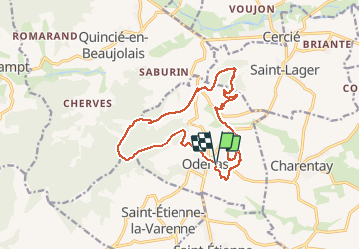
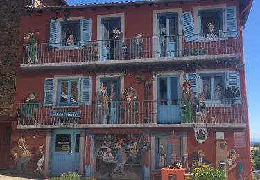
Ruta Senderismo de 15,2 km a descubrir en Auvergne-Rhône-Alpes, Ródano, Odenas. Esta ruta ha sido propuesta por Thomasdanielle.
Descripción
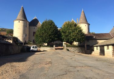
Randonnée Village "Le sous des Ecole" le 02/04/2017.
2 relais très correct et 1 soupe à l'oignon à l'arrivée. Très belle randonnée. Une partie de la randonnée "Chemin privé" à éviter lors d'une randonnée privée.
Localización
País:
France
Región :
Auvergne-Rhône-Alpes
Departamento/provincia :
Ródano
Municipio :
Odenas
Localidad:
Unknown
Salida:(Dec)
Salida:(UTM)
627534 ; 5105225 (31T) N.
Comentarios
Excursiones cerca
![Excursión Paseo ecuestre Quincié-en-Beaujolais - Quincié CxRozier Court - Photo](https://media.geolcdn.com/t/375/260/ext.jpg?maxdim=2&url=https%3A%2F%2Fstatic1.geolcdn.com%2Fsiteimages%2Fupload%2Ffiles%2F1524743154cheval.jpg)
![Paseo ecuestre Paseo ecuestre](https://static1.geolcdn.com/sitytour/trail-icons/301.png)
Quincié CxRozier Court
Paseo ecuestre
Muy difícil
(1)
Quincié-en-Beaujolais,
Auvergne-Rhône-Alpes,
Ródano,
France
![](/images/other/stat-length.png)
28 km | 42 km-effort
5h 33min
![](https://static1.geolcdn.com/siteimages/upload/files/16400158638029165_repeat_loop_refresh_sync_direction_icon.png)
Sí
![Excursión Paseo ecuestre Quincié-en-Beaujolais - Quincié Croix ROZEIR - Photo](https://media.geolcdn.com/t/375/260/ext.jpg?maxdim=2&url=https%3A%2F%2Fstatic1.geolcdn.com%2Fsiteimages%2Fupload%2Ffiles%2F1524743154cheval.jpg)
![Paseo ecuestre Paseo ecuestre](https://static1.geolcdn.com/sitytour/trail-icons/301.png)
Quincié Croix ROZEIR
Paseo ecuestre
Muy difícil
(1)
Quincié-en-Beaujolais,
Auvergne-Rhône-Alpes,
Ródano,
France
![](/images/other/stat-length.png)
31 km | 46 km-effort
6h 3min
![](https://static1.geolcdn.com/siteimages/upload/files/16400158638029165_repeat_loop_refresh_sync_direction_icon.png)
Sí
![Excursión A pie Odenas - SityTrail - 3844657 - etape-3 (1) - Photo](https://media.geolcdn.com/t/375/260/ext.jpg?maxdim=2&url=https%3A%2F%2Fmedia.geolcdn.com%2Ff%2F5616cbb8-73f9-47fc-916f-db065bdc249b.jpg)
![A pie A pie](https://static1.geolcdn.com/sitytour/trail-icons/100.png)
SityTrail - 3844657 - etape-3 (1)
A pie
Difícil
Odenas,
Auvergne-Rhône-Alpes,
Ródano,
France
![](/images/other/stat-length.png)
23 km | 36 km-effort
8h 13min
![](https://static1.geolcdn.com/siteimages/upload/files/16400158638029165_repeat_loop_refresh_sync_direction_icon.png)
No
![Excursión A pie Vaux-en-Beaujolais - SityTrail - 3843016 - etape-2 - Photo](https://media.geolcdn.com/t/375/260/ext.jpg?maxdim=2&url=https%3A%2F%2Fmedia.geolcdn.com%2Ff%2Fe854eec2-8ed0-4512-9e04-68895c0881ec.jpg)
![A pie A pie](https://static1.geolcdn.com/sitytour/trail-icons/100.png)
SityTrail - 3843016 - etape-2
A pie
Muy difícil
Vaux-en-Beaujolais,
Auvergne-Rhône-Alpes,
Ródano,
France
![](/images/other/stat-length.png)
22 km | 35 km-effort
7h 58min
![](https://static1.geolcdn.com/siteimages/upload/files/16400158638029165_repeat_loop_refresh_sync_direction_icon.png)
No
![Excursión Paseo ecuestre Quincié-en-Beaujolais - Quincié Croix - Photo](https://media.geolcdn.com/t/375/260/ext.jpg?maxdim=2&url=https%3A%2F%2Fstatic1.geolcdn.com%2Fsiteimages%2Fupload%2Ffiles%2F1524743154cheval.jpg)
![Paseo ecuestre Paseo ecuestre](https://static1.geolcdn.com/sitytour/trail-icons/301.png)
Quincié Croix
Paseo ecuestre
Difícil
(1)
Quincié-en-Beaujolais,
Auvergne-Rhône-Alpes,
Ródano,
France
![](/images/other/stat-length.png)
26 km | 40 km-effort
5h 14min
![](https://static1.geolcdn.com/siteimages/upload/files/16400158638029165_repeat_loop_refresh_sync_direction_icon.png)
Sí
![Excursión Senderismo Charentay - Charentay (17 km - D. 505 m) - Photo](https://media.geolcdn.com/t/375/260/ext.jpg?maxdim=2&url=https%3A%2F%2Fmedia.geolcdn.com%2Ff%2F4290ed2e-a28d-4273-929c-4cb1315f5c37.jpeg)
![Senderismo Senderismo](https://static1.geolcdn.com/sitytour/trail-icons/101.png)
Charentay (17 km - D. 505 m)
Senderismo
Muy difícil
Charentay,
Auvergne-Rhône-Alpes,
Ródano,
France
![](/images/other/stat-length.png)
16,9 km | 24 km-effort
4h 22min
![](https://static1.geolcdn.com/siteimages/upload/files/16400158638029165_repeat_loop_refresh_sync_direction_icon.png)
Sí
![Excursión Senderismo Vaux-en-Beaujolais - Vaulx en beaujolais - Photo](https://media.geolcdn.com/t/375/260/ext.jpg?maxdim=2&url=https%3A%2F%2Fmedia.geolcdn.com%2Ff%2F5d38e822-f001-465a-8b11-8660c8452a0b.jpg)
![Senderismo Senderismo](https://static1.geolcdn.com/sitytour/trail-icons/101.png)
Vaulx en beaujolais
Senderismo
Fácil
(1)
Vaux-en-Beaujolais,
Auvergne-Rhône-Alpes,
Ródano,
France
![](/images/other/stat-length.png)
14,3 km | 22 km-effort
4h 25min
![](https://static1.geolcdn.com/siteimages/upload/files/16400158638029165_repeat_loop_refresh_sync_direction_icon.png)
Sí
![Excursión Senderismo Quincié-en-Beaujolais - Quincié-En-Beaujolais (10,5 km-D.378) - Photo](https://media.geolcdn.com/t/375/260/ext.jpg?maxdim=2&url=https%3A%2F%2Fservices.sitytrail.com%2FGeolivesWS%2FDownloadMedia.ashx%3FTrailID%3D852331%26Media%3D20171026161848.jpg)
![Senderismo Senderismo](https://static1.geolcdn.com/sitytour/trail-icons/101.png)
Quincié-En-Beaujolais (10,5 km-D.378)
Senderismo
Fácil
Quincié-en-Beaujolais,
Auvergne-Rhône-Alpes,
Ródano,
France
![](/images/other/stat-length.png)
10,4 km | 14,8 km-effort
3h 14min
![](https://static1.geolcdn.com/siteimages/upload/files/16400158638029165_repeat_loop_refresh_sync_direction_icon.png)
Sí
![Excursión Senderismo Le Perréon - le Perréon (69) - Photo](https://media.geolcdn.com/t/375/260/ext.jpg?maxdim=2&url=https%3A%2F%2Fservices.sitytrail.com%2FGeolivesWS%2FDownloadMedia.ashx%3FTrailID%3D661414%26Media%3D20161117165057.jpg)
![Senderismo Senderismo](https://static1.geolcdn.com/sitytour/trail-icons/101.png)
le Perréon (69)
Senderismo
Fácil
Le Perréon,
Auvergne-Rhône-Alpes,
Ródano,
France
![](/images/other/stat-length.png)
10,8 km | 16,5 km-effort
3h 17min
![](https://static1.geolcdn.com/siteimages/upload/files/16400158638029165_repeat_loop_refresh_sync_direction_icon.png)
Sí