![](/images/other/stat-length.png)
![Excursión Senderismo Lombez - lombez circuit du dragon - Photo](https://media.geolcdn.com/t/1900/400/ext.pjpeg?maxdim=2&url=https%3A%2F%2Fstatic1.geolcdn.com%2Fsiteimages%2Fupload%2Ffiles%2F1553511878bg_sport_marche.png)
lombez circuit du dragon
pidjam
Usuario
![Longitud](/images/other/stat-length.png)
Longitud
9 km
![Altitud máxima](https://static1.geolcdn.com/siteimages/upload/files/1508320355ic_sort_altitude_max_24dp.png)
Altitud máxima
263 m
![Desnivel positivo](https://static1.geolcdn.com/siteimages/upload/files/1508320355ic_sort_den_pos_24dp.png)
Desnivel positivo
166 m
![Km-Effort](/images/other/stat-length.png)
Km-Effort
11,2 km
![Altitud mínima](https://static1.geolcdn.com/siteimages/upload/files/1508320355ic_sort_altitude_min_24dp.png)
Altitud mínima
168 m
![Desnivel negativo](https://static1.geolcdn.com/siteimages/upload/files/1508320355ic_sort_den_neg_24dp.png)
Desnivel negativo
165 m
![Boucle](https://static1.geolcdn.com/siteimages/upload/files/16400158638029165_repeat_loop_refresh_sync_direction_icon.png)
Boucle
Sí
Fecha de creación :
2017-03-17 00:00:00.0
Última modificación :
2017-03-17 00:00:00.0
![Senderismo](https://static1.geolcdn.com/sitytour/trail-icons/101.png)
2h27
Dificultad : Fácil
![Escanee este código QR para abrir la excursión en la aplicación SityTrail](https://capi.geolives.com/qq0zvz2zws4bq2lad0pu/sitytour/trails/715071/qr.png?size=200)
Aplicación GPS de excursión GRATIS
A propósito
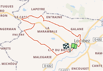
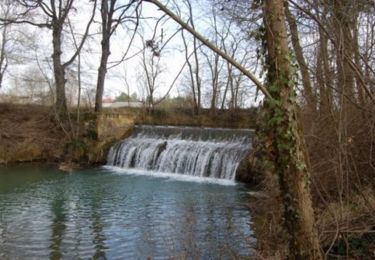
Ruta Senderismo de 9 km a descubrir en Occitania, Gers, Lombez. Esta ruta ha sido propuesta por pidjam.
Descripción
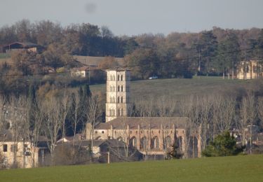
Un parcours agréable dans la campagne gersoise, passage à la chapelle de saint Majan (mythomane local) et à la cathédrale de Lombez.
Localización
País:
France
Región :
Occitania
Departamento/provincia :
Gers
Municipio :
Lombez
Localidad:
Unknown
Salida:(Dec)
Salida:(UTM)
330461 ; 4815210 (31T) N.
Comentarios
Excursiones cerca
![Excursión Senderismo Lombez - Lombez 1 - Photo](https://media.geolcdn.com/t/375/260/ext.jpg?maxdim=2&url=https%3A%2F%2Fservices.sitytrail.com%2FGeolivesWS%2FDownloadMedia.ashx%3FTrailID%3D669985%26Media%3Dee68cfa1-9988-42ef-814e-137d382dd3df.JPG)
![Senderismo Senderismo](https://static1.geolcdn.com/sitytour/trail-icons/101.png)
![Excursión Senderismo Lombez - Balade en bord de Save - Lombez - Photo](https://media.geolcdn.com/t/375/260/ext.jpg?maxdim=2&url=https%3A%2F%2Fservices.sitytrail.com%2FGeolivesWS%2FDownloadMedia.ashx%3FTrailID%3D191619%26Media%3D15260_6.jpg)
![Senderismo Senderismo](https://static1.geolcdn.com/sitytour/trail-icons/101.png)
Balade en bord de Save - Lombez
Senderismo
Fácil
Lombez,
Occitania,
Gers,
France
![](/images/other/stat-length.png)
6,3 km | 6,8 km-effort
1h 34min
![](https://static1.geolcdn.com/siteimages/upload/files/16400158638029165_repeat_loop_refresh_sync_direction_icon.png)
Sí
![Excursión Senderismo Lombez - Autour du Château de Barbet et du Golf (Grand Circuit) - Lombez - Photo](https://media.geolcdn.com/t/375/260/ext.jpg?maxdim=2&url=https%3A%2F%2Fservices.sitytrail.com%2FGeolivesWS%2FDownloadMedia.ashx%3FTrailID%3D191618%26Media%3D15259_3.jpg)
![Senderismo Senderismo](https://static1.geolcdn.com/sitytour/trail-icons/101.png)
Autour du Château de Barbet et du Golf (Grand Circuit) - Lombez
Senderismo
Medio
Lombez,
Occitania,
Gers,
France
![](/images/other/stat-length.png)
9 km | 11,2 km-effort
2h 15min
![](https://static1.geolcdn.com/siteimages/upload/files/16400158638029165_repeat_loop_refresh_sync_direction_icon.png)
Sí
![Excursión Senderismo Lombez - Sur les traces du dragon - Lombez - Photo](https://media.geolcdn.com/t/375/260/ext.jpg?maxdim=2&url=https%3A%2F%2Fservices.sitytrail.com%2FGeolivesWS%2FDownloadMedia.ashx%3FTrailID%3D191617%26Media%3D15258_4.jpg)
![Senderismo Senderismo](https://static1.geolcdn.com/sitytour/trail-icons/101.png)
Sur les traces du dragon - Lombez
Senderismo
Medio
Lombez,
Occitania,
Gers,
France
![](/images/other/stat-length.png)
8,5 km | 10,7 km-effort
2h 10min
![](https://static1.geolcdn.com/siteimages/upload/files/16400158638029165_repeat_loop_refresh_sync_direction_icon.png)
Sí
![Excursión Bici de montaña Samatan - VTT autour de Samatan et Lombez - Photo](https://media.geolcdn.com/t/375/260/ext.jpg?maxdim=2&url=https%3A%2F%2Fservices.sitytrail.com%2FGeolivesWS%2FDownloadMedia.ashx%3FTrailID%3D106535%26Media%3D11094_3.jpg)
![Bici de montaña Bici de montaña](https://static1.geolcdn.com/sitytour/trail-icons/202.png)
VTT autour de Samatan et Lombez
Bici de montaña
Difícil
(1)
Samatan,
Occitania,
Gers,
France
![](/images/other/stat-length.png)
36 km | 44 km-effort
3h 0min
![](https://static1.geolcdn.com/siteimages/upload/files/16400158638029165_repeat_loop_refresh_sync_direction_icon.png)
Sí
![Excursión Senderismo Samatan - Samatan 2020 - Photo](https://media.geolcdn.com/t/375/260/4e60cf98-f1ed-4123-8515-d5dfd8704595.jpg&format=jpg&maxdim=2)
![Senderismo Senderismo](https://static1.geolcdn.com/sitytour/trail-icons/101.png)
![Excursión Senderismo Lombez - De la Ramondère au lieu-dit en Maraillot - Lombez - Photo](https://media.geolcdn.com/t/375/260/ext.jpg?maxdim=2&url=https%3A%2F%2Fservices.sitytrail.com%2FGeolivesWS%2FDownloadMedia.ashx%3FTrailID%3D191621%26Media%3D15262_2.jpg)
![Senderismo Senderismo](https://static1.geolcdn.com/sitytour/trail-icons/101.png)
De la Ramondère au lieu-dit en Maraillot - Lombez
Senderismo
Medio
Lombez,
Occitania,
Gers,
France
![](/images/other/stat-length.png)
8,1 km | 9,5 km-effort
2h 4min
![](https://static1.geolcdn.com/siteimages/upload/files/16400158638029165_repeat_loop_refresh_sync_direction_icon.png)
Sí
![Excursión Senderismo Lombez - Autour du Château de Barbet et du Golf (Petit Circuit) - Lombez - Photo](https://media.geolcdn.com/t/375/260/ext.jpg?maxdim=2&url=https%3A%2F%2Fservices.sitytrail.com%2FGeolivesWS%2FDownloadMedia.ashx%3FTrailID%3D191620%26Media%3D15261_2.jpg)
![Senderismo Senderismo](https://static1.geolcdn.com/sitytour/trail-icons/101.png)
Autour du Château de Barbet et du Golf (Petit Circuit) - Lombez
Senderismo
Fácil
Lombez,
Occitania,
Gers,
France
![](/images/other/stat-length.png)
8,9 km | 11,1 km-effort
1h 49min
![](https://static1.geolcdn.com/siteimages/upload/files/16400158638029165_repeat_loop_refresh_sync_direction_icon.png)
Sí
![Excursión Senderismo Espaon - laprade lombez Barbet sauveterre - Photo](https://media.geolcdn.com/t/375/260/ext.jpg?maxdim=2&url=https%3A%2F%2Fstatic1.geolcdn.com%2Fsiteimages%2Fupload%2Ffiles%2F1553511878bg_sport_marche.png)
![Senderismo Senderismo](https://static1.geolcdn.com/sitytour/trail-icons/101.png)
laprade lombez Barbet sauveterre
Senderismo
Fácil
Espaon,
Occitania,
Gers,
France
![](/images/other/stat-length.png)
15,1 km | 18,2 km-effort
2h 21min
![](https://static1.geolcdn.com/siteimages/upload/files/16400158638029165_repeat_loop_refresh_sync_direction_icon.png)
Sí