![](/images/other/stat-length.png)
![Excursión Senderismo Vers-sous-Sellières - f)Etapa 6 - Photo](https://media.geolcdn.com/t/1900/400/ext.pjpeg?maxdim=2&url=https%3A%2F%2Fservices.sitytrail.com%2FGeolivesWS%2FDownloadMedia.ashx%3FTrailID%3D711079%26Media%3D20170306101034.jpg)
f)Etapa 6
RafaTuareg
Usuario
![Longitud](/images/other/stat-length.png)
Longitud
30 km
![Altitud máxima](https://static1.geolcdn.com/siteimages/upload/files/1508320355ic_sort_altitude_max_24dp.png)
Altitud máxima
230 m
![Desnivel positivo](https://static1.geolcdn.com/siteimages/upload/files/1508320355ic_sort_den_pos_24dp.png)
Desnivel positivo
230 m
![Km-Effort](/images/other/stat-length.png)
Km-Effort
33 km
![Altitud mínima](https://static1.geolcdn.com/siteimages/upload/files/1508320355ic_sort_altitude_min_24dp.png)
Altitud mínima
185 m
![Desnivel negativo](https://static1.geolcdn.com/siteimages/upload/files/1508320355ic_sort_den_neg_24dp.png)
Desnivel negativo
255 m
![Boucle](https://static1.geolcdn.com/siteimages/upload/files/16400158638029165_repeat_loop_refresh_sync_direction_icon.png)
Boucle
No
Fecha de creación :
2017-05-05 00:00:00.0
Última modificación :
2017-05-05 00:00:00.0
![Senderismo](https://static1.geolcdn.com/sitytour/trail-icons/101.png)
4h00
Dificultad : Medio
![Escanee este código QR para abrir la excursión en la aplicación SityTrail](https://capi.geolives.com/qq0zvz2zws4bq2lad0pu/sitytour/trails/711079/qr.png?size=200)
Aplicación GPS de excursión GRATIS
A propósito
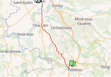
Ruta Senderismo de 30 km a descubrir en Borgoña-Franco Condado, Jura, Vers-sous-Sellières. Esta ruta ha sido propuesta por RafaTuareg.
Descripción
De Vers-sous-Sellières a Molay
Localización
País:
France
Región :
Borgoña-Franco Condado
Departamento/provincia :
Jura
Municipio :
Vers-sous-Sellières
Localidad:
Unknown
Salida:(Dec)
Salida:(UTM)
693213 ; 5188957 (31T) N.
Comentarios
Excursiones cerca
![Senderismo Senderismo](https://static1.geolcdn.com/sitytour/trail-icons/101.png)
Sellière Toulouse le Château 5 août 2021 (IBP 62) CAF
Senderismo
Medio
Sellières,
Borgoña-Franco Condado,
Jura,
France
![](/images/other/stat-length.png)
23 km | 29 km-effort
6h 10min
![](https://static1.geolcdn.com/siteimages/upload/files/16400158638029165_repeat_loop_refresh_sync_direction_icon.png)
Sí
![Excursión Senderismo Mantry - sentiers de découverte Brery Mantry - Photo](https://media.geolcdn.com/t/375/260/47bf2d8e-7391-45ab-b377-066c15e6c67a.jpg&format=jpg&maxdim=2)
![Senderismo Senderismo](https://static1.geolcdn.com/sitytour/trail-icons/101.png)
sentiers de découverte Brery Mantry
Senderismo
Muy fácil
Mantry,
Borgoña-Franco Condado,
Jura,
France
![](/images/other/stat-length.png)
6,3 km | 8 km-effort
1h 47min
![](https://static1.geolcdn.com/siteimages/upload/files/16400158638029165_repeat_loop_refresh_sync_direction_icon.png)
No
![Excursión Bici de montaña Chaumergy - VTT Maison des étangs Ouest - Chaumergy - Photo](https://media.geolcdn.com/t/375/260/ext.jpg?maxdim=2&url=https%3A%2F%2Fservices.sitytrail.com%2FGeolivesWS%2FDownloadMedia.ashx%3FTrailID%3D111439%26Media%3D7270_2.jpg)
![Bici de montaña Bici de montaña](https://static1.geolcdn.com/sitytour/trail-icons/202.png)
VTT Maison des étangs Ouest - Chaumergy
Bici de montaña
Fácil
Chaumergy,
Borgoña-Franco Condado,
Jura,
France
![](/images/other/stat-length.png)
21 km | 23 km-effort
2h 0min
![](https://static1.geolcdn.com/siteimages/upload/files/16400158638029165_repeat_loop_refresh_sync_direction_icon.png)
Sí
![Excursión Senderismo Vincent-Froideville - vence - Photo](https://media.geolcdn.com/t/375/260/ext.jpg?maxdim=2&url=https%3A%2F%2Fstatic1.geolcdn.com%2Fsiteimages%2Fupload%2Ffiles%2F1553511878bg_sport_marche.png)
![Senderismo Senderismo](https://static1.geolcdn.com/sitytour/trail-icons/101.png)
vence
Senderismo
Difícil
Vincent-Froideville,
Borgoña-Franco Condado,
Jura,
France
![](/images/other/stat-length.png)
13,1 km | 15,4 km-effort
4h 48min
![](https://static1.geolcdn.com/siteimages/upload/files/16400158638029165_repeat_loop_refresh_sync_direction_icon.png)
Sí
![Excursión Senderismo Sellières - sellières 1 - Photo](https://media.geolcdn.com/t/375/260/ext.jpg?maxdim=2&url=https%3A%2F%2Fstatic1.geolcdn.com%2Fsiteimages%2Fupload%2Ffiles%2F1553511878bg_sport_marche.png)
![Senderismo Senderismo](https://static1.geolcdn.com/sitytour/trail-icons/101.png)
sellières 1
Senderismo
Medio
Sellières,
Borgoña-Franco Condado,
Jura,
France
![](/images/other/stat-length.png)
4,6 km | 5,5 km-effort
1h 8min
![](https://static1.geolcdn.com/siteimages/upload/files/16400158638029165_repeat_loop_refresh_sync_direction_icon.png)
No
![Excursión Senderismo Sellières - Sellieres Toulouse le Château 7 juillet 2021 (IBP 62) reco CAF - Photo](https://media.geolcdn.com/t/375/260/ext.jpg?maxdim=2&url=https%3A%2F%2Fstatic1.geolcdn.com%2Fsiteimages%2Fupload%2Ffiles%2F1553511878bg_sport_marche.png)
![Senderismo Senderismo](https://static1.geolcdn.com/sitytour/trail-icons/101.png)
Sellieres Toulouse le Château 7 juillet 2021 (IBP 62) reco CAF
Senderismo
Medio
Sellières,
Borgoña-Franco Condado,
Jura,
France
![](/images/other/stat-length.png)
23 km | 28 km-effort
6h 20min
![](https://static1.geolcdn.com/siteimages/upload/files/16400158638029165_repeat_loop_refresh_sync_direction_icon.png)
Sí
![Excursión Senderismo Mantry - Mantry - Photo](https://media.geolcdn.com/t/375/260/ext.jpg?maxdim=2&url=https%3A%2F%2Fstatic1.geolcdn.com%2Fsiteimages%2Fupload%2Ffiles%2F1553511878bg_sport_marche.png)
![Senderismo Senderismo](https://static1.geolcdn.com/sitytour/trail-icons/101.png)
Mantry
Senderismo
Fácil
Mantry,
Borgoña-Franco Condado,
Jura,
France
![](/images/other/stat-length.png)
10,6 km | 14,3 km-effort
3h 3min
![](https://static1.geolcdn.com/siteimages/upload/files/16400158638029165_repeat_loop_refresh_sync_direction_icon.png)
Sí
![Excursión Paseo ecuestre Toulouse-le-Château - rando mai 2025 - Photo](https://media.geolcdn.com/t/375/260/ext.jpg?maxdim=2&url=https%3A%2F%2Fstatic1.geolcdn.com%2Fsiteimages%2Fupload%2Ffiles%2F1524743154cheval.jpg)
![Paseo ecuestre Paseo ecuestre](https://static1.geolcdn.com/sitytour/trail-icons/301.png)
rando mai 2025
Paseo ecuestre
Muy difícil
Toulouse-le-Château,
Borgoña-Franco Condado,
Jura,
France
![](/images/other/stat-length.png)
151 km | 201 km-effort
26h 25min
![](https://static1.geolcdn.com/siteimages/upload/files/16400158638029165_repeat_loop_refresh_sync_direction_icon.png)
Sí
![Excursión Senderismo Sellières - Sellieres Mantry 20 km - Photo](https://media.geolcdn.com/t/375/260/ext.jpg?maxdim=2&url=https%3A%2F%2Fstatic1.geolcdn.com%2Fsiteimages%2Fupload%2Ffiles%2F1553511878bg_sport_marche.png)
![Senderismo Senderismo](https://static1.geolcdn.com/sitytour/trail-icons/101.png)
Sellieres Mantry 20 km
Senderismo
Muy difícil
Sellières,
Borgoña-Franco Condado,
Jura,
France
![](/images/other/stat-length.png)
21 km | 27 km-effort
6h 43min
![](https://static1.geolcdn.com/siteimages/upload/files/16400158638029165_repeat_loop_refresh_sync_direction_icon.png)
Sí