![](/images/other/stat-length.png)
![Excursión Senderismo Életot - 076-03-journée FÉCAMP 20km 704-435 - Photo](https://media.geolcdn.com/t/1900/400/b737ec8e-3b78-4375-bb7d-76b95ec6a2b6.jpg&format=pjpeg&maxdim=2)
076-03-journée FÉCAMP 20km 704-435
rvs147
Usuario
![Longitud](/images/other/stat-length.png)
Longitud
19,9 km
![Altitud máxima](https://static1.geolcdn.com/siteimages/upload/files/1508320355ic_sort_altitude_max_24dp.png)
Altitud máxima
123 m
![Desnivel positivo](https://static1.geolcdn.com/siteimages/upload/files/1508320355ic_sort_den_pos_24dp.png)
Desnivel positivo
282 m
![Km-Effort](/images/other/stat-length.png)
Km-Effort
24 km
![Altitud mínima](https://static1.geolcdn.com/siteimages/upload/files/1508320355ic_sort_altitude_min_24dp.png)
Altitud mínima
2 m
![Desnivel negativo](https://static1.geolcdn.com/siteimages/upload/files/1508320355ic_sort_den_neg_24dp.png)
Desnivel negativo
376 m
![Boucle](https://static1.geolcdn.com/siteimages/upload/files/16400158638029165_repeat_loop_refresh_sync_direction_icon.png)
Boucle
No
Fecha de creación :
2017-07-10 00:00:00.0
Última modificación :
2022-09-20 13:22:43.166
![Senderismo](https://static1.geolcdn.com/sitytour/trail-icons/101.png)
5h13
Dificultad : Medio
![Escanee este código QR para abrir la excursión en la aplicación SityTrail](https://capi.geolives.com/qq0zvz2zws4bq2lad0pu/sitytour/trails/704435/qr.png?size=200)
Aplicación GPS de excursión GRATIS
A propósito
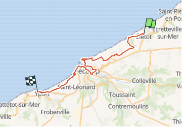
Ruta Senderismo de 19,9 km a descubrir en Normandía, Sena-Marítimo, Életot. Esta ruta ha sido propuesta por rvs147.
Descripción
Départ Église d'Életot
glise d'Életot
Arrivé Parking Casino YPORT
rue des Falaises
environ 20km
Localización
País:
France
Región :
Normandía
Departamento/provincia :
Sena-Marítimo
Municipio :
Életot
Localidad:
Unknown
Salida:(Dec)
Salida:(UTM)
316614 ; 5518316 (31U) N.
Comentarios
Excursiones cerca
![Excursión Senderismo Fécamp - Nid Verdier - Val aux lièvres - Photo](https://media.geolcdn.com/t/375/260/ext.jpg?maxdim=2&url=https%3A%2F%2Fstatic1.geolcdn.com%2Fsiteimages%2Fupload%2Ffiles%2F1553511878bg_sport_marche.png)
![Senderismo Senderismo](https://static1.geolcdn.com/sitytour/trail-icons/101.png)
Nid Verdier - Val aux lièvres
Senderismo
Medio
(1)
Fécamp,
Normandía,
Sena-Marítimo,
France
![](/images/other/stat-length.png)
6,3 km | 7,8 km-effort
1h 42min
![](https://static1.geolcdn.com/siteimages/upload/files/16400158638029165_repeat_loop_refresh_sync_direction_icon.png)
Sí
![Excursión Bici de carretera Saint-Pierre-en-Port - Les grandes dalles (pays de Caux) - Photo](https://media.geolcdn.com/t/375/260/54226a6d-f552-4aa0-9b9a-50d83abaf092.jpg&format=jpg&maxdim=2)
![Bici de carretera Bici de carretera](https://static1.geolcdn.com/sitytour/trail-icons/201.png)
Les grandes dalles (pays de Caux)
Bici de carretera
Muy fácil
Saint-Pierre-en-Port,
Normandía,
Sena-Marítimo,
France
![](/images/other/stat-length.png)
71 km | 83 km-effort
4h 14min
![](https://static1.geolcdn.com/siteimages/upload/files/16400158638029165_repeat_loop_refresh_sync_direction_icon.png)
No
![Excursión Bici de carretera Saint-Pierre-en-Port - Les grandes dalles - Photo](https://media.geolcdn.com/t/375/260/50c79e5f-aadc-4e00-b24a-21049f9c7227.jpg&format=jpg&maxdim=2)
![Bici de carretera Bici de carretera](https://static1.geolcdn.com/sitytour/trail-icons/201.png)
Les grandes dalles
Bici de carretera
Fácil
Saint-Pierre-en-Port,
Normandía,
Sena-Marítimo,
France
![](/images/other/stat-length.png)
71 km | 80 km-effort
4h 26min
![](https://static1.geolcdn.com/siteimages/upload/files/16400158638029165_repeat_loop_refresh_sync_direction_icon.png)
Sí
![Excursión Senderismo Saint-Pierre-en-Port - Saint Pierre - Photo](https://media.geolcdn.com/t/375/260/ext.jpg?maxdim=2&url=https%3A%2F%2Fstatic1.geolcdn.com%2Fsiteimages%2Fupload%2Ffiles%2F1553511878bg_sport_marche.png)
![Senderismo Senderismo](https://static1.geolcdn.com/sitytour/trail-icons/101.png)
Saint Pierre
Senderismo
Fácil
Saint-Pierre-en-Port,
Normandía,
Sena-Marítimo,
France
![](/images/other/stat-length.png)
11,9 km | 14,4 km-effort
4h 3min
![](https://static1.geolcdn.com/siteimages/upload/files/16400158638029165_repeat_loop_refresh_sync_direction_icon.png)
Sí
![Excursión A pie Senneville-sur-Fécamp - GR 21-Etape 4 - Photo](https://media.geolcdn.com/t/375/260/ext.jpg?maxdim=2&url=https%3A%2F%2Fstatic1.geolcdn.com%2Fsiteimages%2Fupload%2Ffiles%2F1545311037marcheuse_200dpi.jpg)
![A pie A pie](https://static1.geolcdn.com/sitytour/trail-icons/100.png)
GR 21-Etape 4
A pie
Difícil
Senneville-sur-Fécamp,
Normandía,
Sena-Marítimo,
France
![](/images/other/stat-length.png)
25 km | 31 km-effort
8h 0min
![](https://static1.geolcdn.com/siteimages/upload/files/16400158638029165_repeat_loop_refresh_sync_direction_icon.png)
No
![Excursión Bici de montaña Saint-Pierre-en-Port - VTT-19-05-2019 - Photo](https://media.geolcdn.com/t/375/260/ext.jpg?maxdim=2&url=https%3A%2F%2Fstatic1.geolcdn.com%2Fsiteimages%2Fupload%2Ffiles%2F1524743154velo.jpg)
![Bici de montaña Bici de montaña](https://static1.geolcdn.com/sitytour/trail-icons/202.png)
VTT-19-05-2019
Bici de montaña
Muy fácil
Saint-Pierre-en-Port,
Normandía,
Sena-Marítimo,
France
![](/images/other/stat-length.png)
64 km | 74 km-effort
3h 40min
![](https://static1.geolcdn.com/siteimages/upload/files/16400158638029165_repeat_loop_refresh_sync_direction_icon.png)
No
![Excursión Senderismo Fécamp - Fecamp - La chapelle - Photo](https://media.geolcdn.com/t/375/260/ext.jpg?maxdim=2&url=https%3A%2F%2Fstatic1.geolcdn.com%2Fsiteimages%2Fupload%2Ffiles%2F1553511878bg_sport_marche.png)
![Senderismo Senderismo](https://static1.geolcdn.com/sitytour/trail-icons/101.png)
Fecamp - La chapelle
Senderismo
Medio
Fécamp,
Normandía,
Sena-Marítimo,
France
![](/images/other/stat-length.png)
8,1 km | 10,4 km-effort
2h 18min
![](https://static1.geolcdn.com/siteimages/upload/files/16400158638029165_repeat_loop_refresh_sync_direction_icon.png)
Sí
![Excursión Senderismo Fécamp - Le Grand Ganzeville - Photo](https://media.geolcdn.com/t/375/260/ext.jpg?maxdim=2&url=https%3A%2F%2Fstatic1.geolcdn.com%2Fsiteimages%2Fupload%2Ffiles%2F1553511878bg_sport_marche.png)
![Senderismo Senderismo](https://static1.geolcdn.com/sitytour/trail-icons/101.png)
Le Grand Ganzeville
Senderismo
Difícil
Fécamp,
Normandía,
Sena-Marítimo,
France
![](/images/other/stat-length.png)
8,3 km | 10 km-effort
2h 11min
![](https://static1.geolcdn.com/siteimages/upload/files/16400158638029165_repeat_loop_refresh_sync_direction_icon.png)
Sí
![Excursión Senderismo Fécamp - Bosclong - La Roquette - Photo](https://media.geolcdn.com/t/375/260/ext.jpg?maxdim=2&url=https%3A%2F%2Fstatic1.geolcdn.com%2Fsiteimages%2Fupload%2Ffiles%2F1553511878bg_sport_marche.png)
![Senderismo Senderismo](https://static1.geolcdn.com/sitytour/trail-icons/101.png)
Bosclong - La Roquette
Senderismo
Medio
Fécamp,
Normandía,
Sena-Marítimo,
France
![](/images/other/stat-length.png)
9,2 km | 10,9 km-effort
2h 20min
![](https://static1.geolcdn.com/siteimages/upload/files/16400158638029165_repeat_loop_refresh_sync_direction_icon.png)
Sí