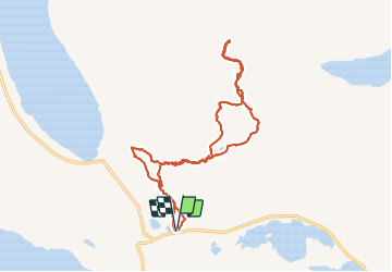
![](/images/other/stat-length.png)
![Excursión Senderismo Unknown - Senja - Keipen (938m) - Photo](https://media.geolcdn.com/t/1900/400/ext.pjpeg?maxdim=2&url=https%3A%2F%2Fstatic1.geolcdn.com%2Fsiteimages%2Fupload%2Ffiles%2F1553511878bg_sport_marche.png)
Senja - Keipen (938m)
michel.heusschen@skynet.be
Usuario
![Longitud](/images/other/stat-length.png)
![Altitud máxima](https://static1.geolcdn.com/siteimages/upload/files/1508320355ic_sort_altitude_max_24dp.png)
![Desnivel positivo](https://static1.geolcdn.com/siteimages/upload/files/1508320355ic_sort_den_pos_24dp.png)
![Km-Effort](/images/other/stat-length.png)
![Altitud mínima](https://static1.geolcdn.com/siteimages/upload/files/1508320355ic_sort_altitude_min_24dp.png)
![Desnivel negativo](https://static1.geolcdn.com/siteimages/upload/files/1508320355ic_sort_den_neg_24dp.png)
![Boucle](https://static1.geolcdn.com/siteimages/upload/files/16400158638029165_repeat_loop_refresh_sync_direction_icon.png)
![Senderismo](https://static1.geolcdn.com/sitytour/trail-icons/101.png)
4h00
Dificultad : Medio
![Escanee este código QR para abrir la excursión en la aplicación SityTrail](https://capi.geolives.com/qq0zvz2zws4bq2lad0pu/sitytour/trails/70409/qr.png?size=200)
Aplicación GPS de excursión GRATIS
A propósito
Ruta Senderismo de 10,9 km a descubrir en Troms og Finnmark. Esta ruta ha sido propuesta por michel.heusschen@skynet.be.
Descripción
Keipen (938m)
GPS Tracks 19.07.2011
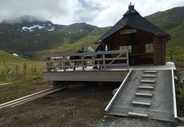
Start Mefjordeidet near the Ørnfjord Tunnel. Suitable for most people, including children who are keen hikers, but not people with a fear of heights. In the evening sun/Midnight Sun, there is a spectacular view of the mountain formation Nordlandet and the open sea. There is a car park near the start of the hike.
Localización
Comentarios