![](/images/other/stat-length.png)
![Excursión Senderismo Vesly - Vesly Authevernes Guerny - Photo](https://media.geolcdn.com/t/1900/400/ext.pjpeg?maxdim=2&url=https%3A%2F%2Fservices.sitytrail.com%2FGeolivesWS%2FDownloadMedia.ashx%3FTrailID%3D699815%26Media%3Dfix__20170216105151.jpg)
Vesly Authevernes Guerny
Marie-Claire-mcp
Usuario
![Longitud](/images/other/stat-length.png)
Longitud
10,9 km
![Altitud máxima](https://static1.geolcdn.com/siteimages/upload/files/1508320355ic_sort_altitude_max_24dp.png)
Altitud máxima
147 m
![Desnivel positivo](https://static1.geolcdn.com/siteimages/upload/files/1508320355ic_sort_den_pos_24dp.png)
Desnivel positivo
183 m
![Km-Effort](/images/other/stat-length.png)
Km-Effort
13,3 km
![Altitud mínima](https://static1.geolcdn.com/siteimages/upload/files/1508320355ic_sort_altitude_min_24dp.png)
Altitud mínima
48 m
![Desnivel negativo](https://static1.geolcdn.com/siteimages/upload/files/1508320355ic_sort_den_neg_24dp.png)
Desnivel negativo
188 m
![Boucle](https://static1.geolcdn.com/siteimages/upload/files/16400158638029165_repeat_loop_refresh_sync_direction_icon.png)
Boucle
No
Fecha de creación :
2017-02-17 00:00:00.0
Última modificación :
2017-02-17 00:00:00.0
![Senderismo](https://static1.geolcdn.com/sitytour/trail-icons/101.png)
2h53
Dificultad : Desconocido
![Escanee este código QR para abrir la excursión en la aplicación SityTrail](https://capi.geolives.com/qq0zvz2zws4bq2lad0pu/sitytour/trails/699815/qr.png?size=200)
Aplicación GPS de excursión GRATIS
A propósito
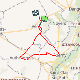
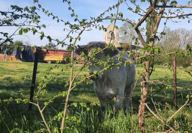
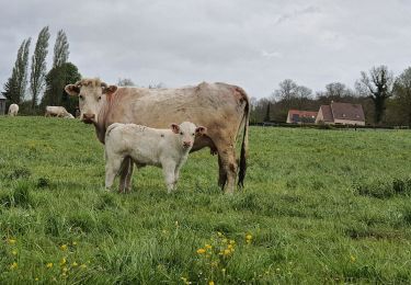
Ruta Senderismo de 10,9 km a descubrir en Normandía, Eure, Vesly. Esta ruta ha sido propuesta por Marie-Claire-mcp.
Descripción
Départ de l'entrée de Vesly, puis route de Guerny et à droite chemin sur Authevernes, Traversée d'Authevernes par le fort, puis traversée de la nationale 14, ensuite tout droit jusqu'à Guerny puis à gauche la belle côte et direction Vesly.
Localización
País:
France
Región :
Normandía
Departamento/provincia :
Eure
Municipio :
Vesly
Localidad:
Unknown
Salida:(Dec)
Salida:(UTM)
402259 ; 5455194 (31U) N.
Comentarios
Excursiones cerca
![Excursión Senderismo Château-sur-Epte - Château sur Epte - Berthenonville - Photo](https://media.geolcdn.com/t/375/260/ext.jpg?maxdim=2&url=https%3A%2F%2Fservices.sitytrail.com%2FGeolivesWS%2FDownloadMedia.ashx%3FTrailID%3D891370%26Media%3D28f306c4-ccd7-4e45-8d5f-378c794acdd1.jpg)
![Senderismo Senderismo](https://static1.geolcdn.com/sitytour/trail-icons/101.png)
Château sur Epte - Berthenonville
Senderismo
Fácil
(1)
Château-sur-Epte,
Normandía,
Eure,
France
![](/images/other/stat-length.png)
7,8 km | 9,5 km-effort
2h 7min
![](https://static1.geolcdn.com/siteimages/upload/files/16400158638029165_repeat_loop_refresh_sync_direction_icon.png)
Sí
![Excursión Senderismo Château-sur-Epte - Château sur Epte - Rollon Nord - Photo](https://media.geolcdn.com/t/375/260/ext.jpg?maxdim=2&url=https%3A%2F%2Fservices.sitytrail.com%2FGeolivesWS%2FDownloadMedia.ashx%3FTrailID%3D158414%26Media%3Df92478f2-a815-4319-b098-de4877cf6291.jpg)
![Senderismo Senderismo](https://static1.geolcdn.com/sitytour/trail-icons/101.png)
Château sur Epte - Rollon Nord
Senderismo
Fácil
(1)
Château-sur-Epte,
Normandía,
Eure,
France
![](/images/other/stat-length.png)
8,4 km | 10,2 km-effort
2h 2min
![](https://static1.geolcdn.com/siteimages/upload/files/16400158638029165_repeat_loop_refresh_sync_direction_icon.png)
Sí
![Excursión Senderismo Noyers - Noyers - Vesly et ND du chêne - Photo](https://media.geolcdn.com/t/375/260/ext.jpg?maxdim=2&url=https%3A%2F%2Fstatic1.geolcdn.com%2Fsiteimages%2Fupload%2Ffiles%2F1553511878bg_sport_marche.png)
![Senderismo Senderismo](https://static1.geolcdn.com/sitytour/trail-icons/101.png)
Noyers - Vesly et ND du chêne
Senderismo
Medio
(1)
Noyers,
Normandía,
Eure,
France
![](/images/other/stat-length.png)
13,6 km | 16,5 km-effort
2h 30min
![](https://static1.geolcdn.com/siteimages/upload/files/16400158638029165_repeat_loop_refresh_sync_direction_icon.png)
Sí
![Excursión Marcha nórdica Authevernes - MN 57 Authevernes - Photo](https://media.geolcdn.com/t/375/260/ext.jpg?maxdim=2&url=https%3A%2F%2Fstatic1.geolcdn.com%2Fsiteimages%2Fupload%2Ffiles%2F1545311037marcheuse_200dpi.jpg)
![Marcha nórdica Marcha nórdica](https://static1.geolcdn.com/sitytour/trail-icons/102.png)
MN 57 Authevernes
Marcha nórdica
Fácil
(3)
Authevernes,
Normandía,
Eure,
France
![](/images/other/stat-length.png)
8,5 km | 10,1 km-effort
1h 30min
![](https://static1.geolcdn.com/siteimages/upload/files/16400158638029165_repeat_loop_refresh_sync_direction_icon.png)
Sí
![Excursión Senderismo Vesly - Vesly - Authevernes - Photo](https://media.geolcdn.com/t/375/260/ext.jpg?maxdim=2&url=https%3A%2F%2Fstatic1.geolcdn.com%2Fsiteimages%2Fupload%2Ffiles%2F1553511878bg_sport_marche.png)
![Senderismo Senderismo](https://static1.geolcdn.com/sitytour/trail-icons/101.png)
Vesly - Authevernes
Senderismo
Fácil
(1)
Vesly,
Normandía,
Eure,
France
![](/images/other/stat-length.png)
8,9 km | 10,5 km-effort
2h 11min
![](https://static1.geolcdn.com/siteimages/upload/files/16400158638029165_repeat_loop_refresh_sync_direction_icon.png)
Sí
![Excursión Senderismo Guerny - Gisancourt - Notre Dame du Chêne - Photo](https://media.geolcdn.com/t/375/260/ext.jpg?maxdim=2&url=https%3A%2F%2Fstatic1.geolcdn.com%2Fsiteimages%2Fupload%2Ffiles%2F1553511878bg_sport_marche.png)
![Senderismo Senderismo](https://static1.geolcdn.com/sitytour/trail-icons/101.png)
Gisancourt - Notre Dame du Chêne
Senderismo
Fácil
(2)
Guerny,
Normandía,
Eure,
France
![](/images/other/stat-length.png)
11,6 km | 13,9 km-effort
3h 2min
![](https://static1.geolcdn.com/siteimages/upload/files/16400158638029165_repeat_loop_refresh_sync_direction_icon.png)
Sí
![Excursión Senderismo Vesly - VESLY Guerny+ND du Chêne - Photo](https://media.geolcdn.com/t/375/260/ext.jpg?maxdim=2&url=https%3A%2F%2Fstatic1.geolcdn.com%2Fsiteimages%2Fupload%2Ffiles%2F1553511878bg_sport_marche.png)
![Senderismo Senderismo](https://static1.geolcdn.com/sitytour/trail-icons/101.png)
VESLY Guerny+ND du Chêne
Senderismo
Fácil
(1)
Vesly,
Normandía,
Eure,
France
![](/images/other/stat-length.png)
9,9 km | 12,4 km-effort
2h 41min
![](https://static1.geolcdn.com/siteimages/upload/files/16400158638029165_repeat_loop_refresh_sync_direction_icon.png)
Sí
![Excursión Senderismo Vesly - Vesly côte de Guerny Gisancourt et le chêne, ferme de Nainville - Photo](https://media.geolcdn.com/t/375/260/672dd815-f964-4745-bb5d-c86df75a6f84.jpg&format=jpg&maxdim=2)
![Senderismo Senderismo](https://static1.geolcdn.com/sitytour/trail-icons/101.png)
Vesly côte de Guerny Gisancourt et le chêne, ferme de Nainville
Senderismo
Difícil
Vesly,
Normandía,
Eure,
France
![](/images/other/stat-length.png)
10,1 km | 12,5 km-effort
2h 25min
![](https://static1.geolcdn.com/siteimages/upload/files/16400158638029165_repeat_loop_refresh_sync_direction_icon.png)
Sí
![Excursión Senderismo Vesly - Vesly - Ferme de Nainville - Le chêne - Gisancourt - voie verte - Noyers - Photo](https://media.geolcdn.com/t/375/260/afe74b32-8e0d-470c-8800-b3e5001c11e2.jpg&format=jpg&maxdim=2)
![Senderismo Senderismo](https://static1.geolcdn.com/sitytour/trail-icons/101.png)
Vesly - Ferme de Nainville - Le chêne - Gisancourt - voie verte - Noyers
Senderismo
Difícil
Vesly,
Normandía,
Eure,
France
![](/images/other/stat-length.png)
12,6 km | 15,3 km-effort
3h 14min
![](https://static1.geolcdn.com/siteimages/upload/files/16400158638029165_repeat_loop_refresh_sync_direction_icon.png)
Sí