![](/images/other/stat-length.png)
![Excursión Senderismo Rives-en-Seine - St-Wandrille-Rançon 2016-05-18 PT - 7KM - Photo](https://media.geolcdn.com/t/1900/400/ext.pjpeg?maxdim=2&url=https%3A%2F%2Fstatic1.geolcdn.com%2Fsiteimages%2Fupload%2Ffiles%2F1553511878bg_sport_marche.png)
St-Wandrille-Rançon 2016-05-18 PT - 7KM
philippe76
Usuario
![Longitud](/images/other/stat-length.png)
![Altitud máxima](https://static1.geolcdn.com/siteimages/upload/files/1508320355ic_sort_altitude_max_24dp.png)
![Desnivel positivo](https://static1.geolcdn.com/siteimages/upload/files/1508320355ic_sort_den_pos_24dp.png)
![Km-Effort](/images/other/stat-length.png)
![Altitud mínima](https://static1.geolcdn.com/siteimages/upload/files/1508320355ic_sort_altitude_min_24dp.png)
![Desnivel negativo](https://static1.geolcdn.com/siteimages/upload/files/1508320355ic_sort_den_neg_24dp.png)
![Boucle](https://static1.geolcdn.com/siteimages/upload/files/16400158638029165_repeat_loop_refresh_sync_direction_icon.png)
![Senderismo](https://static1.geolcdn.com/sitytour/trail-icons/101.png)
1h58
Dificultad : Medio
![Escanee este código QR para abrir la excursión en la aplicación SityTrail](https://capi.geolives.com/qq0zvz2zws4bq2lad0pu/sitytour/trails/696685/qr.png?size=200)
Aplicación GPS de excursión GRATIS
A propósito
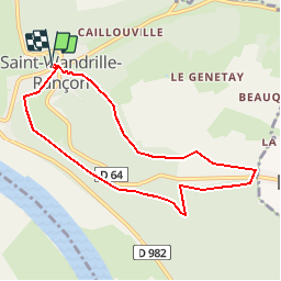
Ruta Senderismo de 7,2 km a descubrir en Normandía, Sena-Marítimo, Rives-en-Seine. Esta ruta ha sido propuesta por philippe76.
Descripción
Départ au niveau du PKG de St-Wandrille-Rançon.Prendre AD Rue de la Coutume, TD, AG Chemin du Relais. AG au Pylone, suivre le GR2, TD jusqu'à la rte ftière de Caudebecquetet la prendre AD, Premier chemin AG, TD, AD Al Rte Ftière de Caudebecquet, prendre AD et AG, puis AG et TD. AD avant la D64 et TD puia AG. Traverser la D64, AD et tout de suite AG, puis chemin AG passer sous la ligne HT.AG rte des Communaux, puis AD et Tjours TD Chemin des barreaux bleux. Terminer par la sente de la messe puis arrivée PKG.
Localización
Comentarios
Excursiones cerca
![Excursión Senderismo Rives-en-Seine - saint marguerite sur duclair - Photo](https://media.geolcdn.com/t/375/260/e79a805c-23a8-4b82-8445-cd3cb02d88fd.jpg&format=jpg&maxdim=2)
![Senderismo Senderismo](https://static1.geolcdn.com/sitytour/trail-icons/101.png)
Senderismo
![](/images/other/stat-length.png)
![](https://static1.geolcdn.com/siteimages/upload/files/16400158638029165_repeat_loop_refresh_sync_direction_icon.png)
![Excursión Senderismo Notre-Dame-de-Bliquetuit - Notre Dame de Bliquetuit vers l'Armada 18km -sans photos - Photo](https://media.geolcdn.com/t/375/260/70cbc6b4-289e-4f31-9eb1-cafb40f9cb50.jpg&format=jpg&maxdim=2)
![Senderismo Senderismo](https://static1.geolcdn.com/sitytour/trail-icons/101.png)
Senderismo
![](/images/other/stat-length.png)
![](https://static1.geolcdn.com/siteimages/upload/files/16400158638029165_repeat_loop_refresh_sync_direction_icon.png)
![Excursión Senderismo Notre-Dame-de-Bliquetuit - Notre Dame de Bliquetuit vers l'Armada 18km - Photo](https://media.geolcdn.com/t/375/260/70cbc6b4-289e-4f31-9eb1-cafb40f9cb50.jpg&format=jpg&maxdim=2)
![Senderismo Senderismo](https://static1.geolcdn.com/sitytour/trail-icons/101.png)
Senderismo
![](/images/other/stat-length.png)
![](https://static1.geolcdn.com/siteimages/upload/files/16400158638029165_repeat_loop_refresh_sync_direction_icon.png)
![Excursión Senderismo Rives-en-Seine - saint wandrille 76 - Photo](https://media.geolcdn.com/t/375/260/93ae6a7b-c754-44fd-a552-6b50bdaf0db6.jpg&format=jpg&maxdim=2)
![Senderismo Senderismo](https://static1.geolcdn.com/sitytour/trail-icons/101.png)
Senderismo
![](/images/other/stat-length.png)
![](https://static1.geolcdn.com/siteimages/upload/files/16400158638029165_repeat_loop_refresh_sync_direction_icon.png)
![Senderismo Senderismo](https://static1.geolcdn.com/sitytour/trail-icons/101.png)
Senderismo
![](/images/other/stat-length.png)
![](https://static1.geolcdn.com/siteimages/upload/files/16400158638029165_repeat_loop_refresh_sync_direction_icon.png)
![Excursión Senderismo Notre-Dame-de-Bliquetuit - Notre Dame de Bliquetuit - Photo](https://media.geolcdn.com/t/375/260/ext.jpg?maxdim=2&url=https%3A%2F%2Fservices.sitytrail.com%2FGeolivesWS%2FDownloadMedia.ashx%3FTrailID%3D1136395%26Media%3Dfix__20190418180542.jpg)
![Senderismo Senderismo](https://static1.geolcdn.com/sitytour/trail-icons/101.png)
Senderismo
![](/images/other/stat-length.png)
![](https://static1.geolcdn.com/siteimages/upload/files/16400158638029165_repeat_loop_refresh_sync_direction_icon.png)
![Excursión Senderismo Arelaune-en-Seine - Saint-Nicolas de Bliquetuit (Vers l'Armada) - Photo](https://media.geolcdn.com/t/375/260/ext.jpg?maxdim=2&url=https%3A%2F%2Fservices.sitytrail.com%2FGeolivesWS%2FDownloadMedia.ashx%3FTrailID%3D1136283%26Media%3Dfix__20190418123539.jpg)
![Senderismo Senderismo](https://static1.geolcdn.com/sitytour/trail-icons/101.png)
Senderismo
![](/images/other/stat-length.png)
![](https://static1.geolcdn.com/siteimages/upload/files/16400158638029165_repeat_loop_refresh_sync_direction_icon.png)
![Excursión Senderismo Arelaune-en-Seine - La MAILLERAYE 9 km - Photo](https://media.geolcdn.com/t/375/260/ext.jpg?maxdim=2&url=https%3A%2F%2Fservices.sitytrail.com%2FGeolivesWS%2FDownloadMedia.ashx%3FTrailID%3D1133881%26Media%3Dfix__20190411160150.jpg)
![Senderismo Senderismo](https://static1.geolcdn.com/sitytour/trail-icons/101.png)
Senderismo
![](/images/other/stat-length.png)
![](https://static1.geolcdn.com/siteimages/upload/files/16400158638029165_repeat_loop_refresh_sync_direction_icon.png)