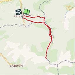
![](/images/other/stat-length.png)
![Excursión Raquetas de nieve Boutx - SR-Cap-de-Gauch - Photo](https://media.geolcdn.com/t/1900/400/ext.pjpeg?maxdim=2&url=https%3A%2F%2Fstatic1.geolcdn.com%2Fsiteimages%2Fupload%2Ffiles%2F1524743153raquette.jpg)
SR-Cap-de-Gauch
Polo-31
Usuario
![Longitud](/images/other/stat-length.png)
![Altitud máxima](https://static1.geolcdn.com/siteimages/upload/files/1508320355ic_sort_altitude_max_24dp.png)
![Desnivel positivo](https://static1.geolcdn.com/siteimages/upload/files/1508320355ic_sort_den_pos_24dp.png)
![Km-Effort](/images/other/stat-length.png)
![Altitud mínima](https://static1.geolcdn.com/siteimages/upload/files/1508320355ic_sort_altitude_min_24dp.png)
![Desnivel negativo](https://static1.geolcdn.com/siteimages/upload/files/1508320355ic_sort_den_neg_24dp.png)
![Boucle](https://static1.geolcdn.com/siteimages/upload/files/16400158638029165_repeat_loop_refresh_sync_direction_icon.png)
![Raquetas de nieve](https://static1.geolcdn.com/sitytour/trail-icons/504.png)
6h15
Dificultad : Difícil
![Escanee este código QR para abrir la excursión en la aplicación SityTrail](https://capi.geolives.com/qq0zvz2zws4bq2lad0pu/sitytour/trails/695989/qr.png?size=200)
Aplicación GPS de excursión GRATIS
A propósito
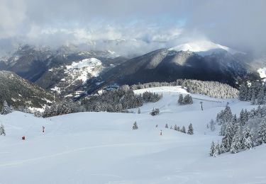
Ruta Raquetas de nieve de 13,3 km a descubrir en Occitania, Alto-Garona, Boutx. Esta ruta ha sido propuesta por Polo-31.
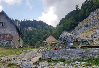
Descripción
Le Couéou (893m).
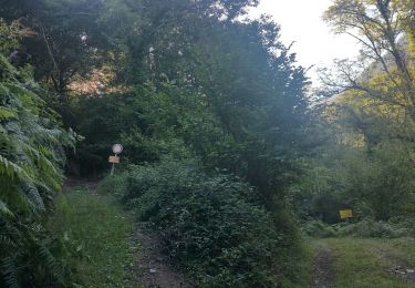
Suivre le sentier qui part à gauche, parallèle à la route (direction "Le Piéjau").
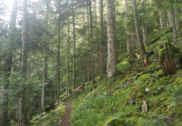
Il bifurque rapidement vers l'Est et rejoint le GR de pays dont on suit désormais le balisage jaune et rouge. Après une longue traversée vers l'Est, puis une montée en lacet dans les bois on rejoint le col de Piéjau (1453m).
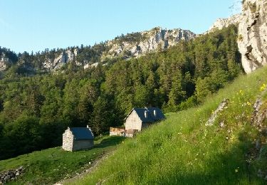
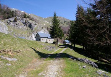
Continuer sur le GR (direction Sud) pour rejoindre rapidement la jolie cabane forestière du Piéjau.
1h30 Cabane forestière de Piéjau (1456m).
Poursuivre à découvert dans la même direction.
Vers la cote 1554m noter sur la droite la crête qu'on empruntera au retour.
Le sentier passe à droite du Tucole de Paillère (1724m) et poursuit sa montée toujours vers le Sud jusqu'au Pas de Peyre Nère.
2h50 Pas de Peyre Nère (1860m).
On laisse le GR qui part à gauche, et on poursuit la longue montée vers le Sud en direction du Cap de Gauch.
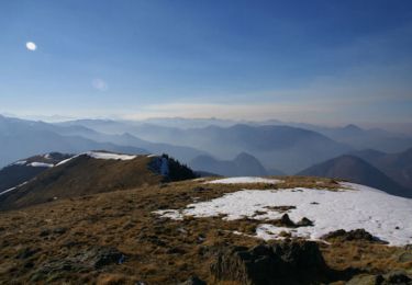
3h45 Cap de Gauch (2148m)Les 20 derniers mètres se font sur une arête assez aérienne.
En cas de doute, renoncer sans regret à effectuer ce bref parcours final qui n'apportera rien de plus au niveau de la vue.
Revenir par le même itinéraire jusque vers la côte 1554m (notée plus haut)
5h00 Côte 1554m
Descendre à gauche (Ouest) sur la large crête que l'on garde jusqu'au bout. Cet itinéraire en partie hors sentier et peu évident, de bonnes connaissances en orientation sont nécessaires.
En cas de doute, préférer revenir par l'itinéraire de l'aller.
6h15 Le Couedou (893m).
Localización
Comentarios
Excursiones cerca
![Excursión Senderismo Boutx - Cagire - Photo](https://media.geolcdn.com/t/375/260/ext.jpg?maxdim=2&url=https%3A%2F%2Fstatic1.geolcdn.com%2Fsiteimages%2Fupload%2Ffiles%2F1553511878bg_sport_marche.png)
![Senderismo Senderismo](https://static1.geolcdn.com/sitytour/trail-icons/101.png)
Senderismo
![](/images/other/stat-length.png)
![](https://static1.geolcdn.com/siteimages/upload/files/16400158638029165_repeat_loop_refresh_sync_direction_icon.png)
![Excursión Senderismo Portet-d'Aspet - 2023 09 21 CHEMIN du PIÉMONT PYRÉNÉEN - 14ème étape : Portet-d’Aspet - le Col - Juzet-d’Izaut - St Pet-d’Ardet - Barbazan - Valcabrère - st Bertrand de Comminges - Photo](https://media.geolcdn.com/t/375/260/aef99e2b-7039-4bd2-8756-4eb0da2534bf.jpg&format=jpg&maxdim=2)
![Senderismo Senderismo](https://static1.geolcdn.com/sitytour/trail-icons/101.png)
Senderismo
![](/images/other/stat-length.png)
![](https://static1.geolcdn.com/siteimages/upload/files/16400158638029165_repeat_loop_refresh_sync_direction_icon.png)
![Excursión Senderismo Fos - Cap des Hittes en boucle - Photo](https://media.geolcdn.com/t/375/260/1e4b7e6c-6350-44c3-93da-faae8ca0db7c.jpg&format=jpg&maxdim=2)
![Senderismo Senderismo](https://static1.geolcdn.com/sitytour/trail-icons/101.png)
Senderismo
![](/images/other/stat-length.png)
![](https://static1.geolcdn.com/siteimages/upload/files/16400158638029165_repeat_loop_refresh_sync_direction_icon.png)
![Excursión Senderismo Saint-Lary - pic de la Calabasse en boucles depuis le parking de l'Osque Couret - Photo](https://media.geolcdn.com/t/375/260/b5877bf4-d685-460d-a4d6-ae49b9effbcd.jpg&format=jpg&maxdim=2)
![Senderismo Senderismo](https://static1.geolcdn.com/sitytour/trail-icons/101.png)
Senderismo
![](/images/other/stat-length.png)
![](https://static1.geolcdn.com/siteimages/upload/files/16400158638029165_repeat_loop_refresh_sync_direction_icon.png)
![Excursión Senderismo Sengouagnet - LARREIX à CAGIRE - Rando avec Léo 5ans - Photo](https://media.geolcdn.com/t/375/260/487361f6-4f62-4062-b989-4c5e5cd66feb.jpg&format=jpg&maxdim=2)
![Senderismo Senderismo](https://static1.geolcdn.com/sitytour/trail-icons/101.png)
Senderismo
![](/images/other/stat-length.png)
![](https://static1.geolcdn.com/siteimages/upload/files/16400158638029165_repeat_loop_refresh_sync_direction_icon.png)
![Excursión Senderismo Boutx - col de Mente-Larreix-Cagire-Escalette-retour - Photo](https://media.geolcdn.com/t/375/260/ext.jpg?maxdim=2&url=https%3A%2F%2Fservices.sitytrail.com%2FGeolivesWS%2FDownloadMedia.ashx%3FTrailID%3D580671%26Media%3Dfix__20160606072446.jpg)
![Senderismo Senderismo](https://static1.geolcdn.com/sitytour/trail-icons/101.png)
Senderismo
![](/images/other/stat-length.png)
![](https://static1.geolcdn.com/siteimages/upload/files/16400158638029165_repeat_loop_refresh_sync_direction_icon.png)
![Excursión Senderismo Boutx - Tuc de l'Etang et Pic d'Escales - Photo](https://media.geolcdn.com/t/375/260/ext.jpg?maxdim=2&url=https%3A%2F%2Fservices.sitytrail.com%2FGeolivesWS%2FDownloadMedia.ashx%3FTrailID%3D109653%26Media%3D4294_5.jpg)
![Senderismo Senderismo](https://static1.geolcdn.com/sitytour/trail-icons/101.png)
Senderismo
![](/images/other/stat-length.png)
![](https://static1.geolcdn.com/siteimages/upload/files/16400158638029165_repeat_loop_refresh_sync_direction_icon.png)
![Excursión Senderismo Boutx - Pic de Cagire - Photo](https://media.geolcdn.com/t/375/260/ext.jpg?maxdim=2&url=https%3A%2F%2Fservices.sitytrail.com%2FGeolivesWS%2FDownloadMedia.ashx%3FTrailID%3D109651%26Media%3D4292_1.jpg)
![Senderismo Senderismo](https://static1.geolcdn.com/sitytour/trail-icons/101.png)
Senderismo
![](/images/other/stat-length.png)
![](https://static1.geolcdn.com/siteimages/upload/files/16400158638029165_repeat_loop_refresh_sync_direction_icon.png)
![Excursión Senderismo Boutx - Tuc de l'Etang depuis Le Mourtis - Photo](https://media.geolcdn.com/t/375/260/b0477d44-8d8e-4a5f-a32f-3371e26789c2.jpg&format=jpg&maxdim=2)
![Senderismo Senderismo](https://static1.geolcdn.com/sitytour/trail-icons/101.png)
Senderismo
![](/images/other/stat-length.png)
![](https://static1.geolcdn.com/siteimages/upload/files/16400158638029165_repeat_loop_refresh_sync_direction_icon.png)