![](/images/other/stat-length.png)
![Excursión Senderismo Queige - Le sentier de la mémoire - Les Pointières - Photo](https://media.geolcdn.com/t/1900/400/ext.pjpeg?maxdim=2&url=https%3A%2F%2Fstatic1.geolcdn.com%2Fsiteimages%2Fupload%2Ffiles%2F1553511878bg_sport_marche.png)
Le sentier de la mémoire - Les Pointières
Desrumaux
Usuario GUIDE
![Longitud](/images/other/stat-length.png)
Longitud
5,1 km
![Altitud máxima](https://static1.geolcdn.com/siteimages/upload/files/1508320355ic_sort_altitude_max_24dp.png)
Altitud máxima
1216 m
![Desnivel positivo](https://static1.geolcdn.com/siteimages/upload/files/1508320355ic_sort_den_pos_24dp.png)
Desnivel positivo
283 m
![Km-Effort](/images/other/stat-length.png)
Km-Effort
8,9 km
![Altitud mínima](https://static1.geolcdn.com/siteimages/upload/files/1508320355ic_sort_altitude_min_24dp.png)
Altitud mínima
947 m
![Desnivel negativo](https://static1.geolcdn.com/siteimages/upload/files/1508320355ic_sort_den_neg_24dp.png)
Desnivel negativo
278 m
![Boucle](https://static1.geolcdn.com/siteimages/upload/files/16400158638029165_repeat_loop_refresh_sync_direction_icon.png)
Boucle
Sí
Fecha de creación :
2014-12-10 00:00:00.0
Última modificación :
2014-12-10 00:00:00.0
![Senderismo](https://static1.geolcdn.com/sitytour/trail-icons/101.png)
3h00
Dificultad : Fácil
![Escanee este código QR para abrir la excursión en la aplicación SityTrail](https://capi.geolives.com/qq0zvz2zws4bq2lad0pu/sitytour/trails/69250/qr.png?size=200)
Aplicación GPS de excursión GRATIS
A propósito
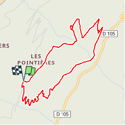
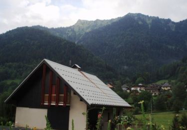
Ruta Senderismo de 5,1 km a descubrir en Auvergne-Rhône-Alpes, Saboya, Queige. Esta ruta ha sido propuesta por Desrumaux.
Descripción
Détails de la rando sur TraceGPS.com
http://www.tracegps.com/fr/parcours/circuit11530.htm
Localización
País:
France
Región :
Auvergne-Rhône-Alpes
Departamento/provincia :
Saboya
Municipio :
Queige
Localidad:
Unknown
Salida:(Dec)
Salida:(UTM)
300360 ; 5063422 (32T) N.
Comentarios
Excursiones cerca
![Excursión Senderismo Queige - Le sentier de la mémoire - Les Pointières - Photo](https://media.geolcdn.com/t/375/260/ext.jpg?maxdim=2&url=https%3A%2F%2Fservices.sitytrail.com%2FGeolivesWS%2FDownloadMedia.ashx%3FTrailID%3D112686%26Media%3D11530_5.jpg)
![Senderismo Senderismo](https://static1.geolcdn.com/sitytour/trail-icons/101.png)
Le sentier de la mémoire - Les Pointières
Senderismo
Medio
(1)
Queige,
Auvergne-Rhône-Alpes,
Saboya,
France
![](/images/other/stat-length.png)
5,1 km | 8,9 km-effort
3h 0min
![](https://static1.geolcdn.com/siteimages/upload/files/16400158638029165_repeat_loop_refresh_sync_direction_icon.png)
Sí
![Excursión Senderismo Queige - suuntoapp-Hiking-2024-09-06T06-04-43Z - Photo](https://media.geolcdn.com/t/375/260/f3e89b8c-3c97-4299-aeda-1fcf18be7990.jpg&format=jpg&maxdim=2)
![Senderismo Senderismo](https://static1.geolcdn.com/sitytour/trail-icons/101.png)
suuntoapp-Hiking-2024-09-06T06-04-43Z
Senderismo
Muy difícil
Queige,
Auvergne-Rhône-Alpes,
Saboya,
France
![](/images/other/stat-length.png)
15,1 km | 32 km-effort
7h 22min
![](https://static1.geolcdn.com/siteimages/upload/files/16400158638029165_repeat_loop_refresh_sync_direction_icon.png)
No
![Excursión Senderismo Marthod - Santier botanique - Photo](https://media.geolcdn.com/t/375/260/c3ed3ef9-14f9-4ca9-a64b-14164707e877.jpg&format=jpg&maxdim=2)
![Senderismo Senderismo](https://static1.geolcdn.com/sitytour/trail-icons/101.png)
Santier botanique
Senderismo
Difícil
Marthod,
Auvergne-Rhône-Alpes,
Saboya,
France
![](/images/other/stat-length.png)
7,3 km | 12 km-effort
2h 49min
![](https://static1.geolcdn.com/siteimages/upload/files/16400158638029165_repeat_loop_refresh_sync_direction_icon.png)
Sí
![Excursión Bicicleta Albertville - Hardy L'Arly - Photo](https://media.geolcdn.com/t/375/260/ext.jpg?maxdim=2&url=https%3A%2F%2Fservices.sitytrail.com%2FGeolivesWS%2FDownloadMedia.ashx%3FTrailID%3D134775%26Media%3D59e07ac4-0a90-4777-a7cc-621c74e43c59.jpg)
![Bicicleta Bicicleta](https://static1.geolcdn.com/sitytour/trail-icons/200.png)
Hardy L'Arly
Bicicleta
Difícil
Albertville,
Auvergne-Rhône-Alpes,
Saboya,
France
![](/images/other/stat-length.png)
45 km | 65 km-effort
Desconocido
![](https://static1.geolcdn.com/siteimages/upload/files/16400158638029165_repeat_loop_refresh_sync_direction_icon.png)
No
![Excursión Raquetas de nieve Queige - Le Haut du Pré depuis le parking des Croix - Photo](https://media.geolcdn.com/t/375/260/40db71ab-b2eb-4294-a255-1a7ab8f8b4e8.jpg&format=jpg&maxdim=2)
![Raquetas de nieve Raquetas de nieve](https://static1.geolcdn.com/sitytour/trail-icons/504.png)
Le Haut du Pré depuis le parking des Croix
Raquetas de nieve
Medio
Queige,
Auvergne-Rhône-Alpes,
Saboya,
France
![](/images/other/stat-length.png)
7,1 km | 14,5 km-effort
2h 42min
![](https://static1.geolcdn.com/siteimages/upload/files/16400158638029165_repeat_loop_refresh_sync_direction_icon.png)
Sí
![Excursión Senderismo Albertville - alberville - Photo](https://media.geolcdn.com/t/375/260/d0d2962d-135f-4879-8d0e-d5009494617f.jpg&format=jpg&maxdim=2)
![Senderismo Senderismo](https://static1.geolcdn.com/sitytour/trail-icons/101.png)
alberville
Senderismo
Muy fácil
Albertville,
Auvergne-Rhône-Alpes,
Saboya,
France
![](/images/other/stat-length.png)
10,8 km | 22 km-effort
6h 37min
![](https://static1.geolcdn.com/siteimages/upload/files/16400158638029165_repeat_loop_refresh_sync_direction_icon.png)
Sí
![Excursión Senderismo Queige - La Roche Pourrie depuis les Chappes - Photo](https://media.geolcdn.com/t/375/260/ext.jpg?maxdim=2&url=https%3A%2F%2Fservices.sitytrail.com%2FGeolivesWS%2FDownloadMedia.ashx%3FTrailID%3D172914%26Media%3D14376_1.jpg)
![Senderismo Senderismo](https://static1.geolcdn.com/sitytour/trail-icons/101.png)
La Roche Pourrie depuis les Chappes
Senderismo
Difícil
Queige,
Auvergne-Rhône-Alpes,
Saboya,
France
![](/images/other/stat-length.png)
4,3 km | 10,3 km-effort
3h 4min
![](https://static1.geolcdn.com/siteimages/upload/files/16400158638029165_repeat_loop_refresh_sync_direction_icon.png)
Sí
![Excursión Senderismo Venthon - Traversée de la Roche Pourrie, Mont Mirantin, 2460m - Photo](https://media.geolcdn.com/t/375/260/ext.jpg?maxdim=2&url=https%3A%2F%2Fservices.sitytrail.com%2FGeolivesWS%2FDownloadMedia.ashx%3FTrailID%3D172720%26Media%3D14106_1.jpg)
![Senderismo Senderismo](https://static1.geolcdn.com/sitytour/trail-icons/101.png)
Traversée de la Roche Pourrie, Mont Mirantin, 2460m
Senderismo
Difícil
Venthon,
Auvergne-Rhône-Alpes,
Saboya,
France
![](/images/other/stat-length.png)
15,4 km | 33 km-effort
9h 30min
![](https://static1.geolcdn.com/siteimages/upload/files/16400158638029165_repeat_loop_refresh_sync_direction_icon.png)
Sí
![Excursión Senderismo Albertville - D'Albertville à Thônes 1/4 - Autour de la Belle Etoile - Photo](https://media.geolcdn.com/t/375/260/ext.jpg?maxdim=2&url=https%3A%2F%2Fservices.sitytrail.com%2FGeolivesWS%2FDownloadMedia.ashx%3FTrailID%3D109630%26Media%3D4271_1.jpg)
![Senderismo Senderismo](https://static1.geolcdn.com/sitytour/trail-icons/101.png)
D'Albertville à Thônes 1/4 - Autour de la Belle Etoile
Senderismo
Difícil
Albertville,
Auvergne-Rhône-Alpes,
Saboya,
France
![](/images/other/stat-length.png)
18 km | 32 km-effort
6h 30min
![](https://static1.geolcdn.com/siteimages/upload/files/16400158638029165_repeat_loop_refresh_sync_direction_icon.png)
No