![](/images/other/stat-length.png)
![Excursión Senderismo Villey-Saint-Étienne - Villey st Etienne - Photo](https://media.geolcdn.com/t/1900/400/ext.pjpeg?maxdim=2&url=https%3A%2F%2Fservices.sitytrail.com%2FGeolivesWS%2FDownloadMedia.ashx%3FTrailID%3D689892%26Media%3D20170126161830.jpg)
Villey st Etienne
australys
Usuario
![Longitud](/images/other/stat-length.png)
![Altitud máxima](https://static1.geolcdn.com/siteimages/upload/files/1508320355ic_sort_altitude_max_24dp.png)
![Desnivel positivo](https://static1.geolcdn.com/siteimages/upload/files/1508320355ic_sort_den_pos_24dp.png)
![Km-Effort](/images/other/stat-length.png)
![Altitud mínima](https://static1.geolcdn.com/siteimages/upload/files/1508320355ic_sort_altitude_min_24dp.png)
![Desnivel negativo](https://static1.geolcdn.com/siteimages/upload/files/1508320355ic_sort_den_neg_24dp.png)
![Boucle](https://static1.geolcdn.com/siteimages/upload/files/16400158638029165_repeat_loop_refresh_sync_direction_icon.png)
![Senderismo](https://static1.geolcdn.com/sitytour/trail-icons/101.png)
2h20
Dificultad : Fácil
![Escanee este código QR para abrir la excursión en la aplicación SityTrail](https://capi.geolives.com/qq0zvz2zws4bq2lad0pu/sitytour/trails/689892/qr.png?size=200)
Aplicación GPS de excursión GRATIS
A propósito
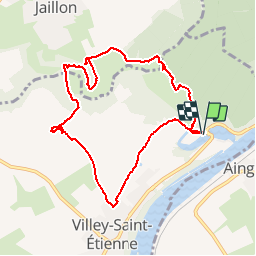
Ruta Senderismo de 8,9 km a descubrir en Gran Este, Meurthe y Mosela, Villey-Saint-Étienne. Esta ruta ha sido propuesta por australys.
Descripción
Balade sympa autour de Villey- saint- Etienne et Jaillon.
Le Terrouin sinue dans une vallée étroite total de 24 kilomètres. Les Communes concernées sont Trondes, Lagney, Sanzey, Ménil la Tour, Andilly, Manoncourt en Woëvre, Avrainville, Jaillon et Villey St Etienne
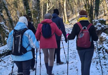
vallée sauvage et préservée, castor d’Europe, chat sauvage, martin-pêcheur, héron cendré, grenouille verte et rainette, couleuvre à collier…
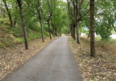
Milieux naturels : zones humides, anciennes carrières, pelouses calcaire
, bonne balade.
Localización
Comentarios
Excursiones cerca
![Excursión Senderismo Liverdun - Liverdun - La grande boucle de Natrou - Photo](https://media.geolcdn.com/t/375/260/5dac390e-3606-42c9-8130-3aab112c0eaf.jpg&format=jpg&maxdim=2)
![Senderismo Senderismo](https://static1.geolcdn.com/sitytour/trail-icons/101.png)
Senderismo
![](/images/other/stat-length.png)
![](https://static1.geolcdn.com/siteimages/upload/files/16400158638029165_repeat_loop_refresh_sync_direction_icon.png)
![Excursión A pie Jaillon - Circuit de Jaillon - Photo](https://media.geolcdn.com/t/375/260/2676c367-543f-4a9f-9348-cc04c26dbf9c.jpeg&format=jpg&maxdim=2)
![A pie A pie](https://static1.geolcdn.com/sitytour/trail-icons/100.png)
A pie
![](/images/other/stat-length.png)
![](https://static1.geolcdn.com/siteimages/upload/files/16400158638029165_repeat_loop_refresh_sync_direction_icon.png)
![Excursión A pie Jaillon - Sentier de découverte de la vallée du Terrouin - Photo](https://media.geolcdn.com/t/375/260/6e52721f-5d1e-4b30-b153-0ca1b0f0f7e0.jpeg&format=jpg&maxdim=2)
![A pie A pie](https://static1.geolcdn.com/sitytour/trail-icons/100.png)
A pie
![](/images/other/stat-length.png)
![](https://static1.geolcdn.com/siteimages/upload/files/16400158638029165_repeat_loop_refresh_sync_direction_icon.png)
![Excursión Bici de carretera Liverdun - 2020 09 03 Nancy par voie vélo - Photo](https://media.geolcdn.com/t/375/260/c3ac8dd3-f654-4ba5-8ff7-ab3c7408e6de.jpg&format=jpg&maxdim=2)
![Bici de carretera Bici de carretera](https://static1.geolcdn.com/sitytour/trail-icons/201.png)
Bici de carretera
![](/images/other/stat-length.png)
![](https://static1.geolcdn.com/siteimages/upload/files/16400158638029165_repeat_loop_refresh_sync_direction_icon.png)
![Excursión Senderismo Toul - TOUL - LA CROIX D'ARGENT - Photo](https://media.geolcdn.com/t/375/260/e3f1b75b-7d57-4344-812a-03d7abcb3a24.jpg&format=jpg&maxdim=2)
![Senderismo Senderismo](https://static1.geolcdn.com/sitytour/trail-icons/101.png)
Senderismo
![](/images/other/stat-length.png)
![](https://static1.geolcdn.com/siteimages/upload/files/16400158638029165_repeat_loop_refresh_sync_direction_icon.png)
![Excursión Senderismo Villey-Saint-Étienne - Villette st etienne - Photo](https://media.geolcdn.com/t/375/260/2352cc63-2e96-489a-8cbc-64ad8b8f96c9.jpg&format=jpg&maxdim=2)
![Senderismo Senderismo](https://static1.geolcdn.com/sitytour/trail-icons/101.png)
Senderismo
![](/images/other/stat-length.png)
![](https://static1.geolcdn.com/siteimages/upload/files/16400158638029165_repeat_loop_refresh_sync_direction_icon.png)
![Excursión Senderismo Liverdun - foret de Natrou & vallée de la Moselle avec barrage de la Marne au Rhin avec l écluse - Photo](https://media.geolcdn.com/t/375/260/ext.jpg?maxdim=2&url=https%3A%2F%2Fservices.sitytrail.com%2FGeolivesWS%2FDownloadMedia.ashx%3FTrailID%3D688485%26Media%3D20170123164830.jpg)
![Senderismo Senderismo](https://static1.geolcdn.com/sitytour/trail-icons/101.png)
Senderismo
![](/images/other/stat-length.png)
![](https://static1.geolcdn.com/siteimages/upload/files/16400158638029165_repeat_loop_refresh_sync_direction_icon.png)
![Excursión Senderismo Fontenoy-sur-Moselle - Fontenoy Bois Essarte - Photo](https://media.geolcdn.com/t/375/260/4359d1d1-83dd-4b3d-af28-6cc3aecfbb92.jpg&format=jpg&maxdim=2)
![Senderismo Senderismo](https://static1.geolcdn.com/sitytour/trail-icons/101.png)
Senderismo
![](/images/other/stat-length.png)
![](https://static1.geolcdn.com/siteimages/upload/files/16400158638029165_repeat_loop_refresh_sync_direction_icon.png)
![Excursión A pie Villey-Saint-Étienne - Circuit Sous les charmes du Vieux Canton - Photo](https://media.geolcdn.com/t/375/260/51bd65e3-ea13-47ab-ac3b-5cb9d4a6128a.jpeg&format=jpg&maxdim=2)
![A pie A pie](https://static1.geolcdn.com/sitytour/trail-icons/100.png)
A pie
![](/images/other/stat-length.png)
![](https://static1.geolcdn.com/siteimages/upload/files/16400158638029165_repeat_loop_refresh_sync_direction_icon.png)