![](/images/other/stat-length.png)
![Excursión Senderismo Ceaulmont - Le circuit du Val de Creuse - Photo](https://media.geolcdn.com/t/1900/400/ext.pjpeg?maxdim=2&url=https%3A%2F%2Fstatic1.geolcdn.com%2Fsiteimages%2Fupload%2Ffiles%2F1553511878bg_sport_marche.png)
Le circuit du Val de Creuse
Phil36
Usuario
![Longitud](/images/other/stat-length.png)
Longitud
15,1 km
![Altitud máxima](https://static1.geolcdn.com/siteimages/upload/files/1508320355ic_sort_altitude_max_24dp.png)
Altitud máxima
248 m
![Desnivel positivo](https://static1.geolcdn.com/siteimages/upload/files/1508320355ic_sort_den_pos_24dp.png)
Desnivel positivo
215 m
![Km-Effort](/images/other/stat-length.png)
Km-Effort
18 km
![Altitud mínima](https://static1.geolcdn.com/siteimages/upload/files/1508320355ic_sort_altitude_min_24dp.png)
Altitud mínima
121 m
![Desnivel negativo](https://static1.geolcdn.com/siteimages/upload/files/1508320355ic_sort_den_neg_24dp.png)
Desnivel negativo
215 m
![Boucle](https://static1.geolcdn.com/siteimages/upload/files/16400158638029165_repeat_loop_refresh_sync_direction_icon.png)
Boucle
Sí
Fecha de creación :
2017-03-23 00:00:00.0
Última modificación :
2017-03-23 00:00:00.0
![Senderismo](https://static1.geolcdn.com/sitytour/trail-icons/101.png)
3h55
Dificultad : Medio
![Escanee este código QR para abrir la excursión en la aplicación SityTrail](https://capi.geolives.com/qq0zvz2zws4bq2lad0pu/sitytour/trails/684883/qr.png?size=200)
Aplicación GPS de excursión GRATIS
A propósito
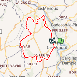
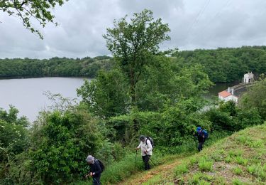
Ruta Senderismo de 15,1 km a descubrir en Centro, Indre, Ceaulmont. Esta ruta ha sido propuesta por Phil36.
Descripción
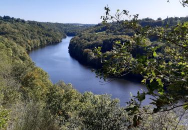
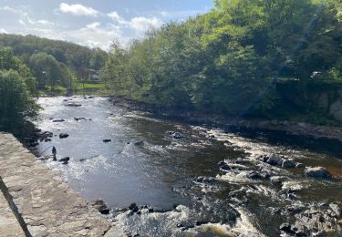
Riveraine de la Creuse sur une quinzaine de kilomètres entre le pont Noir et le Vivier, la commune de Ceaulmont compte de nombreux moulins hérités de l'exploitation de l'énergie hydroulique.
Localización
País:
France
Región :
Centro
Departamento/provincia :
Indre
Municipio :
Ceaulmont
Localidad:
Unknown
Salida:(Dec)
Salida:(UTM)
391036 ; 5153172 (31T) N.
Comentarios
Excursiones cerca
![Excursión Senderismo Gargilesse-Dampierre - SityTrail - La Chaumerette,Gargilesse - Photo](https://media.geolcdn.com/t/375/260/ext.jpg?maxdim=2&url=https%3A%2F%2Fstatic1.geolcdn.com%2Fsiteimages%2Fupload%2Ffiles%2F1553511878bg_sport_marche.png)
![Senderismo Senderismo](https://static1.geolcdn.com/sitytour/trail-icons/101.png)
SityTrail - La Chaumerette,Gargilesse
Senderismo
Muy difícil
(1)
Gargilesse-Dampierre,
Centro,
Indre,
France
![](/images/other/stat-length.png)
15,8 km | 19,7 km-effort
4h 28min
![](https://static1.geolcdn.com/siteimages/upload/files/16400158638029165_repeat_loop_refresh_sync_direction_icon.png)
Sí
![Excursión A pie Gargilesse-Dampierre - La Gargilesse secrète et sauvage - Photo](https://media.geolcdn.com/t/375/260/f45fabfe-9f8e-4791-bb71-f646d5039a7b.jpeg&format=jpg&maxdim=2)
![A pie A pie](https://static1.geolcdn.com/sitytour/trail-icons/100.png)
La Gargilesse secrète et sauvage
A pie
Fácil
Gargilesse-Dampierre,
Centro,
Indre,
France
![](/images/other/stat-length.png)
6,7 km | 8,3 km-effort
1h 53min
![](https://static1.geolcdn.com/siteimages/upload/files/16400158638029165_repeat_loop_refresh_sync_direction_icon.png)
No
![Excursión Senderismo Gargilesse-Dampierre - Compostelle etape 13 - Photo](https://media.geolcdn.com/t/375/260/392da69d-726a-4863-8547-359569904a75.jpg&format=jpg&maxdim=2)
![Senderismo Senderismo](https://static1.geolcdn.com/sitytour/trail-icons/101.png)
Compostelle etape 13
Senderismo
Difícil
Gargilesse-Dampierre,
Centro,
Indre,
France
![](/images/other/stat-length.png)
29 km | 39 km-effort
9h 58min
![](https://static1.geolcdn.com/siteimages/upload/files/16400158638029165_repeat_loop_refresh_sync_direction_icon.png)
No
![Excursión Senderismo Gargilesse-Dampierre - Beau parcours au départ du moulin de Gargilesse - Photo](https://media.geolcdn.com/t/375/260/fa1c368f-74d0-46db-8d60-0af1fbae6602.jpg&format=jpg&maxdim=2)
![Senderismo Senderismo](https://static1.geolcdn.com/sitytour/trail-icons/101.png)
Beau parcours au départ du moulin de Gargilesse
Senderismo
Muy fácil
Gargilesse-Dampierre,
Centro,
Indre,
France
![](/images/other/stat-length.png)
16,2 km | 21 km-effort
3h 48min
![](https://static1.geolcdn.com/siteimages/upload/files/16400158638029165_repeat_loop_refresh_sync_direction_icon.png)
Sí
![Excursión Bici de montaña Le Menoux - Vallée de la Creuse 1 - Photo](https://media.geolcdn.com/t/375/260/ext.jpg?maxdim=2&url=https%3A%2F%2Fstatic1.geolcdn.com%2Fsiteimages%2Fupload%2Ffiles%2F1524743154velo.jpg)
![Bici de montaña Bici de montaña](https://static1.geolcdn.com/sitytour/trail-icons/202.png)
Vallée de la Creuse 1
Bici de montaña
Medio
(1)
Le Menoux,
Centro,
Indre,
France
![](/images/other/stat-length.png)
51 km | 63 km-effort
Desconocido
![](https://static1.geolcdn.com/siteimages/upload/files/16400158638029165_repeat_loop_refresh_sync_direction_icon.png)
No
![Excursión Senderismo Gargilesse-Dampierre - La chaumerette pont des piles - Photo](https://media.geolcdn.com/t/375/260/c178561a-edbd-4064-b2a7-0ed1ebb39ac8.jpg&format=jpg&maxdim=2)
![Senderismo Senderismo](https://static1.geolcdn.com/sitytour/trail-icons/101.png)
La chaumerette pont des piles
Senderismo
Difícil
Gargilesse-Dampierre,
Centro,
Indre,
France
![](/images/other/stat-length.png)
22 km | 27 km-effort
5h 28min
![](https://static1.geolcdn.com/siteimages/upload/files/16400158638029165_repeat_loop_refresh_sync_direction_icon.png)
Sí
![Excursión sport Le Menoux - Sob 17 le menoux cuzion - Photo](https://media.geolcdn.com/t/375/260/a7ea09a4-f376-4dab-a4f6-85126f46f916.jpg&format=jpg&maxdim=2)
Sob 17 le menoux cuzion
sport
Muy fácil
Le Menoux,
Centro,
Indre,
France
![](/images/other/stat-length.png)
16,6 km | 21 km-effort
Desconocido
![](https://static1.geolcdn.com/siteimages/upload/files/16400158638029165_repeat_loop_refresh_sync_direction_icon.png)
No
![Excursión Senderismo Cuzion - Cuzion - Photo](https://media.geolcdn.com/t/375/260/b03cf623-7ff8-4acd-94ea-f6c2044c2cbd.jpg&format=jpg&maxdim=2)
![Senderismo Senderismo](https://static1.geolcdn.com/sitytour/trail-icons/101.png)
![Excursión Senderismo Gargilesse-Dampierre - 1 er rando - Photo](https://media.geolcdn.com/t/375/260/ext.jpg?maxdim=2&url=https%3A%2F%2Fstatic1.geolcdn.com%2Fsiteimages%2Fupload%2Ffiles%2F1553511878bg_sport_marche.png)
![Senderismo Senderismo](https://static1.geolcdn.com/sitytour/trail-icons/101.png)
1 er rando
Senderismo
Muy difícil
Gargilesse-Dampierre,
Centro,
Indre,
France
![](/images/other/stat-length.png)
16,9 km | 20 km-effort
3h 58min
![](https://static1.geolcdn.com/siteimages/upload/files/16400158638029165_repeat_loop_refresh_sync_direction_icon.png)
Sí