![](/images/other/stat-length.png)
![Excursión Senderismo Borne - GR7 E08 LeBez-LaBastidePuyLaurent - Photo](https://media.geolcdn.com/t/1900/400/ext.pjpeg?maxdim=2&url=https%3A%2F%2Fstatic1.geolcdn.com%2Fsiteimages%2Fupload%2Ffiles%2F1553511878bg_sport_marche.png)
GR7 E08 LeBez-LaBastidePuyLaurent
richard21220
Usuario
![Longitud](/images/other/stat-length.png)
![Altitud máxima](https://static1.geolcdn.com/siteimages/upload/files/1508320355ic_sort_altitude_max_24dp.png)
![Desnivel positivo](https://static1.geolcdn.com/siteimages/upload/files/1508320355ic_sort_den_pos_24dp.png)
![Km-Effort](/images/other/stat-length.png)
![Altitud mínima](https://static1.geolcdn.com/siteimages/upload/files/1508320355ic_sort_altitude_min_24dp.png)
![Desnivel negativo](https://static1.geolcdn.com/siteimages/upload/files/1508320355ic_sort_den_neg_24dp.png)
![Boucle](https://static1.geolcdn.com/siteimages/upload/files/16400158638029165_repeat_loop_refresh_sync_direction_icon.png)
![Senderismo](https://static1.geolcdn.com/sitytour/trail-icons/101.png)
4h59
Dificultad : Fácil
![Escanee este código QR para abrir la excursión en la aplicación SityTrail](https://capi.geolives.com/qq0zvz2zws4bq2lad0pu/sitytour/trails/680793/qr.png?size=200)
Aplicación GPS de excursión GRATIS
A propósito
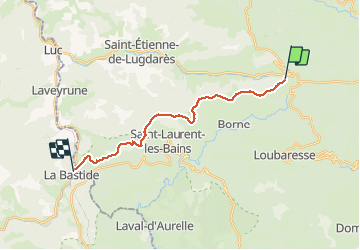
Ruta Senderismo de 17,1 km a descubrir en Auvergne-Rhône-Alpes, Ardecha, Borne. Esta ruta ha sido propuesta por richard21220.
Descripción
Hôtel Restaurant Les Genêts : 48250 LA BASTIDE PUYLAURENT Tél 04 66 46 00 13
Hôtel Restaurant de la Grande Halte : Rue des Tilleuls 48250 LA BASTIDE PUYLAURENT Tél 04 66 46 00 35
Maison d'Hôtes L'Etoile : 48250 LA BASTIDE PUYLAURENT Tél 04 66 46 05 52
Localización
Comentarios
Excursiones cerca
![Excursión Senderismo Borne - croix de beauzon - Photo](https://media.geolcdn.com/t/375/260/217677dd-c155-48af-bc87-419b5b32c8ce.jpg&format=jpg&maxdim=2)
![Senderismo Senderismo](https://static1.geolcdn.com/sitytour/trail-icons/101.png)
Senderismo
![](/images/other/stat-length.png)
![](https://static1.geolcdn.com/siteimages/upload/files/16400158638029165_repeat_loop_refresh_sync_direction_icon.png)
![Excursión Senderismo Valgorge - Le Tanargue - Photo](https://media.geolcdn.com/t/375/260/ad0e721e-bf17-4b50-b28e-4b195a037c98.jpg&format=jpg&maxdim=2)
![Senderismo Senderismo](https://static1.geolcdn.com/sitytour/trail-icons/101.png)
Senderismo
![](/images/other/stat-length.png)
![](https://static1.geolcdn.com/siteimages/upload/files/16400158638029165_repeat_loop_refresh_sync_direction_icon.png)
![Excursión Senderismo Loubaresse - Loubaresse ruisseau de goutelles 10 km - Photo](https://media.geolcdn.com/t/375/260/7fb7aff1-6923-41f8-900d-5aa3bb3bfe91.jpg&format=jpg&maxdim=2)
![Senderismo Senderismo](https://static1.geolcdn.com/sitytour/trail-icons/101.png)
Senderismo
![](/images/other/stat-length.png)
![](https://static1.geolcdn.com/siteimages/upload/files/16400158638029165_repeat_loop_refresh_sync_direction_icon.png)
![Excursión Senderismo Loubaresse - Loubaresse Nord 5,2 km - Photo](https://media.geolcdn.com/t/375/260/5ae50d28-b170-4d44-aab5-94560c77c18b.jpg&format=jpg&maxdim=2)
![Senderismo Senderismo](https://static1.geolcdn.com/sitytour/trail-icons/101.png)
Senderismo
![](/images/other/stat-length.png)
![](https://static1.geolcdn.com/siteimages/upload/files/16400158638029165_repeat_loop_refresh_sync_direction_icon.png)
![Excursión Senderismo Borne - 2023-01-26_14h31m24_Station Croix de Bauzon 14 km.gpx.xml - Photo](https://media.geolcdn.com/t/375/260/186f655e-2b32-453c-b04b-facbcec1469b.jpg&format=jpg&maxdim=2)
![Senderismo Senderismo](https://static1.geolcdn.com/sitytour/trail-icons/101.png)
Senderismo
![](/images/other/stat-length.png)
![](https://static1.geolcdn.com/siteimages/upload/files/16400158638029165_repeat_loop_refresh_sync_direction_icon.png)
![Excursión A pie Mayres - Tour des Poignets 18km - Photo](https://media.geolcdn.com/t/375/260/4695ff56-51f7-439d-a787-0d719ef81c46.jpg&format=jpg&maxdim=2)
![A pie A pie](https://static1.geolcdn.com/sitytour/trail-icons/100.png)
A pie
![](/images/other/stat-length.png)
![](https://static1.geolcdn.com/siteimages/upload/files/16400158638029165_repeat_loop_refresh_sync_direction_icon.png)
![Excursión Senderismo Saint-Étienne-de-Lugdarès - Le Bez-Borne-les Chambons - Photo](https://media.geolcdn.com/t/375/260/84516e8e-4390-46d3-bf0d-44f54607fcbb.jpg&format=jpg&maxdim=2)
![Senderismo Senderismo](https://static1.geolcdn.com/sitytour/trail-icons/101.png)
Senderismo
![](/images/other/stat-length.png)
![](https://static1.geolcdn.com/siteimages/upload/files/16400158638029165_repeat_loop_refresh_sync_direction_icon.png)
![Excursión Senderismo Borne - Vallée de la Borne - Photo](https://media.geolcdn.com/t/375/260/a1b498ea-d1c1-4335-9a23-7d6d1fab4a20.jpg&format=jpg&maxdim=2)
![Senderismo Senderismo](https://static1.geolcdn.com/sitytour/trail-icons/101.png)
Senderismo
![](/images/other/stat-length.png)
![](https://static1.geolcdn.com/siteimages/upload/files/16400158638029165_repeat_loop_refresh_sync_direction_icon.png)
![Excursión Senderismo La Souche - Rocher d'Abraham par la Tour des Poignets - Photo](https://media.geolcdn.com/t/375/260/7fafd23c-0b70-4e8a-8e13-fea6920ba10a.jpg&format=jpg&maxdim=2)
![Senderismo Senderismo](https://static1.geolcdn.com/sitytour/trail-icons/101.png)
Senderismo
![](/images/other/stat-length.png)
![](https://static1.geolcdn.com/siteimages/upload/files/16400158638029165_repeat_loop_refresh_sync_direction_icon.png)