![](/images/other/stat-length.png)
![Excursión Senderismo Linthal - Markstein 29/12/2016 - Photo](https://media.geolcdn.com/t/1900/400/ext.pjpeg?maxdim=2&url=https%3A%2F%2Fservices.sitytrail.com%2FGeolivesWS%2FDownloadMedia.ashx%3FTrailID%3D677915%26Media%3Dfix__20161229142930.jpg)
Markstein 29/12/2016
Richard68500
Usuario
![Longitud](/images/other/stat-length.png)
Longitud
17,2 km
![Altitud máxima](https://static1.geolcdn.com/siteimages/upload/files/1508320355ic_sort_altitude_max_24dp.png)
Altitud máxima
1245 m
![Desnivel positivo](https://static1.geolcdn.com/siteimages/upload/files/1508320355ic_sort_den_pos_24dp.png)
Desnivel positivo
512 m
![Km-Effort](/images/other/stat-length.png)
Km-Effort
24 km
![Altitud mínima](https://static1.geolcdn.com/siteimages/upload/files/1508320355ic_sort_altitude_min_24dp.png)
Altitud mínima
935 m
![Desnivel negativo](https://static1.geolcdn.com/siteimages/upload/files/1508320355ic_sort_den_neg_24dp.png)
Desnivel negativo
506 m
![Boucle](https://static1.geolcdn.com/siteimages/upload/files/16400158638029165_repeat_loop_refresh_sync_direction_icon.png)
Boucle
Sí
Fecha de creación :
2016-12-29 00:00:00.0
Última modificación :
2016-12-29 00:00:00.0
![Senderismo](https://static1.geolcdn.com/sitytour/trail-icons/101.png)
5h11
Dificultad : Medio
![Escanee este código QR para abrir la excursión en la aplicación SityTrail](https://capi.geolives.com/qq0zvz2zws4bq2lad0pu/sitytour/trails/677915/qr.png?size=200)
Aplicación GPS de excursión GRATIS
A propósito
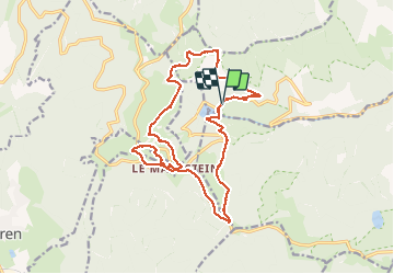
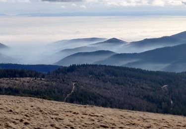
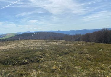
Ruta Senderismo de 17,2 km a descubrir en Gran Este, Alto Rin, Linthal. Esta ruta ha sido propuesta por Richard68500.
Descripción
Belle balade sous le soleil, après une succulente escalope viennoise et une bonne bouteille de riesling offert par notre ami Francis pour ses 82 ans au restaurant Le Tremplin au Markstein mais malheureusement sans dessert...
Localización
País:
France
Región :
Gran Este
Departamento/provincia :
Alto Rin
Municipio :
Linthal
Localidad:
Unknown
Salida:(Dec)
Salida:(UTM)
354127 ; 5311129 (32T) N.
Comentarios
Excursiones cerca
![Excursión Senderismo Linthal - Markstein - Photo](https://media.geolcdn.com/t/375/260/ext.jpg?maxdim=2&url=https%3A%2F%2Fservices.sitytrail.com%2FGeolivesWS%2FDownloadMedia.ashx%3FTrailID%3D266212%26Media%3Dfix__20140413115328.jpg)
![Senderismo Senderismo](https://static1.geolcdn.com/sitytour/trail-icons/101.png)
Markstein
Senderismo
Medio
(3)
Linthal,
Gran Este,
Alto Rin,
France
![](/images/other/stat-length.png)
14 km | 19,8 km-effort
4h 45min
![](https://static1.geolcdn.com/siteimages/upload/files/16400158638029165_repeat_loop_refresh_sync_direction_icon.png)
Sí
![Excursión Senderismo Linthal - Tour de la grande Vallée de Munster (refuge du Hilsen - Munster) - Photo](https://media.geolcdn.com/t/375/260/ext.jpg?maxdim=2&url=https%3A%2F%2Fservices.sitytrail.com%2FGeolivesWS%2FDownloadMedia.ashx%3FTrailID%3D173094%26Media%3D14636_4.jpg)
![Senderismo Senderismo](https://static1.geolcdn.com/sitytour/trail-icons/101.png)
Tour de la grande Vallée de Munster (refuge du Hilsen - Munster)
Senderismo
Difícil
(1)
Linthal,
Gran Este,
Alto Rin,
France
![](/images/other/stat-length.png)
18,1 km | 24 km-effort
5h 0min
![](https://static1.geolcdn.com/siteimages/upload/files/16400158638029165_repeat_loop_refresh_sync_direction_icon.png)
No
![Excursión Senderismo Lautenbachzell - Le Markstein - Photo](https://media.geolcdn.com/t/375/260/ext.jpg?maxdim=2&url=https%3A%2F%2Fservices.sitytrail.com%2FGeolivesWS%2FDownloadMedia.ashx%3FTrailID%3D109647%26Media%3D4288_1.jpg)
![Senderismo Senderismo](https://static1.geolcdn.com/sitytour/trail-icons/101.png)
Le Markstein
Senderismo
Difícil
(1)
Lautenbachzell,
Gran Este,
Alto Rin,
France
![](/images/other/stat-length.png)
22 km | 35 km-effort
6h 0min
![](https://static1.geolcdn.com/siteimages/upload/files/16400158638029165_repeat_loop_refresh_sync_direction_icon.png)
Sí
![Excursión Senderismo Linthal - SityTrail - Remspach-Hilsen - Photo](https://media.geolcdn.com/t/375/260/ext.jpg?maxdim=2&url=https%3A%2F%2Fstatic1.geolcdn.com%2Fsiteimages%2Fupload%2Ffiles%2F1553511878bg_sport_marche.png)
![Senderismo Senderismo](https://static1.geolcdn.com/sitytour/trail-icons/101.png)
SityTrail - Remspach-Hilsen
Senderismo
Medio
(1)
Linthal,
Gran Este,
Alto Rin,
France
![](/images/other/stat-length.png)
9,9 km | 14,6 km-effort
3h 3min
![](https://static1.geolcdn.com/siteimages/upload/files/16400158638029165_repeat_loop_refresh_sync_direction_icon.png)
Sí
![Excursión A pie Lautenbachzell - Parking Bellevue - Hundsrucken - Markstein - Photo](https://media.geolcdn.com/t/375/260/ext.jpg?maxdim=2&url=https%3A%2F%2Fstatic1.geolcdn.com%2Fsiteimages%2Fupload%2Ffiles%2F1545311037marcheuse_200dpi.jpg)
![A pie A pie](https://static1.geolcdn.com/sitytour/trail-icons/100.png)
Parking Bellevue - Hundsrucken - Markstein
A pie
Medio
(1)
Lautenbachzell,
Gran Este,
Alto Rin,
France
![](/images/other/stat-length.png)
9,4 km | 13 km-effort
Desconocido
![](https://static1.geolcdn.com/siteimages/upload/files/16400158638029165_repeat_loop_refresh_sync_direction_icon.png)
Sí
![Excursión Senderismo Sondernach - 2020-01-02 Marche Landersen Petit Ballon - Photo](https://media.geolcdn.com/t/375/260/abff8abb-ba88-42b9-b3e3-f376b36342fa.jpg&format=jpg&maxdim=2)
![Senderismo Senderismo](https://static1.geolcdn.com/sitytour/trail-icons/101.png)
2020-01-02 Marche Landersen Petit Ballon
Senderismo
Difícil
Sondernach,
Gran Este,
Alto Rin,
France
![](/images/other/stat-length.png)
17,6 km | 28 km-effort
3h 4min
![](https://static1.geolcdn.com/siteimages/upload/files/16400158638029165_repeat_loop_refresh_sync_direction_icon.png)
Sí
![Excursión Bici de montaña Metzeral - Breitfirst - Petit Ballon - Col de Firstplan - Wintzenheim - Photo](https://media.geolcdn.com/t/375/260/ext.jpg?maxdim=2&url=https%3A%2F%2Fstatic1.geolcdn.com%2Fsiteimages%2Fupload%2Ffiles%2F1524743154velo.jpg)
![Bici de montaña Bici de montaña](https://static1.geolcdn.com/sitytour/trail-icons/202.png)
Breitfirst - Petit Ballon - Col de Firstplan - Wintzenheim
Bici de montaña
Medio
(1)
Metzeral,
Gran Este,
Alto Rin,
France
![](/images/other/stat-length.png)
38 km | 52 km-effort
3h 11min
![](https://static1.geolcdn.com/siteimages/upload/files/16400158638029165_repeat_loop_refresh_sync_direction_icon.png)
No
![Excursión Senderismo Metzeral - 24 04 14 autour d’Uffrain - Photo](https://media.geolcdn.com/t/375/260/5d272a7d-046b-44ac-82c1-096c8c22e6f1.jpg&format=jpg&maxdim=2)
![Senderismo Senderismo](https://static1.geolcdn.com/sitytour/trail-icons/101.png)
24 04 14 autour d’Uffrain
Senderismo
Metzeral,
Gran Este,
Alto Rin,
France
![](/images/other/stat-length.png)
70 km | 83 km-effort
3h 45min
![](https://static1.geolcdn.com/siteimages/upload/files/16400158638029165_repeat_loop_refresh_sync_direction_icon.png)
No
![Senderismo Senderismo](https://static1.geolcdn.com/sitytour/trail-icons/101.png)
Mon tour des Vosges (4 jours)
Senderismo
Muy difícil
Soultz-Haut-Rhin,
Gran Este,
Alto Rin,
France
![](/images/other/stat-length.png)
71 km | 113 km-effort
25h 38min
![](https://static1.geolcdn.com/siteimages/upload/files/16400158638029165_repeat_loop_refresh_sync_direction_icon.png)
Sí