![](/images/other/stat-length.png)
![Excursión Senderismo Courgeon - Voie Verte Courgeon 7,5 Km - Photo](https://media.geolcdn.com/t/1900/400/ext.pjpeg?maxdim=2&url=https%3A%2F%2Fstatic1.geolcdn.com%2Fsiteimages%2Fupload%2Ffiles%2F1553511878bg_sport_marche.png)
Voie Verte Courgeon 7,5 Km
ODDAD78
Usuario
![Longitud](/images/other/stat-length.png)
![Altitud máxima](https://static1.geolcdn.com/siteimages/upload/files/1508320355ic_sort_altitude_max_24dp.png)
![Desnivel positivo](https://static1.geolcdn.com/siteimages/upload/files/1508320355ic_sort_den_pos_24dp.png)
![Km-Effort](/images/other/stat-length.png)
![Altitud mínima](https://static1.geolcdn.com/siteimages/upload/files/1508320355ic_sort_altitude_min_24dp.png)
![Desnivel negativo](https://static1.geolcdn.com/siteimages/upload/files/1508320355ic_sort_den_neg_24dp.png)
![Boucle](https://static1.geolcdn.com/siteimages/upload/files/16400158638029165_repeat_loop_refresh_sync_direction_icon.png)
![Senderismo](https://static1.geolcdn.com/sitytour/trail-icons/101.png)
1h50
Dificultad : Fácil
![Escanee este código QR para abrir la excursión en la aplicación SityTrail](https://capi.geolives.com/qq0zvz2zws4bq2lad0pu/sitytour/trails/668902/qr.png?size=200)
Aplicación GPS de excursión GRATIS
A propósito
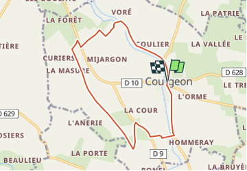
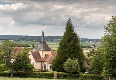
Ruta Senderismo de 7,5 km a descubrir en Normandía, Orne, Courgeon. Esta ruta ha sido propuesta por ODDAD78.
Descripción
Les Boucles de la Voie Verte :
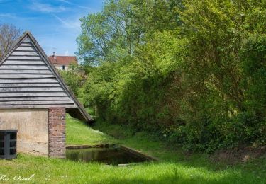
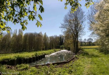
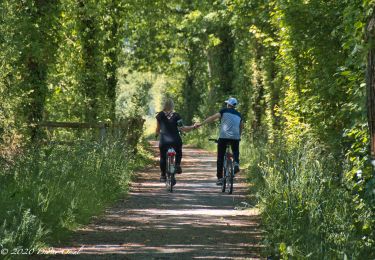
La voir Verte est une ancienne ligne de chemin de fer de 80Km (de Alençon à Condé-sur Huisne) réhabilitée en voie piétonne et cycliste. Je vous propose (en cours de construction) une série de petites randonnées en boucle qui comprenne un aller sur la (monotone ?) voie verte et un retour au point de départ par un autre chemin au coeur du Perche. La présente randonnée part dE l'église de Courgeon et y revient. Bonne Rando sur les chemins du Perche ornais. ODDAD78
Localización
Comentarios
Excursiones cerca
![Excursión Senderismo La Chapelle-Montligeon - [Itinéraire] Le Mont Ligeon - Photo](https://media.geolcdn.com/t/375/260/ce92da88-fb92-411f-965d-5e4e270d0f79.jpeg&format=jpg&maxdim=2)
![Senderismo Senderismo](https://static1.geolcdn.com/sitytour/trail-icons/101.png)
Senderismo
![](/images/other/stat-length.png)
![](https://static1.geolcdn.com/siteimages/upload/files/16400158638029165_repeat_loop_refresh_sync_direction_icon.png)
![Excursión Senderismo Mortagne-au-Perche - SityTrail - La Chapelle-Montligeon - Mortagne-au-Perche 14 km - Photo](https://media.geolcdn.com/t/375/260/ff6e4fe8-c15c-4360-a70d-10a6e0124b39.jpg&format=jpg&maxdim=2)
![Senderismo Senderismo](https://static1.geolcdn.com/sitytour/trail-icons/101.png)
Senderismo
![](/images/other/stat-length.png)
![](https://static1.geolcdn.com/siteimages/upload/files/16400158638029165_repeat_loop_refresh_sync_direction_icon.png)
![Excursión Senderismo La Chapelle-Montligeon - La Chapelle-Montligeon - Longny-au-Perche via Bizou 16 km - Photo](https://media.geolcdn.com/t/375/260/5e36f740-ecc7-4760-b425-4f15cc356d54.jpg&format=jpg&maxdim=2)
![Senderismo Senderismo](https://static1.geolcdn.com/sitytour/trail-icons/101.png)
Senderismo
![](/images/other/stat-length.png)
![](https://static1.geolcdn.com/siteimages/upload/files/16400158638029165_repeat_loop_refresh_sync_direction_icon.png)
![Excursión Senderismo La Chapelle-Montligeon - La Chapelle-Montligeon - Moutiers-au-Perche via Bizou 20 km - Photo](https://media.geolcdn.com/t/375/260/4094c967-a97a-44d3-924e-010e9be9049f.jpg&format=jpg&maxdim=2)
![Senderismo Senderismo](https://static1.geolcdn.com/sitytour/trail-icons/101.png)
Senderismo
![](/images/other/stat-length.png)
![](https://static1.geolcdn.com/siteimages/upload/files/16400158638029165_repeat_loop_refresh_sync_direction_icon.png)
![Excursión Senderismo La Chapelle-Montligeon - La Chapelle-Montligeon - Le Mage via Bizou 18 km - Photo](https://media.geolcdn.com/t/375/260/2514d07f-ce42-4914-ba12-eb561f06fea2.jpg&format=jpg&maxdim=2)
![Senderismo Senderismo](https://static1.geolcdn.com/sitytour/trail-icons/101.png)
Senderismo
![](/images/other/stat-length.png)
![](https://static1.geolcdn.com/siteimages/upload/files/16400158638029165_repeat_loop_refresh_sync_direction_icon.png)
![Excursión Senderismo Mauves-sur-Huisne - Mauves-sur-Huisne - Nocé-Courboyer 14 km - Photo](https://media.geolcdn.com/t/375/260/466f9b4c-93ba-4aca-9d1e-6d5326965a9d.jpg&format=jpg&maxdim=2)
![Senderismo Senderismo](https://static1.geolcdn.com/sitytour/trail-icons/101.png)
Senderismo
![](/images/other/stat-length.png)
![](https://static1.geolcdn.com/siteimages/upload/files/16400158638029165_repeat_loop_refresh_sync_direction_icon.png)
![Excursión Senderismo La Chapelle-Montligeon - La Chapelle-Montligeon - Mauves-sur-Huisne 7,8 km - Photo](https://media.geolcdn.com/t/375/260/fe531396-d696-4b85-843a-3574d25662eb.jpg&format=jpg&maxdim=2)
![Senderismo Senderismo](https://static1.geolcdn.com/sitytour/trail-icons/101.png)
Senderismo
![](/images/other/stat-length.png)
![](https://static1.geolcdn.com/siteimages/upload/files/16400158638029165_repeat_loop_refresh_sync_direction_icon.png)
![Excursión Senderismo Mauves-sur-Huisne - Mauves-sur-Huisne - Mortagne-au-Perche 11 km - Photo](https://media.geolcdn.com/t/375/260/2520701b-de52-4bea-9db4-ad9767ef6f28.jpg&format=jpg&maxdim=2)
![Senderismo Senderismo](https://static1.geolcdn.com/sitytour/trail-icons/101.png)
Senderismo
![](/images/other/stat-length.png)
![](https://static1.geolcdn.com/siteimages/upload/files/16400158638029165_repeat_loop_refresh_sync_direction_icon.png)
![Excursión Senderismo La Chapelle-Montligeon - La Chapelle-Montligeon - Tourouvre 19 km - Photo](https://media.geolcdn.com/t/375/260/a31c6835-bfa1-4431-b7fc-3b6c5f1acc90.jpg&format=jpg&maxdim=2)
![Senderismo Senderismo](https://static1.geolcdn.com/sitytour/trail-icons/101.png)
Senderismo
![](/images/other/stat-length.png)
![](https://static1.geolcdn.com/siteimages/upload/files/16400158638029165_repeat_loop_refresh_sync_direction_icon.png)