![](/images/other/stat-length.png)
![Excursión Senderismo Cour-Maugis sur Huisne - La Maison de Maugis 8,2 Km - Photo](https://media.geolcdn.com/t/1900/400/1c29e1c7-2119-4c54-a833-18fd45a7ef35.jpg&format=pjpeg&maxdim=2)
La Maison de Maugis 8,2 Km
ODDAD78
Usuario
![Longitud](/images/other/stat-length.png)
![Altitud máxima](https://static1.geolcdn.com/siteimages/upload/files/1508320355ic_sort_altitude_max_24dp.png)
![Desnivel positivo](https://static1.geolcdn.com/siteimages/upload/files/1508320355ic_sort_den_pos_24dp.png)
![Km-Effort](/images/other/stat-length.png)
![Altitud mínima](https://static1.geolcdn.com/siteimages/upload/files/1508320355ic_sort_altitude_min_24dp.png)
![Desnivel negativo](https://static1.geolcdn.com/siteimages/upload/files/1508320355ic_sort_den_neg_24dp.png)
![Boucle](https://static1.geolcdn.com/siteimages/upload/files/16400158638029165_repeat_loop_refresh_sync_direction_icon.png)
![Senderismo](https://static1.geolcdn.com/sitytour/trail-icons/101.png)
2h13
Dificultad : Fácil
![Escanee este código QR para abrir la excursión en la aplicación SityTrail](https://capi.geolives.com/qq0zvz2zws4bq2lad0pu/sitytour/trails/660435/qr.png?size=200)
Aplicación GPS de excursión GRATIS
A propósito
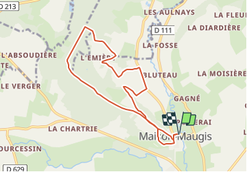
Ruta Senderismo de 8,2 km a descubrir en Normandía, Orne, Cour-Maugis sur Huisne. Esta ruta ha sido propuesta por ODDAD78.
Descripción
Circuit balisé en jaune signalétique (suivre les flèches "La Maison de Maugis")
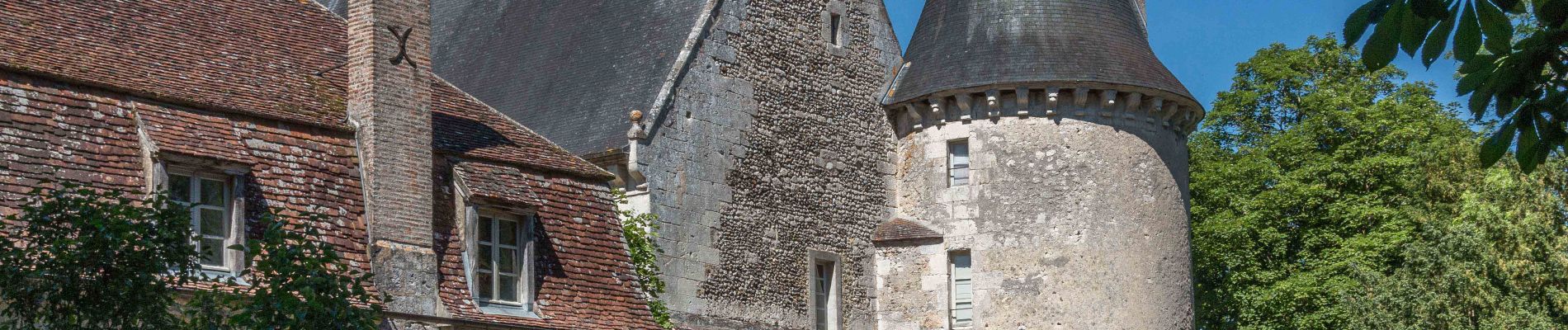
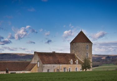
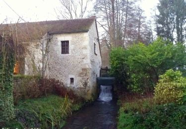
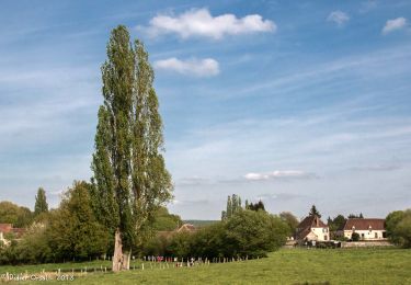
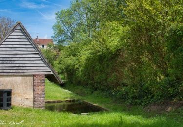
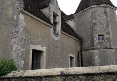
Le circuit démarre sur le parking (tables de pique-nique à proximité), près du pont sur la rivière La Commeauche. A la sortie du parking, prendre à droite pour traverser le village. Dans un renfoncement, après la Mairie, se trouve le monument aux morts et une stèle commémorative de victimes de la Seconde guerre mondiale. Il est possible de prendre la 1ère rue à gauche en suivant le bief pour aller jusqu’au moulin et ensuite revenir sur ses pas et poursuivre la traversée du village par la gauche. Dépasser le château et l’église Saint-Nicolas pour aller admirer l’allée de Marronniers.
Revenir sur ses pas et, après le jardin potager du château, prendre à gauche le chemin goudronné « La Galaisière» qui monte le long du jardin. C’est le GR 22, balisé Rouge et Blanc, que l’on suit en empruntant, à la fin du goudronnage, un chemin à droite. Après environ 100m le chemin continue, à gauche, en traversant les bois de la Tuilerie avant d’entrer dans la forêt domaniale de Réno-Valdieu.
Au grand carrefour il faut prendre le grand chemin forestier à droite que l’on suit sur 700 m. On quitte alors le GR22 pour emprunter le premier sentier à droite en traversant le fossé. Le chemin descend en serpentant dans le bois sur environ 300 m. Puis continuer à gauche par le chemin rural qui longe les bois sur environ 500 m jusqu’à une petite route goudronnée.
Il faut alors tourner à droite dans le chemin que l’on suit sur 300 m avant de tourner complètement à gauche. Suivre ce chemin sur 400 m puis tourner encore à gauche. Le chemin bientôt goudronné descend vers la Piquenotière en laissant à gauche la Hutinière et arrive à la route D 291.
Localización
Comentarios
Excursiones cerca
![Excursión Senderismo Longny les Villages - Monceaux au Perche (Boucle) - Photo](https://media.geolcdn.com/t/375/260/ext.jpg?maxdim=2&url=https%3A%2F%2Fstatic1.geolcdn.com%2Fsiteimages%2Fupload%2Ffiles%2F1553511878bg_sport_marche.png)
![Senderismo Senderismo](https://static1.geolcdn.com/sitytour/trail-icons/101.png)
Senderismo
![](/images/other/stat-length.png)
![](https://static1.geolcdn.com/siteimages/upload/files/16400158638029165_repeat_loop_refresh_sync_direction_icon.png)
![Excursión Senderismo Bizou - [Itinéraire] Les sables du Perche - Photo](https://media.geolcdn.com/t/375/260/6b586e88-fad3-40df-be07-9b2a61186b9b.jpeg&format=jpg&maxdim=2)
![Senderismo Senderismo](https://static1.geolcdn.com/sitytour/trail-icons/101.png)
Senderismo
![](/images/other/stat-length.png)
![](https://static1.geolcdn.com/siteimages/upload/files/16400158638029165_repeat_loop_refresh_sync_direction_icon.png)
![Excursión Senderismo Rémalard en Perche - 2023-05-11_20h45m08_Randos 61 2023 3 Sur les terres du siège de Rémalard 9,5 km - Photo](https://media.geolcdn.com/t/375/260/4c079e8c-69f5-4bc5-9fc4-11ac01016a7e.jpg&format=jpg&maxdim=2)
![Senderismo Senderismo](https://static1.geolcdn.com/sitytour/trail-icons/101.png)
Senderismo
![](/images/other/stat-length.png)
![](https://static1.geolcdn.com/siteimages/upload/files/16400158638029165_repeat_loop_refresh_sync_direction_icon.png)
![Excursión Senderismo La Chapelle-Montligeon - [Itinéraire] Le Mont Ligeon - Photo](https://media.geolcdn.com/t/375/260/ce92da88-fb92-411f-965d-5e4e270d0f79.jpeg&format=jpg&maxdim=2)
![Senderismo Senderismo](https://static1.geolcdn.com/sitytour/trail-icons/101.png)
Senderismo
![](/images/other/stat-length.png)
![](https://static1.geolcdn.com/siteimages/upload/files/16400158638029165_repeat_loop_refresh_sync_direction_icon.png)
![Excursión Senderismo Cour-Maugis sur Huisne - 12102996-Maison Maugis 22.37 - Photo](https://media.geolcdn.com/t/375/260/ext.jpg?maxdim=2&url=https%3A%2F%2Fstatic1.geolcdn.com%2Fsiteimages%2Fupload%2Ffiles%2F1553511878bg_sport_marche.png)
![Senderismo Senderismo](https://static1.geolcdn.com/sitytour/trail-icons/101.png)
Senderismo
![](/images/other/stat-length.png)
![](https://static1.geolcdn.com/siteimages/upload/files/16400158638029165_repeat_loop_refresh_sync_direction_icon.png)
![Excursión Senderismo La Chapelle-Montligeon - La Chapelle-Montligeon - Longny-au-Perche via Bizou 16 km - Photo](https://media.geolcdn.com/t/375/260/5e36f740-ecc7-4760-b425-4f15cc356d54.jpg&format=jpg&maxdim=2)
![Senderismo Senderismo](https://static1.geolcdn.com/sitytour/trail-icons/101.png)
Senderismo
![](/images/other/stat-length.png)
![](https://static1.geolcdn.com/siteimages/upload/files/16400158638029165_repeat_loop_refresh_sync_direction_icon.png)
![Excursión Senderismo La Chapelle-Montligeon - La Chapelle-Montligeon - Moutiers-au-Perche via Bizou 20 km - Photo](https://media.geolcdn.com/t/375/260/4094c967-a97a-44d3-924e-010e9be9049f.jpg&format=jpg&maxdim=2)
![Senderismo Senderismo](https://static1.geolcdn.com/sitytour/trail-icons/101.png)
Senderismo
![](/images/other/stat-length.png)
![](https://static1.geolcdn.com/siteimages/upload/files/16400158638029165_repeat_loop_refresh_sync_direction_icon.png)
![Excursión Senderismo La Chapelle-Montligeon - La Chapelle-Montligeon - Le Mage via Bizou 18 km - Photo](https://media.geolcdn.com/t/375/260/2514d07f-ce42-4914-ba12-eb561f06fea2.jpg&format=jpg&maxdim=2)
![Senderismo Senderismo](https://static1.geolcdn.com/sitytour/trail-icons/101.png)
Senderismo
![](/images/other/stat-length.png)
![](https://static1.geolcdn.com/siteimages/upload/files/16400158638029165_repeat_loop_refresh_sync_direction_icon.png)
![Excursión Senderismo Longny les Villages - Monceaux et le Manoir - Photo](https://media.geolcdn.com/t/375/260/2c895f3a-5924-449a-a873-4ad274746411.jpg&format=jpg&maxdim=2)
![Senderismo Senderismo](https://static1.geolcdn.com/sitytour/trail-icons/101.png)
Senderismo
![](/images/other/stat-length.png)
![](https://static1.geolcdn.com/siteimages/upload/files/16400158638029165_repeat_loop_refresh_sync_direction_icon.png)