![](/images/other/stat-length.png)
![Excursión Senderismo Moutiers-au-Perche - Le Gué de Culoiseau 6,6 Km - Photo](https://media.geolcdn.com/t/1900/400/11c29527-0608-4647-a14c-fa9517a3088e.jpg&format=pjpeg&maxdim=2)
Le Gué de Culoiseau 6,6 Km
ODDAD78
Usuario
![Longitud](/images/other/stat-length.png)
![Altitud máxima](https://static1.geolcdn.com/siteimages/upload/files/1508320355ic_sort_altitude_max_24dp.png)
![Desnivel positivo](https://static1.geolcdn.com/siteimages/upload/files/1508320355ic_sort_den_pos_24dp.png)
![Km-Effort](/images/other/stat-length.png)
![Altitud mínima](https://static1.geolcdn.com/siteimages/upload/files/1508320355ic_sort_altitude_min_24dp.png)
![Desnivel negativo](https://static1.geolcdn.com/siteimages/upload/files/1508320355ic_sort_den_neg_24dp.png)
![Boucle](https://static1.geolcdn.com/siteimages/upload/files/16400158638029165_repeat_loop_refresh_sync_direction_icon.png)
![Senderismo](https://static1.geolcdn.com/sitytour/trail-icons/101.png)
1h57
Dificultad : Muy fácil
![Escanee este código QR para abrir la excursión en la aplicación SityTrail](https://capi.geolives.com/qq0zvz2zws4bq2lad0pu/sitytour/trails/660219/qr.png?size=200)
Aplicación GPS de excursión GRATIS
A propósito
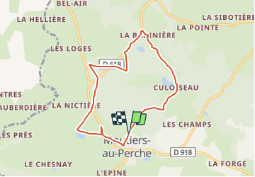
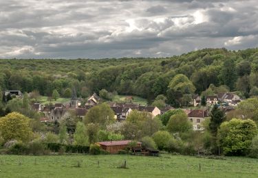
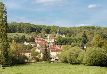
Ruta Senderismo de 6,9 km a descubrir en Normandía, Orne, Moutiers-au-Perche. Esta ruta ha sido propuesta por ODDAD78.
Descripción
Pas à Pas :
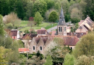
Au départ de l’église, monter le chemin empierré en direction du bois. A gauche, château d'eau semi-enterré. Pénétrer en sous-bois.
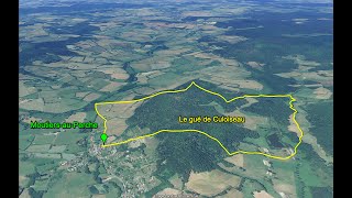
Au carrefour en fourche signalé par une croix, prendre à droite. Photo1 Couper une large allée transversale et descendre pour déboucher à Culoiseau..
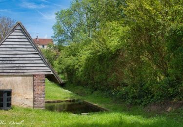
Franchir le ruisseau de la Feuillée sur une passerelle. Le chemin dit du "Champ Pierru", bien délimité par les clôtures, serpente entre les herbages. Après un parcours sinueux, déboucher au hameau de la Badinière. Le Traverser.
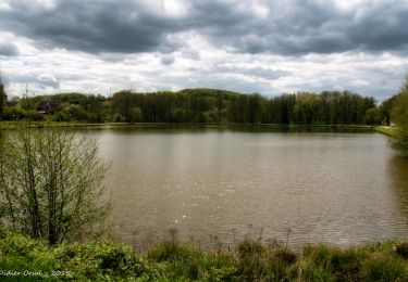
A gauche, emprunter la D 618. Passer le pont qui enjambe la Feuillée. Laisser à droite, le chemin de la Baillère et continuer la route sur 200M. A hauteur d'un étang (à droite), prendre à gauche, un chemin en sous-bois.
Au croisement, tourner à droite. Traverser la D 618 et prendre en face
A l'intersection en "X", bifurquer à gauche en angle aigu. Couper de nouveau la D 618 et prendre en face le chemin de droite. Rejoindre la D 918 près d'une croix. Traverser la départementale avec prudence. En face, descendre le chemin herbeux aboutissant au pont Poirier, sur la Corbionne.
Tourner à gauche. Passer devant la Tortière. Le petit Chesnay. Traverser de nouveau la D 918. Prendre en face le chemin de terre.
Retour au point de départ par la rue de la Suiferie et à gauche, en montant la rue de l'église (rampe forte)
Localización
Comentarios
Excursiones cerca
![Excursión Senderismo La Madeleine-Bouvet - Les belles vues de Saint-Laumer et de la Madeleine Variante 10 Km - Photo](https://media.geolcdn.com/t/375/260/87362449-0ee3-40df-8df0-c17fd7220994.jpg&format=jpg&maxdim=2)
![Senderismo Senderismo](https://static1.geolcdn.com/sitytour/trail-icons/101.png)
Senderismo
![](/images/other/stat-length.png)
![](https://static1.geolcdn.com/siteimages/upload/files/16400158638029165_repeat_loop_refresh_sync_direction_icon.png)
![Excursión Senderismo La Madeleine-Bouvet - Les belles vues de Saint-Laumer et de la Madeleine 11 Km - Photo](https://media.geolcdn.com/t/375/260/3ee85883-b7ae-45a3-90c4-8bb6a4479600.jpg&format=jpg&maxdim=2)
![Senderismo Senderismo](https://static1.geolcdn.com/sitytour/trail-icons/101.png)
Senderismo
![](/images/other/stat-length.png)
![](https://static1.geolcdn.com/siteimages/upload/files/16400158638029165_repeat_loop_refresh_sync_direction_icon.png)
![Excursión Senderismo Moutiers-au-Perche - 2023-05-20_10h18m41_Moutiers-au-Perche Rando de Samedi - Photo](https://media.geolcdn.com/t/375/260/dd304cf5-1fa7-4625-9960-289d50411375.jpg&format=jpg&maxdim=2)
![Senderismo Senderismo](https://static1.geolcdn.com/sitytour/trail-icons/101.png)
Senderismo
![](/images/other/stat-length.png)
![](https://static1.geolcdn.com/siteimages/upload/files/16400158638029165_repeat_loop_refresh_sync_direction_icon.png)
![Excursión A pie Moutiers-au-Perche - Perche authentique - Photo](https://media.geolcdn.com/t/375/260/1c5fa599-8a3f-4902-99d5-149fc7bd1ba4.jpeg&format=jpg&maxdim=2)
![A pie A pie](https://static1.geolcdn.com/sitytour/trail-icons/100.png)
A pie
![](/images/other/stat-length.png)
![](https://static1.geolcdn.com/siteimages/upload/files/16400158638029165_repeat_loop_refresh_sync_direction_icon.png)
![Excursión Senderismo Le Mage - Le Mage - Longny-au-Perche (Longny les Villages) 11 km - Photo](https://media.geolcdn.com/t/375/260/7da85c06-6bc5-432c-afb8-5444ae0d01ad.jpg&format=jpg&maxdim=2)
![Senderismo Senderismo](https://static1.geolcdn.com/sitytour/trail-icons/101.png)
Senderismo
![](/images/other/stat-length.png)
![](https://static1.geolcdn.com/siteimages/upload/files/16400158638029165_repeat_loop_refresh_sync_direction_icon.png)
![Excursión Senderismo Le Mage - Le Mage - Moutiers-au-Perche 9,2 km - Photo](https://media.geolcdn.com/t/375/260/2d6a74b1-d9ee-4f0d-9acb-9c00ceb2d8ab.jpg&format=jpg&maxdim=2)
![Senderismo Senderismo](https://static1.geolcdn.com/sitytour/trail-icons/101.png)
Senderismo
![](/images/other/stat-length.png)
![](https://static1.geolcdn.com/siteimages/upload/files/16400158638029165_repeat_loop_refresh_sync_direction_icon.png)
![Excursión Senderismo La Madeleine-Bouvet - Bretoncelles - La Madeleine-Bouvet 5,3 km - Photo](https://media.geolcdn.com/t/375/260/573e294c-51f9-41fe-8907-e8f30e9f4bad.jpg&format=jpg&maxdim=2)
![Senderismo Senderismo](https://static1.geolcdn.com/sitytour/trail-icons/101.png)
Senderismo
![](/images/other/stat-length.png)
![](https://static1.geolcdn.com/siteimages/upload/files/16400158638029165_repeat_loop_refresh_sync_direction_icon.png)
![Excursión Senderismo Bretoncelles - SityTrail - Les Douves du Grand Cumont Bretoncelles V2 15 Km - Photo](https://media.geolcdn.com/t/375/260/d3f7aac7-ac8c-46dc-96d3-852253cb1421.jpg&format=jpg&maxdim=2)
![Senderismo Senderismo](https://static1.geolcdn.com/sitytour/trail-icons/101.png)
Senderismo
![](/images/other/stat-length.png)
![](https://static1.geolcdn.com/siteimages/upload/files/16400158638029165_repeat_loop_refresh_sync_direction_icon.png)
![Excursión Senderismo Bretoncelles - SityTrail - Le Petit Houx du Parc - Bretoncelles 5,1 Km - Photo](https://media.geolcdn.com/t/375/260/7bdb7e04-5754-4fe7-8144-30a332f42ad5.jpg&format=jpg&maxdim=2)
![Senderismo Senderismo](https://static1.geolcdn.com/sitytour/trail-icons/101.png)
Senderismo
![](/images/other/stat-length.png)
![](https://static1.geolcdn.com/siteimages/upload/files/16400158638029165_repeat_loop_refresh_sync_direction_icon.png)