![](/images/other/stat-length.png)
![Excursión Senderismo Saint-Félix-de-Sorgues - Aveyron - St-Felix-de-Sorgues circuit des Hospitaliers 17km 514m - Photo](https://media.geolcdn.com/t/1900/400/ext.pjpeg?maxdim=2&url=https%3A%2F%2Fstatic1.geolcdn.com%2Fsiteimages%2Fupload%2Ffiles%2F1553511878bg_sport_marche.png)
Aveyron - St-Felix-de-Sorgues circuit des Hospitaliers 17km 514m
RandoVal
Usuario
![Longitud](/images/other/stat-length.png)
Longitud
17 km
![Altitud máxima](https://static1.geolcdn.com/siteimages/upload/files/1508320355ic_sort_altitude_max_24dp.png)
Altitud máxima
750 m
![Desnivel positivo](https://static1.geolcdn.com/siteimages/upload/files/1508320355ic_sort_den_pos_24dp.png)
Desnivel positivo
568 m
![Km-Effort](/images/other/stat-length.png)
Km-Effort
25 km
![Altitud mínima](https://static1.geolcdn.com/siteimages/upload/files/1508320355ic_sort_altitude_min_24dp.png)
Altitud mínima
370 m
![Desnivel negativo](https://static1.geolcdn.com/siteimages/upload/files/1508320355ic_sort_den_neg_24dp.png)
Desnivel negativo
567 m
![Boucle](https://static1.geolcdn.com/siteimages/upload/files/16400158638029165_repeat_loop_refresh_sync_direction_icon.png)
Boucle
Sí
Fecha de creación :
2018-09-12 19:08:58.986
Última modificación :
2018-09-12 19:08:58.996
![Senderismo](https://static1.geolcdn.com/sitytour/trail-icons/101.png)
5h09
Dificultad : Medio
![Escanee este código QR para abrir la excursión en la aplicación SityTrail](https://capi.geolives.com/qq0zvz2zws4bq2lad0pu/sitytour/trails/654698/qr.png?size=200)
Aplicación GPS de excursión GRATIS
A propósito
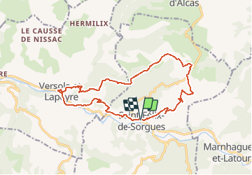
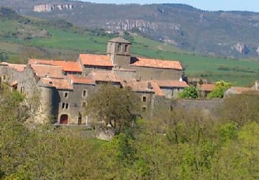
Ruta Senderismo de 17 km a descubrir en Occitania, Aveyron, Saint-Félix-de-Sorgues. Esta ruta ha sido propuesta por RandoVal.
Descripción
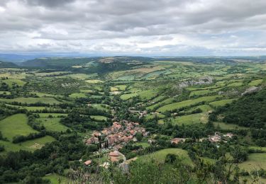
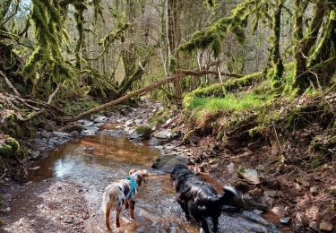
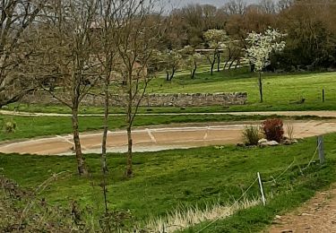
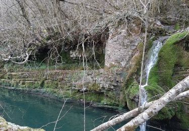
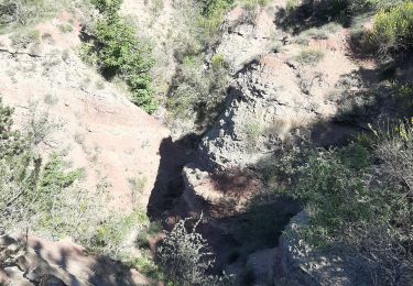
Rando en Aveyron autour du village de Saint-Félix-de-Sorgues . Départ du parking co-voiturage, sens anti-horaire.
Version moyenne
Localización
País:
France
Región :
Occitania
Departamento/provincia :
Aveyron
Municipio :
Saint-Félix-de-Sorgues
Localidad:
Unknown
Salida:(Dec)
Salida:(UTM)
498705 ; 4859025 (31T) N.
Comentarios
Excursiones cerca
![Excursión Senderismo Saint-Jean-et-Saint-Paul - St jean d alcas cornus - Photo](https://media.geolcdn.com/t/375/260/965f3835-4431-4ee8-830b-677a7e547d2c.jpg&format=jpg&maxdim=2)
![Senderismo Senderismo](https://static1.geolcdn.com/sitytour/trail-icons/101.png)
St jean d alcas cornus
Senderismo
Difícil
Saint-Jean-et-Saint-Paul,
Occitania,
Aveyron,
France
![](/images/other/stat-length.png)
21 km | 27 km-effort
7h 13min
![](https://static1.geolcdn.com/siteimages/upload/files/16400158638029165_repeat_loop_refresh_sync_direction_icon.png)
No
![Excursión Senderismo Montagnol - Le mazet trounas montagneol le mazet - Photo](https://media.geolcdn.com/t/375/260/b5223991-6d3e-4410-9cc4-400ff41c52c5.jpg&format=jpg&maxdim=2)
![Senderismo Senderismo](https://static1.geolcdn.com/sitytour/trail-icons/101.png)
Le mazet trounas montagneol le mazet
Senderismo
Medio
Montagnol,
Occitania,
Aveyron,
France
![](/images/other/stat-length.png)
8,2 km | 11,3 km-effort
2h 0min
![](https://static1.geolcdn.com/siteimages/upload/files/16400158638029165_repeat_loop_refresh_sync_direction_icon.png)
Sí
![Excursión Carrera Marnhagues-et-Latour - nonenque vialaret batisse nonenque - Photo](https://media.geolcdn.com/t/375/260/8d470d0a-becf-42ec-944e-496f75cba1bf.jpg&format=jpg&maxdim=2)
![Carrera Carrera](https://static1.geolcdn.com/sitytour/trail-icons/103.png)
nonenque vialaret batisse nonenque
Carrera
Muy fácil
Marnhagues-et-Latour,
Occitania,
Aveyron,
France
![](/images/other/stat-length.png)
10,3 km | 14,6 km-effort
2h 4min
![](https://static1.geolcdn.com/siteimages/upload/files/16400158638029165_repeat_loop_refresh_sync_direction_icon.png)
Sí
![Excursión Senderismo Marnhagues-et-Latour - nonenque vierges grotte nonenque - Photo](https://media.geolcdn.com/t/375/260/3462e9a6-84a0-4a73-b499-c614a171b68e.jpg&format=jpg&maxdim=2)
![Senderismo Senderismo](https://static1.geolcdn.com/sitytour/trail-icons/101.png)
nonenque vierges grotte nonenque
Senderismo
Muy fácil
Marnhagues-et-Latour,
Occitania,
Aveyron,
France
![](/images/other/stat-length.png)
4,5 km | 7,2 km-effort
1h 33min
![](https://static1.geolcdn.com/siteimages/upload/files/16400158638029165_repeat_loop_refresh_sync_direction_icon.png)
Sí
![Excursión Carrera Marnhagues-et-Latour - roquaubel brûle par marquisard - Photo](https://media.geolcdn.com/t/375/260/ee95a00b-8dd9-4005-b106-d277f91d9eaa.jpg&format=jpg&maxdim=2)
![Carrera Carrera](https://static1.geolcdn.com/sitytour/trail-icons/103.png)
roquaubel brûle par marquisard
Carrera
Muy fácil
Marnhagues-et-Latour,
Occitania,
Aveyron,
France
![](/images/other/stat-length.png)
7,3 km | 10,7 km-effort
1h 27min
![](https://static1.geolcdn.com/siteimages/upload/files/16400158638029165_repeat_loop_refresh_sync_direction_icon.png)
Sí
![Excursión Senderismo Saint-Jean-et-Saint-Paul - St Jean alcas - Photo](https://media.geolcdn.com/t/375/260/ext.jpg?maxdim=2&url=https%3A%2F%2Fservices.sitytrail.com%2FGeolivesWS%2FDownloadMedia.ashx%3FTrailID%3D273794%26Media%3Dfix__20140504155729.jpg)
![Senderismo Senderismo](https://static1.geolcdn.com/sitytour/trail-icons/101.png)
St Jean alcas
Senderismo
Fácil
Saint-Jean-et-Saint-Paul,
Occitania,
Aveyron,
France
![](/images/other/stat-length.png)
18 km | 23 km-effort
6h 58min
![](https://static1.geolcdn.com/siteimages/upload/files/16400158638029165_repeat_loop_refresh_sync_direction_icon.png)
No
![Excursión Senderismo Versols-et-Lapeyre - Versols 2024- 11 10 - Photo](https://media.geolcdn.com/t/375/260/ext.jpg?maxdim=2&url=https%3A%2F%2Fstatic1.geolcdn.com%2Fsiteimages%2Fupload%2Ffiles%2F1553511878bg_sport_marche.png)
![Senderismo Senderismo](https://static1.geolcdn.com/sitytour/trail-icons/101.png)
Versols 2024- 11 10
Senderismo
Muy difícil
Versols-et-Lapeyre,
Occitania,
Aveyron,
France
![](/images/other/stat-length.png)
22 km | 31 km-effort
7h 5min
![](https://static1.geolcdn.com/siteimages/upload/files/16400158638029165_repeat_loop_refresh_sync_direction_icon.png)
Sí
![Excursión Senderismo Gissac - les Canyons du Rougier - Photo](https://media.geolcdn.com/t/375/260/ext.jpg?maxdim=2&url=https%3A%2F%2Fstatic1.geolcdn.com%2Fsiteimages%2Fupload%2Ffiles%2F1553511878bg_sport_marche.png)
![Senderismo Senderismo](https://static1.geolcdn.com/sitytour/trail-icons/101.png)
les Canyons du Rougier
Senderismo
Medio
Gissac,
Occitania,
Aveyron,
France
![](/images/other/stat-length.png)
9,7 km | 13,1 km-effort
2h 45min
![](https://static1.geolcdn.com/siteimages/upload/files/16400158638029165_repeat_loop_refresh_sync_direction_icon.png)
Sí
![Excursión Senderismo Saint-Félix-de-Sorgues - la Loubiere - Photo](https://media.geolcdn.com/t/375/260/8fc58615-67b2-4839-bc32-0d7a1835e308.jpg&format=jpg&maxdim=2)
![Senderismo Senderismo](https://static1.geolcdn.com/sitytour/trail-icons/101.png)
la Loubiere
Senderismo
Medio
Saint-Félix-de-Sorgues,
Occitania,
Aveyron,
France
![](/images/other/stat-length.png)
5,7 km | 7,8 km-effort
2h 5min
![](https://static1.geolcdn.com/siteimages/upload/files/16400158638029165_repeat_loop_refresh_sync_direction_icon.png)
Sí