![](/images/other/stat-length.png)
![Excursión Senderismo Trooz - Transcalestienne Fraipont-Aywaille - Photo](https://media.geolcdn.com/t/1900/400/ext.pjpeg?maxdim=2&url=https%3A%2F%2Fstatic1.geolcdn.com%2Fsiteimages%2Fupload%2Ffiles%2F1553511878bg_sport_marche.png)
Transcalestienne Fraipont-Aywaille
so.duchateau
Usuario
![Longitud](/images/other/stat-length.png)
![Altitud máxima](https://static1.geolcdn.com/siteimages/upload/files/1508320355ic_sort_altitude_max_24dp.png)
![Desnivel positivo](https://static1.geolcdn.com/siteimages/upload/files/1508320355ic_sort_den_pos_24dp.png)
![Km-Effort](/images/other/stat-length.png)
![Altitud mínima](https://static1.geolcdn.com/siteimages/upload/files/1508320355ic_sort_altitude_min_24dp.png)
![Desnivel negativo](https://static1.geolcdn.com/siteimages/upload/files/1508320355ic_sort_den_neg_24dp.png)
![Boucle](https://static1.geolcdn.com/siteimages/upload/files/16400158638029165_repeat_loop_refresh_sync_direction_icon.png)
![Senderismo](https://static1.geolcdn.com/sitytour/trail-icons/101.png)
5h00
Dificultad : Medio
![Escanee este código QR para abrir la excursión en la aplicación SityTrail](https://capi.geolives.com/qq0zvz2zws4bq2lad0pu/sitytour/trails/653704/qr.png?size=200)
Aplicación GPS de excursión GRATIS
A propósito
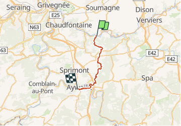
Ruta Senderismo de 21 km a descubrir en Valonia, Lieja, Trooz. Esta ruta ha sido propuesta por so.duchateau.
Descripción
Au cours de cette étape nous aurons l'occasion de découvrir une curiosité de la Calestienne : les chantoirs. Dont sans nul doute le plus spectaculaire : la chantoir de Grandchamps.
Francisation du wallon « tchantwère ». Au moment où le ruisseau s'engouffre dans le sol, le bruit que fait l'eau fit dire aux habitants, sans doute un peu poètes, que celle-ci chantait, d'où le mot chantoire.
Tous les détails de cette étape :
www.cerclepegase.be/sejours/transcalestienne/transcalestienne06.htm
Localización
Comentarios
Excursiones cerca
![Excursión Senderismo Pepinster - RB-Lg-23_Soiron_via-racc-2 - Photo](https://media.geolcdn.com/t/375/260/ext.jpg?maxdim=2&url=https%3A%2F%2Fservices.sitytrail.com%2FGeolivesWS%2FDownloadMedia.ashx%3FTrailID%3D400856%26Media%3D1646b7fd-8650-448d-bc3d-5efa9ed8c932.jpg)
![Senderismo Senderismo](https://static1.geolcdn.com/sitytour/trail-icons/101.png)
Senderismo
![](/images/other/stat-length.png)
![](https://static1.geolcdn.com/siteimages/upload/files/16400158638029165_repeat_loop_refresh_sync_direction_icon.png)
![Excursión Senderismo Pepinster - RB-Lg-23_Soiron - Photo](https://media.geolcdn.com/t/375/260/ext.jpg?maxdim=2&url=https%3A%2F%2Fservices.sitytrail.com%2FGeolivesWS%2FDownloadMedia.ashx%3FTrailID%3D400853%26Media%3D1646b7fd-8650-448d-bc3d-5efa9ed8c932.jpg)
![Senderismo Senderismo](https://static1.geolcdn.com/sitytour/trail-icons/101.png)
![Excursión Senderismo Trooz - RB-Lg-03 - Entre Vesdre et Hoëgne - Photo](https://media.geolcdn.com/t/375/260/ext.jpg?maxdim=2&url=https%3A%2F%2Fservices.sitytrail.com%2FGeolivesWS%2FDownloadMedia.ashx%3FTrailID%3D179559%26Media%3Dcef2de81-7d4f-4fcd-9e9d-f315370fe61f.jpg)
![Senderismo Senderismo](https://static1.geolcdn.com/sitytour/trail-icons/101.png)
Senderismo
![](/images/other/stat-length.png)
![](https://static1.geolcdn.com/siteimages/upload/files/16400158638029165_repeat_loop_refresh_sync_direction_icon.png)
![Excursión Senderismo Sprimont - Banneux - Rouge Thier - Adzeux - Photo](https://media.geolcdn.com/t/375/260/0f185ab2-d29a-4b49-b676-7a8415068951.jpg&format=jpg&maxdim=2)
![Senderismo Senderismo](https://static1.geolcdn.com/sitytour/trail-icons/101.png)
Senderismo
![](/images/other/stat-length.png)
![](https://static1.geolcdn.com/siteimages/upload/files/16400158638029165_repeat_loop_refresh_sync_direction_icon.png)
![Excursión Senderismo Pepinster - 2022-05-13_11h44m22_Cirkwi-Soiron_6___Tribomont,_Wegnez - Photo](https://media.geolcdn.com/t/375/260/ec8c930a-9871-4566-956d-2a2016034199.jpg&format=jpg&maxdim=2)
![Senderismo Senderismo](https://static1.geolcdn.com/sitytour/trail-icons/101.png)
Senderismo
![](/images/other/stat-length.png)
![](https://static1.geolcdn.com/siteimages/upload/files/16400158638029165_repeat_loop_refresh_sync_direction_icon.png)
![Senderismo Senderismo](https://static1.geolcdn.com/sitytour/trail-icons/101.png)
Senderismo
![](/images/other/stat-length.png)
![](https://static1.geolcdn.com/siteimages/upload/files/16400158638029165_repeat_loop_refresh_sync_direction_icon.png)
![Excursión Senderismo Trooz - 2022-02-03_17h57m35_BaladedeFraipont - Photo](https://media.geolcdn.com/t/375/260/a22be754-a7d6-4ac7-b88b-6e30a6735908.jpg&format=jpg&maxdim=2)
![Senderismo Senderismo](https://static1.geolcdn.com/sitytour/trail-icons/101.png)
Senderismo
![](/images/other/stat-length.png)
![](https://static1.geolcdn.com/siteimages/upload/files/16400158638029165_repeat_loop_refresh_sync_direction_icon.png)
![Excursión Senderismo Trooz - 2021-05-16_08h02m48_1403 - Photo](https://media.geolcdn.com/t/375/260/d573d865-936c-49e5-ac73-8dda0a954532.jpg&format=jpg&maxdim=2)
![Senderismo Senderismo](https://static1.geolcdn.com/sitytour/trail-icons/101.png)
Senderismo
![](/images/other/stat-length.png)
![](https://static1.geolcdn.com/siteimages/upload/files/16400158638029165_repeat_loop_refresh_sync_direction_icon.png)
![Excursión Senderismo Olne - 2021-03-10_16h10m11_1409 - Photo](https://media.geolcdn.com/t/375/260/8c16a020-3972-4fd4-95a4-e68b814bf4ee.jpg&format=jpg&maxdim=2)
![Senderismo Senderismo](https://static1.geolcdn.com/sitytour/trail-icons/101.png)
Senderismo
![](/images/other/stat-length.png)
![](https://static1.geolcdn.com/siteimages/upload/files/16400158638029165_repeat_loop_refresh_sync_direction_icon.png)