![](/images/other/stat-length.png)
![Excursión Senderismo Lyon - A_LYON 69002 Berges de Saône - Photo](https://media.geolcdn.com/t/1900/400/ext.pjpeg?maxdim=2&url=https%3A%2F%2Fstatic1.geolcdn.com%2Fsiteimages%2Fupload%2Ffiles%2F1553511878bg_sport_marche.png)
A_LYON 69002 Berges de Saône
ANDREJAC
Usuario
![Longitud](/images/other/stat-length.png)
Longitud
10,5 km
![Altitud máxima](https://static1.geolcdn.com/siteimages/upload/files/1508320355ic_sort_altitude_max_24dp.png)
Altitud máxima
192 m
![Desnivel positivo](https://static1.geolcdn.com/siteimages/upload/files/1508320355ic_sort_den_pos_24dp.png)
Desnivel positivo
124 m
![Km-Effort](/images/other/stat-length.png)
Km-Effort
12,2 km
![Altitud mínima](https://static1.geolcdn.com/siteimages/upload/files/1508320355ic_sort_altitude_min_24dp.png)
Altitud mínima
160 m
![Desnivel negativo](https://static1.geolcdn.com/siteimages/upload/files/1508320355ic_sort_den_neg_24dp.png)
Desnivel negativo
124 m
![Boucle](https://static1.geolcdn.com/siteimages/upload/files/16400158638029165_repeat_loop_refresh_sync_direction_icon.png)
Boucle
No
Fecha de creación :
2016-11-24 00:00:00.0
Última modificación :
2016-11-24 00:00:00.0
![Senderismo](https://static1.geolcdn.com/sitytour/trail-icons/101.png)
3h00
Dificultad : Muy fácil
![Escanee este código QR para abrir la excursión en la aplicación SityTrail](https://capi.geolives.com/qq0zvz2zws4bq2lad0pu/sitytour/trails/651201/qr.png?size=200)
Aplicación GPS de excursión GRATIS
A propósito
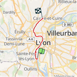
Ruta Senderismo de 10,5 km a descubrir en Auvergne-Rhône-Alpes, Métropole de Lyon, Lyon. Esta ruta ha sido propuesta por ANDREJAC.
Descripción
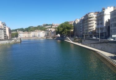
Départ du Pont Pasteur rive droite, arrêt du tramway T1.
Remontée de la Saône rive gauche jusqu'à l'Ile Barbe.
Franchissement de la Saône par le pont de l'Ile Barbe.
Localización
País:
France
Región :
Auvergne-Rhône-Alpes
Departamento/provincia :
Métropole de Lyon
Municipio :
Lyon
Localidad:
Lyon 2e Arrondissement
Salida:(Dec)
Salida:(UTM)
641511 ; 5066061 (31T) N.
Comentarios
Excursiones cerca
![Excursión Senderismo Lyon - 69-Lyon-murs-peints-musée-Tony-Garnier-mai21 - Photo](https://media.geolcdn.com/t/375/260/b5addc37-d1ea-430e-a818-e75353872d12.jpg&format=jpg&maxdim=2)
![Senderismo Senderismo](https://static1.geolcdn.com/sitytour/trail-icons/101.png)
69-Lyon-murs-peints-musée-Tony-Garnier-mai21
Senderismo
Fácil
(1)
Lyon,
Auvergne-Rhône-Alpes,
Métropole de Lyon,
France
![](/images/other/stat-length.png)
3,7 km | 4 km-effort
1h 37min
![](https://static1.geolcdn.com/siteimages/upload/files/16400158638029165_repeat_loop_refresh_sync_direction_icon.png)
Sí
![Excursión Bici de montaña Lyon - Mont Verdun - Photo](https://media.geolcdn.com/t/375/260/ext.jpg?maxdim=2&url=https%3A%2F%2Fservices.sitytrail.com%2FGeolivesWS%2FDownloadMedia.ashx%3FTrailID%3D101348%26Media%3D948_1.jpg)
![Bici de montaña Bici de montaña](https://static1.geolcdn.com/sitytour/trail-icons/202.png)
Mont Verdun
Bici de montaña
Difícil
(2)
Lyon,
Auvergne-Rhône-Alpes,
Métropole de Lyon,
France
![](/images/other/stat-length.png)
29 km | 37 km-effort
2h 15min
![](https://static1.geolcdn.com/siteimages/upload/files/16400158638029165_repeat_loop_refresh_sync_direction_icon.png)
Sí
![Excursión Senderismo Lyon - De Place des Archives à Monplaisir - Photo](https://media.geolcdn.com/t/375/260/ext.jpg?maxdim=2&url=https%3A%2F%2Fstatic1.geolcdn.com%2Fsiteimages%2Fupload%2Ffiles%2F1553511878bg_sport_marche.png)
![Senderismo Senderismo](https://static1.geolcdn.com/sitytour/trail-icons/101.png)
De Place des Archives à Monplaisir
Senderismo
Difícil
(1)
Lyon,
Auvergne-Rhône-Alpes,
Métropole de Lyon,
France
![](/images/other/stat-length.png)
11,2 km | 12,9 km-effort
2h 55min
![](https://static1.geolcdn.com/siteimages/upload/files/16400158638029165_repeat_loop_refresh_sync_direction_icon.png)
No
![Excursión Senderismo Francheville - Aqueduc et fort du Bruissin (PR1) - Photo](https://media.geolcdn.com/t/375/260/3e156afe-0a53-4173-8a16-0a0e11f72681.jpg&format=jpg&maxdim=2)
![Senderismo Senderismo](https://static1.geolcdn.com/sitytour/trail-icons/101.png)
Aqueduc et fort du Bruissin (PR1)
Senderismo
Fácil
Francheville,
Auvergne-Rhône-Alpes,
Métropole de Lyon,
France
![](/images/other/stat-length.png)
19,1 km | 23 km-effort
5h 20min
![](https://static1.geolcdn.com/siteimages/upload/files/16400158638029165_repeat_loop_refresh_sync_direction_icon.png)
Sí
![Excursión Senderismo Chaponost - de Chaponost à Brignais AR - Photo](https://media.geolcdn.com/t/375/260/748757ec-45c0-4bb1-82f9-93d25db52f90.jpg&format=jpg&maxdim=2)
![Senderismo Senderismo](https://static1.geolcdn.com/sitytour/trail-icons/101.png)
de Chaponost à Brignais AR
Senderismo
Difícil
Chaponost,
Auvergne-Rhône-Alpes,
Ródano,
France
![](/images/other/stat-length.png)
11,8 km | 14,3 km-effort
2h 40min
![](https://static1.geolcdn.com/siteimages/upload/files/16400158638029165_repeat_loop_refresh_sync_direction_icon.png)
Sí
![Excursión Senderismo Chaponost - Chaponost boucle - Photo](https://media.geolcdn.com/t/375/260/b687906a-573a-4707-b2a1-585e616585f2.jpg&format=jpg&maxdim=2)
![Senderismo Senderismo](https://static1.geolcdn.com/sitytour/trail-icons/101.png)
Chaponost boucle
Senderismo
Medio
Chaponost,
Auvergne-Rhône-Alpes,
Ródano,
France
![](/images/other/stat-length.png)
9,2 km | 11,2 km-effort
1h 56min
![](https://static1.geolcdn.com/siteimages/upload/files/16400158638029165_repeat_loop_refresh_sync_direction_icon.png)
Sí
![Excursión Senderismo Chaponost - Acqueducs de Chaponost à Beaunant - Photo](https://media.geolcdn.com/t/375/260/ef970cfb-3fa6-4f76-aabf-a3009ce76612.jpg&format=jpg&maxdim=2)
![Senderismo Senderismo](https://static1.geolcdn.com/sitytour/trail-icons/101.png)
Acqueducs de Chaponost à Beaunant
Senderismo
Medio
Chaponost,
Auvergne-Rhône-Alpes,
Ródano,
France
![](/images/other/stat-length.png)
7 km | 9,2 km-effort
1h 35min
![](https://static1.geolcdn.com/siteimages/upload/files/16400158638029165_repeat_loop_refresh_sync_direction_icon.png)
Sí
![Excursión Senderismo Sainte-Foy-lès-Lyon - Sainte foy les lyon - Photo](https://media.geolcdn.com/t/375/260/ext.jpg?maxdim=2&url=https%3A%2F%2Fstatic1.geolcdn.com%2Fsiteimages%2Fupload%2Ffiles%2F1553511878bg_sport_marche.png)
![Senderismo Senderismo](https://static1.geolcdn.com/sitytour/trail-icons/101.png)
Sainte foy les lyon
Senderismo
Difícil
(1)
Sainte-Foy-lès-Lyon,
Auvergne-Rhône-Alpes,
Métropole de Lyon,
France
![](/images/other/stat-length.png)
9,9 km | 13,2 km-effort
2h 52min
![](https://static1.geolcdn.com/siteimages/upload/files/16400158638029165_repeat_loop_refresh_sync_direction_icon.png)
Sí
![Excursión Senderismo Lyon - Lyon autour de la traboule des voraces - Photo](https://media.geolcdn.com/t/375/260/1de2654d-9234-4309-b6e6-d12141c38034.jpg&format=jpg&maxdim=2)
![Senderismo Senderismo](https://static1.geolcdn.com/sitytour/trail-icons/101.png)
Lyon autour de la traboule des voraces
Senderismo
Muy fácil
Lyon,
Auvergne-Rhône-Alpes,
Métropole de Lyon,
France
![](/images/other/stat-length.png)
4,1 km | 5,6 km-effort
1h 44min
![](https://static1.geolcdn.com/siteimages/upload/files/16400158638029165_repeat_loop_refresh_sync_direction_icon.png)
Sí