![](/images/other/stat-length.png)
![Excursión Senderismo Chambry - Chambry 16.4 km - Photo](https://media.geolcdn.com/t/1900/400/ext.pjpeg?maxdim=2&url=https%3A%2F%2Fstatic1.geolcdn.com%2Fsiteimages%2Fupload%2Ffiles%2F1553511878bg_sport_marche.png)
Chambry 16.4 km
GOELERANDO2
Usuario
![Longitud](/images/other/stat-length.png)
Longitud
16,4 km
![Altitud máxima](https://static1.geolcdn.com/siteimages/upload/files/1508320355ic_sort_altitude_max_24dp.png)
Altitud máxima
149 m
![Desnivel positivo](https://static1.geolcdn.com/siteimages/upload/files/1508320355ic_sort_den_pos_24dp.png)
Desnivel positivo
159 m
![Km-Effort](/images/other/stat-length.png)
Km-Effort
18,5 km
![Altitud mínima](https://static1.geolcdn.com/siteimages/upload/files/1508320355ic_sort_altitude_min_24dp.png)
Altitud mínima
83 m
![Desnivel negativo](https://static1.geolcdn.com/siteimages/upload/files/1508320355ic_sort_den_neg_24dp.png)
Desnivel negativo
161 m
![Boucle](https://static1.geolcdn.com/siteimages/upload/files/16400158638029165_repeat_loop_refresh_sync_direction_icon.png)
Boucle
Sí
Fecha de creación :
2016-10-24 00:00:00.0
Última modificación :
2016-10-24 00:00:00.0
![Senderismo](https://static1.geolcdn.com/sitytour/trail-icons/101.png)
4h02
Dificultad : Medio
![Escanee este código QR para abrir la excursión en la aplicación SityTrail](https://capi.geolives.com/qq0zvz2zws4bq2lad0pu/sitytour/trails/650483/qr.png?size=200)
Aplicación GPS de excursión GRATIS
A propósito
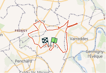
Ruta Senderismo de 16,4 km a descubrir en Isla de Francia, Sena y Marne, Chambry. Esta ruta ha sido propuesta por GOELERANDO2.
Descripción
Parking et départ de la Mairie de Chambly.
IGN 2513 OT
Lat. 48°59'54" N
Long. 2°53'37" E
A/R 38 km
Localización
País:
France
Región :
Isla de Francia
Departamento/provincia :
Sena y Marne
Municipio :
Chambry
Localidad:
Unknown
Salida:(Dec)
Salida:(UTM)
492165 ; 5427209 (31U) N.
Comentarios
Excursiones cerca
![Excursión Senderismo Crégy-lès-Meaux - SM_CREGY-LES-MEAUX_8Km - Photo](https://media.geolcdn.com/t/375/260/4a1646b8-cb34-4e33-b775-fb442311006b.jpg&format=jpg&maxdim=2)
![Senderismo Senderismo](https://static1.geolcdn.com/sitytour/trail-icons/101.png)
SM_CREGY-LES-MEAUX_8Km
Senderismo
Medio
(8)
Crégy-lès-Meaux,
Isla de Francia,
Sena y Marne,
France
![](/images/other/stat-length.png)
7,8 km | 9,2 km-effort
2h 5min
![](https://static1.geolcdn.com/siteimages/upload/files/16400158638029165_repeat_loop_refresh_sync_direction_icon.png)
Sí
![Excursión Senderismo Monthyon - MR_MONTHYON_5.4Km - Photo](https://media.geolcdn.com/t/375/260/c92ecfa9-9d4d-4956-bac2-5b8e6acac2e2.jpg&format=jpg&maxdim=2)
![Senderismo Senderismo](https://static1.geolcdn.com/sitytour/trail-icons/101.png)
MR_MONTHYON_5.4Km
Senderismo
Medio
(1)
Monthyon,
Isla de Francia,
Sena y Marne,
France
![](/images/other/stat-length.png)
5,4 km | 6,4 km-effort
1h 24min
![](https://static1.geolcdn.com/siteimages/upload/files/16400158638029165_repeat_loop_refresh_sync_direction_icon.png)
Sí
![Excursión Senderismo Meaux - Le chemin de St Colomban en Ile de France Etape 3 Jouarre Meaux - Photo](https://media.geolcdn.com/t/375/260/17b30d06-8e11-4bee-afb1-3cf425f57ffe.jpg&format=jpg&maxdim=2)
![Senderismo Senderismo](https://static1.geolcdn.com/sitytour/trail-icons/101.png)
Le chemin de St Colomban en Ile de France Etape 3 Jouarre Meaux
Senderismo
Muy difícil
Meaux,
Isla de Francia,
Sena y Marne,
France
![](/images/other/stat-length.png)
36 km | 43 km-effort
9h 41min
![](https://static1.geolcdn.com/siteimages/upload/files/16400158638029165_repeat_loop_refresh_sync_direction_icon.png)
No
![Excursión Senderismo Trilport - SityTrail - GR15-07 Trilport à - Photo](https://media.geolcdn.com/t/375/260/ext.jpg?maxdim=2&url=https%3A%2F%2Fstatic1.geolcdn.com%2Fsiteimages%2Fupload%2Ffiles%2F1553511878bg_sport_marche.png)
![Senderismo Senderismo](https://static1.geolcdn.com/sitytour/trail-icons/101.png)
SityTrail - GR15-07 Trilport à
Senderismo
Difícil
(1)
Trilport,
Isla de Francia,
Sena y Marne,
France
![](/images/other/stat-length.png)
10,6 km | 12,7 km-effort
2h 52min
![](https://static1.geolcdn.com/siteimages/upload/files/16400158638029165_repeat_loop_refresh_sync_direction_icon.png)
No
![Excursión Senderismo Meaux - SityTrail - GR15 ttrace - Photo](https://media.geolcdn.com/t/375/260/ext.jpg?maxdim=2&url=https%3A%2F%2Fstatic1.geolcdn.com%2Fsiteimages%2Fupload%2Ffiles%2F1553511878bg_sport_marche.png)
![Senderismo Senderismo](https://static1.geolcdn.com/sitytour/trail-icons/101.png)
SityTrail - GR15 ttrace
Senderismo
Difícil
(1)
Meaux,
Isla de Francia,
Sena y Marne,
France
![](/images/other/stat-length.png)
15,7 km | 18,6 km-effort
4h 13min
![](https://static1.geolcdn.com/siteimages/upload/files/16400158638029165_repeat_loop_refresh_sync_direction_icon.png)
No
![Excursión Senderismo Meaux - Le tour du Grand Paris via le GR1 - Etape 10 Meaux Mortcerf - Photo](https://media.geolcdn.com/t/375/260/bf5605a3-71d6-489a-a1f1-655ab44fd4d2.jpg&format=jpg&maxdim=2)
![Senderismo Senderismo](https://static1.geolcdn.com/sitytour/trail-icons/101.png)
Le tour du Grand Paris via le GR1 - Etape 10 Meaux Mortcerf
Senderismo
Difícil
Meaux,
Isla de Francia,
Sena y Marne,
France
![](/images/other/stat-length.png)
34 km | 40 km-effort
6h 35min
![](https://static1.geolcdn.com/siteimages/upload/files/16400158638029165_repeat_loop_refresh_sync_direction_icon.png)
No
![Excursión Senderismo Étrépilly - Etrepilly Grand parcours - Photo](https://media.geolcdn.com/t/375/260/ext.jpg?maxdim=2&url=https%3A%2F%2Fstatic1.geolcdn.com%2Fsiteimages%2Fupload%2Ffiles%2F1553511878bg_sport_marche.png)
![Senderismo Senderismo](https://static1.geolcdn.com/sitytour/trail-icons/101.png)
Etrepilly Grand parcours
Senderismo
Fácil
(1)
Étrépilly,
Isla de Francia,
Sena y Marne,
France
![](/images/other/stat-length.png)
19,3 km | 22 km-effort
5h 0min
![](https://static1.geolcdn.com/siteimages/upload/files/16400158638029165_repeat_loop_refresh_sync_direction_icon.png)
Sí
![Excursión Senderismo Chambry - Chambry Grand Parcours - Photo](https://media.geolcdn.com/t/375/260/ext.jpg?maxdim=2&url=https%3A%2F%2Fstatic1.geolcdn.com%2Fsiteimages%2Fupload%2Ffiles%2F1553511878bg_sport_marche.png)
![Senderismo Senderismo](https://static1.geolcdn.com/sitytour/trail-icons/101.png)
Chambry Grand Parcours
Senderismo
Fácil
(2)
Chambry,
Isla de Francia,
Sena y Marne,
France
![](/images/other/stat-length.png)
18,3 km | 20 km-effort
4h 29min
![](https://static1.geolcdn.com/siteimages/upload/files/16400158638029165_repeat_loop_refresh_sync_direction_icon.png)
Sí
![Excursión Senderismo Meaux - MEAUX BOUCLE 19 KM - Photo](https://media.geolcdn.com/t/375/260/ext.jpg?maxdim=2&url=https%3A%2F%2Fstatic1.geolcdn.com%2Fsiteimages%2Fupload%2Ffiles%2F1553511878bg_sport_marche.png)
![Senderismo Senderismo](https://static1.geolcdn.com/sitytour/trail-icons/101.png)
MEAUX BOUCLE 19 KM
Senderismo
Muy fácil
(1)
Meaux,
Isla de Francia,
Sena y Marne,
France
![](/images/other/stat-length.png)
19,1 km | 22 km-effort
4h 47min
![](https://static1.geolcdn.com/siteimages/upload/files/16400158638029165_repeat_loop_refresh_sync_direction_icon.png)
Sí