![](/images/other/stat-length.png)
![Excursión Caballo Modave - MODAVE - Saint-Lambert - Photo](https://media.geolcdn.com/t/1900/400/ext.pjpeg?maxdim=2&url=https%3A%2F%2Fservices.sitytrail.com%2FGeolivesWS%2FDownloadMedia.ashx%3FTrailID%3D647584%26Media%3D97c1c91c-1b83-451c-8953-ccd2fdad3410.jpg)
MODAVE - Saint-Lambert
henrineupre
Usuario
![Longitud](/images/other/stat-length.png)
Longitud
10,2 km
![Altitud máxima](https://static1.geolcdn.com/siteimages/upload/files/1508320355ic_sort_altitude_max_24dp.png)
Altitud máxima
243 m
![Desnivel positivo](https://static1.geolcdn.com/siteimages/upload/files/1508320355ic_sort_den_pos_24dp.png)
Desnivel positivo
267 m
![Km-Effort](/images/other/stat-length.png)
Km-Effort
13,7 km
![Altitud mínima](https://static1.geolcdn.com/siteimages/upload/files/1508320355ic_sort_altitude_min_24dp.png)
Altitud mínima
133 m
![Desnivel negativo](https://static1.geolcdn.com/siteimages/upload/files/1508320355ic_sort_den_neg_24dp.png)
Desnivel negativo
265 m
![Boucle](https://static1.geolcdn.com/siteimages/upload/files/16400158638029165_repeat_loop_refresh_sync_direction_icon.png)
Boucle
Sí
![Baliza](https://services.sitytrail.com/GeolivesWS/DownloadMedia.ashx?TrailID=647584&Media=balise.png)
Baliza
Fecha de creación :
2014-12-10 00:00:00.0
Última modificación :
2019-12-16 15:59:46.473
![Caballo](https://static1.geolcdn.com/sitytour/trail-icons/300.png)
1h41
Dificultad : Medio
![Escanee este código QR para abrir la excursión en la aplicación SityTrail](https://capi.geolives.com/qq0zvz2zws4bq2lad0pu/sitytour/trails/647584/qr.png?size=200)
Aplicación GPS de excursión GRATIS
A propósito
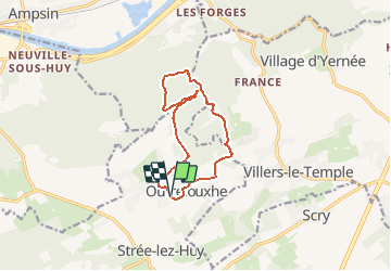
Ruta Caballo de 10,2 km a descubrir en Valonia, Lieja, Modave. Esta ruta ha sido propuesta por henrineupre.
Descripción
Au départ du manège d'Outrelouxhe, cette promenade permet aux cavaliers de parcourir de beaux chemins boisés.
BALISE: rond bleu
Sources: SIVH
Crédits photographiques: SIVH
Localización
País:
Belgium
Región :
Valonia
Departamento/provincia :
Lieja
Municipio :
Modave
Localidad:
Outrelouxhe
Salida:(Dec)
Salida:(UTM)
665244 ; 5597167 (31U) N.
Comentarios
Excursiones cerca
![Excursión Senderismo Modave - Rausa GR 575 bis - Photo](https://media.geolcdn.com/t/375/260/ext.jpg?maxdim=2&url=https%3A%2F%2Fstatic1.geolcdn.com%2Fsiteimages%2Fupload%2Ffiles%2F1553511878bg_sport_marche.png)
![Senderismo Senderismo](https://static1.geolcdn.com/sitytour/trail-icons/101.png)
Rausa GR 575 bis
Senderismo
Fácil
(12)
Modave,
Valonia,
Lieja,
Belgium
![](/images/other/stat-length.png)
6 km | 7,7 km-effort
1h 38min
![](https://static1.geolcdn.com/siteimages/upload/files/16400158638029165_repeat_loop_refresh_sync_direction_icon.png)
Sí
![Excursión Senderismo Nandrin - Villers le temple . st jean sart . clemaude - Photo](https://media.geolcdn.com/t/375/260/c7438fda-ad3c-4a12-91ed-f3aabfc6b7ce.jpg&format=jpg&maxdim=2)
![Senderismo Senderismo](https://static1.geolcdn.com/sitytour/trail-icons/101.png)
Villers le temple . st jean sart . clemaude
Senderismo
Muy fácil
(1)
Nandrin,
Valonia,
Lieja,
Belgium
![](/images/other/stat-length.png)
7,9 km | 10,4 km-effort
2h 12min
![](https://static1.geolcdn.com/siteimages/upload/files/16400158638029165_repeat_loop_refresh_sync_direction_icon.png)
Sí
![Excursión Senderismo Huy - TIHANGE (Temple Tibétain). - Photo](https://media.geolcdn.com/t/375/260/ext.jpg?maxdim=2&url=https%3A%2F%2Fservices.sitytrail.com%2FGeolivesWS%2FDownloadMedia.ashx%3FTrailID%3D458488%26Media%3Dfix__20150813122829.jpg)
![Senderismo Senderismo](https://static1.geolcdn.com/sitytour/trail-icons/101.png)
TIHANGE (Temple Tibétain).
Senderismo
Muy fácil
(2)
Huy,
Valonia,
Lieja,
Belgium
![](/images/other/stat-length.png)
11,5 km | 13,9 km-effort
3h 1min
![](https://static1.geolcdn.com/siteimages/upload/files/16400158638029165_repeat_loop_refresh_sync_direction_icon.png)
Sí
![Excursión Senderismo Modave - MODAVE - Froide Fontaine - Photo](https://media.geolcdn.com/t/375/260/ext.jpg?maxdim=2&url=https%3A%2F%2Fservices.sitytrail.com%2FGeolivesWS%2FDownloadMedia.ashx%3FTrailID%3D163540%26Media%3Da9dfd4e0-07be-4695-be31-23a02d75fa1f.jpg)
![Senderismo Senderismo](https://static1.geolcdn.com/sitytour/trail-icons/101.png)
MODAVE - Froide Fontaine
Senderismo
Medio
(2)
Modave,
Valonia,
Lieja,
Belgium
![](/images/other/stat-length.png)
8,6 km | 10,6 km-effort
2h 14min
![](https://static1.geolcdn.com/siteimages/upload/files/16400158638029165_repeat_loop_refresh_sync_direction_icon.png)
Sí
![Excursión Senderismo Nandrin - promenade de la rochette : villers le temple - grand fond d'oxhe - villers le temple - Photo](https://media.geolcdn.com/t/375/260/6a65eaf0-07ca-4e09-ab79-c1ffba2fba6b.jpg&format=jpg&maxdim=2)
![Senderismo Senderismo](https://static1.geolcdn.com/sitytour/trail-icons/101.png)
promenade de la rochette : villers le temple - grand fond d'oxhe - villers le...
Senderismo
Medio
(1)
Nandrin,
Valonia,
Lieja,
Belgium
![](/images/other/stat-length.png)
10 km | 13,3 km-effort
2h 47min
![](https://static1.geolcdn.com/siteimages/upload/files/16400158638029165_repeat_loop_refresh_sync_direction_icon.png)
Sí
![Excursión Senderismo Modave - Stree reco 21 12 - Photo](https://media.geolcdn.com/t/375/260/ext.jpg?maxdim=2&url=https%3A%2F%2Fstatic1.geolcdn.com%2Fsiteimages%2Fupload%2Ffiles%2F1553511878bg_sport_marche.png)
![Senderismo Senderismo](https://static1.geolcdn.com/sitytour/trail-icons/101.png)
Stree reco 21 12
Senderismo
Medio
(2)
Modave,
Valonia,
Lieja,
Belgium
![](/images/other/stat-length.png)
7,6 km | 9,3 km-effort
1h 55min
![](https://static1.geolcdn.com/siteimages/upload/files/16400158638029165_repeat_loop_refresh_sync_direction_icon.png)
Sí
![Excursión A pie Amay - Promenade d'Ombret - Photo](https://media.geolcdn.com/t/375/260/bbfa7314-541b-4540-af6f-869e2bd08b94.jpeg&format=jpg&maxdim=2)
![A pie A pie](https://static1.geolcdn.com/sitytour/trail-icons/100.png)
![Excursión Senderismo Huy - Tour du Bois de Tihange - Photo](https://media.geolcdn.com/t/375/260/ext.jpg?maxdim=2&url=https%3A%2F%2Fstatic1.geolcdn.com%2Fsiteimages%2Fupload%2Ffiles%2F1553511878bg_sport_marche.png)
![Senderismo Senderismo](https://static1.geolcdn.com/sitytour/trail-icons/101.png)
Tour du Bois de Tihange
Senderismo
Medio
(2)
Huy,
Valonia,
Lieja,
Belgium
![](/images/other/stat-length.png)
8,4 km | 10,4 km-effort
2h 14min
![](https://static1.geolcdn.com/siteimages/upload/files/16400158638029165_repeat_loop_refresh_sync_direction_icon.png)
Sí
![Excursión Senderismo Nandrin - Balade des bois de Yernée - Photo](https://media.geolcdn.com/t/375/260/ext.jpg?maxdim=2&url=https%3A%2F%2Fstatic1.geolcdn.com%2Fsiteimages%2Fupload%2Ffiles%2F1553511878bg_sport_marche.png)
![Senderismo Senderismo](https://static1.geolcdn.com/sitytour/trail-icons/101.png)
Balade des bois de Yernée
Senderismo
Fácil
(1)
Nandrin,
Valonia,
Lieja,
Belgium
![](/images/other/stat-length.png)
9,1 km | 11,8 km-effort
2h 9min
![](https://static1.geolcdn.com/siteimages/upload/files/16400158638029165_repeat_loop_refresh_sync_direction_icon.png)
Sí