![](/images/other/stat-length.png)
![Excursión Senderismo Trévoux - Trévoux 01 (halage) - Photo](https://media.geolcdn.com/t/1900/400/ext.pjpeg?maxdim=2&url=https%3A%2F%2Fstatic1.geolcdn.com%2Fsiteimages%2Fupload%2Ffiles%2F1553511878bg_sport_marche.png)
Trévoux 01 (halage)
Thomasdanielle
Usuario
![Longitud](/images/other/stat-length.png)
Longitud
11,4 km
![Altitud máxima](https://static1.geolcdn.com/siteimages/upload/files/1508320355ic_sort_altitude_max_24dp.png)
Altitud máxima
177 m
![Desnivel positivo](https://static1.geolcdn.com/siteimages/upload/files/1508320355ic_sort_den_pos_24dp.png)
Desnivel positivo
64 m
![Km-Effort](/images/other/stat-length.png)
Km-Effort
12,2 km
![Altitud mínima](https://static1.geolcdn.com/siteimages/upload/files/1508320355ic_sort_altitude_min_24dp.png)
Altitud mínima
165 m
![Desnivel negativo](https://static1.geolcdn.com/siteimages/upload/files/1508320355ic_sort_den_neg_24dp.png)
Desnivel negativo
64 m
![Boucle](https://static1.geolcdn.com/siteimages/upload/files/16400158638029165_repeat_loop_refresh_sync_direction_icon.png)
Boucle
Sí
Fecha de creación :
2016-11-18 00:00:00.0
Última modificación :
2016-11-18 00:00:00.0
![Senderismo](https://static1.geolcdn.com/sitytour/trail-icons/101.png)
3h31
Dificultad : Muy fácil
![Escanee este código QR para abrir la excursión en la aplicación SityTrail](https://capi.geolives.com/qq0zvz2zws4bq2lad0pu/sitytour/trails/646039/qr.png?size=200)
Aplicación GPS de excursión GRATIS
A propósito
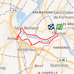
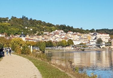
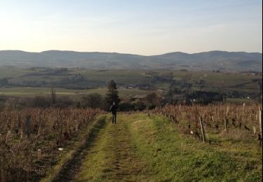
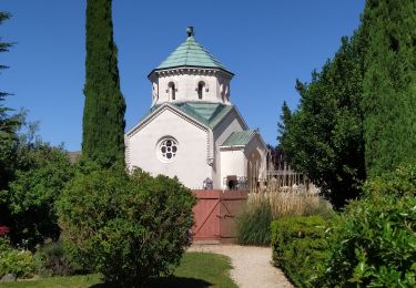
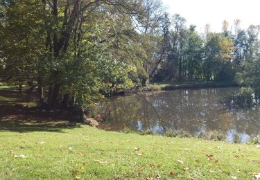
Ruta Senderismo de 11,4 km a descubrir en Auvergne-Rhône-Alpes, Ain, Trévoux. Esta ruta ha sido propuesta por Thomasdanielle.
Descripción
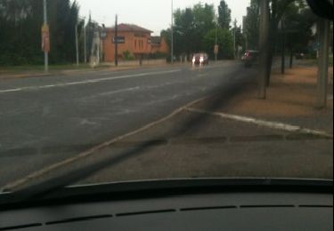
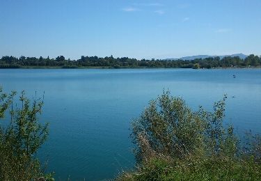
Départ grand parking près du camping. Rive droite de la Saône, rejoindre Anse, retour par St Bernard puis rive gauche de la Saône. Marche très facile et très agréable par beau temps en en Automne.
Localización
País:
France
Región :
Auvergne-Rhône-Alpes
Departamento/provincia :
Ain
Municipio :
Trévoux
Localidad:
Unknown
Salida:(Dec)
Salida:(UTM)
637159 ; 5088965 (31T) N.
Comentarios
Excursiones cerca
![Excursión Senderismo Villefranche-sur-Saône - Itinérant Beaujolais etape 1 Villefranche sur Saone - Le Flagolet - Photo](https://media.geolcdn.com/t/375/260/265892a0-89c7-47ac-89f3-06f9bc929d8c.jpg&format=jpg&maxdim=2)
![Senderismo Senderismo](https://static1.geolcdn.com/sitytour/trail-icons/101.png)
Itinérant Beaujolais etape 1 Villefranche sur Saone - Le Flagolet
Senderismo
Medio
Villefranche-sur-Saône,
Auvergne-Rhône-Alpes,
Ródano,
France
![](/images/other/stat-length.png)
20 km | 25 km-effort
4h 43min
![](https://static1.geolcdn.com/siteimages/upload/files/16400158638029165_repeat_loop_refresh_sync_direction_icon.png)
No
![Excursión Paseo ecuestre Quincieux - Quincieux 2-SGMO 19k - Photo](https://media.geolcdn.com/t/375/260/ext.jpg?maxdim=2&url=https%3A%2F%2Fstatic1.geolcdn.com%2Fsiteimages%2Fupload%2Ffiles%2F1524743154cheval.jpg)
![Paseo ecuestre Paseo ecuestre](https://static1.geolcdn.com/sitytour/trail-icons/301.png)
Quincieux 2-SGMO 19k
Paseo ecuestre
Medio
(1)
Quincieux,
Auvergne-Rhône-Alpes,
Métropole de Lyon,
France
![](/images/other/stat-length.png)
19,4 km | 21 km-effort
2h 40min
![](https://static1.geolcdn.com/siteimages/upload/files/16400158638029165_repeat_loop_refresh_sync_direction_icon.png)
No
![Excursión Caballo Quincieux - Quicieux2-SGMO 17k - Photo](https://media.geolcdn.com/t/375/260/ext.jpg?maxdim=2&url=https%3A%2F%2Fstatic1.geolcdn.com%2Fsiteimages%2Fupload%2Ffiles%2F1524743154cheval.jpg)
![Caballo Caballo](https://static1.geolcdn.com/sitytour/trail-icons/300.png)
Quicieux2-SGMO 17k
Caballo
Muy fácil
(1)
Quincieux,
Auvergne-Rhône-Alpes,
Métropole de Lyon,
France
![](/images/other/stat-length.png)
17,1 km | 19,1 km-effort
Desconocido
![](https://static1.geolcdn.com/siteimages/upload/files/16400158638029165_repeat_loop_refresh_sync_direction_icon.png)
No
![Excursión Senderismo Trévoux - TREVOUX - 01 - Photo](https://media.geolcdn.com/t/375/260/ext.jpg?maxdim=2&url=https%3A%2F%2Fservices.sitytrail.com%2FGeolivesWS%2FDownloadMedia.ashx%3FTrailID%3D646040%26Media%3Dfix__20161015165140.jpg)
![Senderismo Senderismo](https://static1.geolcdn.com/sitytour/trail-icons/101.png)
TREVOUX - 01
Senderismo
Muy fácil
Trévoux,
Auvergne-Rhône-Alpes,
Ain,
France
![](/images/other/stat-length.png)
11,7 km | 12,6 km-effort
3h 26min
![](https://static1.geolcdn.com/siteimages/upload/files/16400158638029165_repeat_loop_refresh_sync_direction_icon.png)
Sí
![Excursión Senderismo Anse - anse - Photo](https://media.geolcdn.com/t/375/260/ext.jpg?maxdim=2&url=https%3A%2F%2Fservices.sitytrail.com%2FGeolivesWS%2FDownloadMedia.ashx%3FTrailID%3D213392%26Media%3Dfix__20130815144258.jpg)
![Senderismo Senderismo](https://static1.geolcdn.com/sitytour/trail-icons/101.png)
anse
Senderismo
Muy fácil
Anse,
Auvergne-Rhône-Alpes,
Ródano,
France
![](/images/other/stat-length.png)
3,9 km | 4,3 km-effort
47min
![](https://static1.geolcdn.com/siteimages/upload/files/16400158638029165_repeat_loop_refresh_sync_direction_icon.png)
No
![Excursión Senderismo Limas - Limas - Photo](https://media.geolcdn.com/t/375/260/ext.jpg?maxdim=2&url=https%3A%2F%2Fservices.sitytrail.com%2FGeolivesWS%2FDownloadMedia.ashx%3FTrailID%3D166962%26Media%3D20121223151415.jpg)
![Senderismo Senderismo](https://static1.geolcdn.com/sitytour/trail-icons/101.png)
Limas
Senderismo
Fácil
Limas,
Auvergne-Rhône-Alpes,
Ródano,
France
![](/images/other/stat-length.png)
5,7 km | 7,6 km-effort
1h 37min
![](https://static1.geolcdn.com/siteimages/upload/files/16400158638029165_repeat_loop_refresh_sync_direction_icon.png)
Sí
![Excursión Senderismo Trévoux - ars - Photo](https://media.geolcdn.com/t/375/260/f3ea76f0-33ca-4a81-9285-0d2161b2cdd0.jpg&format=jpg&maxdim=2)
![Senderismo Senderismo](https://static1.geolcdn.com/sitytour/trail-icons/101.png)
ars
Senderismo
Difícil
Trévoux,
Auvergne-Rhône-Alpes,
Ain,
France
![](/images/other/stat-length.png)
12,6 km | 15 km-effort
4h 35min
![](https://static1.geolcdn.com/siteimages/upload/files/16400158638029165_repeat_loop_refresh_sync_direction_icon.png)
No
![Excursión Senderismo Jassans-Riottier - de Jassans à Ars - Photo](https://media.geolcdn.com/t/375/260/69609df8-c7a8-4c16-85d6-78de1862e8ac.jpg&format=jpg&maxdim=2)
![Senderismo Senderismo](https://static1.geolcdn.com/sitytour/trail-icons/101.png)
de Jassans à Ars
Senderismo
Muy fácil
Jassans-Riottier,
Auvergne-Rhône-Alpes,
Ain,
France
![](/images/other/stat-length.png)
19,5 km | 23 km-effort
6h 1min
![](https://static1.geolcdn.com/siteimages/upload/files/16400158638029165_repeat_loop_refresh_sync_direction_icon.png)
Sí
![Excursión Caballo Trévoux - test - Photo](https://media.geolcdn.com/t/375/260/ext.jpg?maxdim=2&url=https%3A%2F%2Fservices.sitytrail.com%2FGeolivesWS%2FDownloadMedia.ashx%3FTrailID%3D129367%26Media%3D20120522195952.jpg)
![Caballo Caballo](https://static1.geolcdn.com/sitytour/trail-icons/300.png)