![](/images/other/stat-length.png)
![Excursión Senderismo Chirols - Trace_Chirols_Roumegière_Sainte-Marguerite - Photo](https://media.geolcdn.com/t/1900/400/ext.pjpeg?maxdim=2&url=https%3A%2F%2Fstatic1.geolcdn.com%2Fsiteimages%2Fupload%2Ffiles%2F1553511878bg_sport_marche.png)
Trace_Chirols_Roumegière_Sainte-Marguerite
coureursdecretes
Usuario
![Longitud](/images/other/stat-length.png)
Longitud
12,4 km
![Altitud máxima](https://static1.geolcdn.com/siteimages/upload/files/1508320355ic_sort_altitude_max_24dp.png)
Altitud máxima
982 m
![Desnivel positivo](https://static1.geolcdn.com/siteimages/upload/files/1508320355ic_sort_den_pos_24dp.png)
Desnivel positivo
716 m
![Km-Effort](/images/other/stat-length.png)
Km-Effort
22 km
![Altitud mínima](https://static1.geolcdn.com/siteimages/upload/files/1508320355ic_sort_altitude_min_24dp.png)
Altitud mínima
341 m
![Desnivel negativo](https://static1.geolcdn.com/siteimages/upload/files/1508320355ic_sort_den_neg_24dp.png)
Desnivel negativo
711 m
![Boucle](https://static1.geolcdn.com/siteimages/upload/files/16400158638029165_repeat_loop_refresh_sync_direction_icon.png)
Boucle
Sí
Fecha de creación :
2016-10-09 00:00:00.0
Última modificación :
2021-09-27 18:25:40.244
![Senderismo](https://static1.geolcdn.com/sitytour/trail-icons/101.png)
4h36
Dificultad : Difícil
![Escanee este código QR para abrir la excursión en la aplicación SityTrail](https://capi.geolives.com/qq0zvz2zws4bq2lad0pu/sitytour/trails/643667/qr.png?size=200)
Aplicación GPS de excursión GRATIS
A propósito
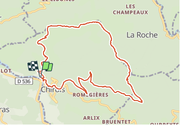
Ruta Senderismo de 12,4 km a descubrir en Auvergne-Rhône-Alpes, Ardecha, Chirols. Esta ruta ha sido propuesta por coureursdecretes.
Descripción
Le sens de la trace est plus sympa, avec plus de vue que le sens inverse.
S'assurer que le sentier entre le Col des Monges et le col des Champs n'est pas fermé par la végétation.
Localización
País:
France
Región :
Auvergne-Rhône-Alpes
Departamento/provincia :
Ardecha
Municipio :
Chirols
Localidad:
Unknown
Salida:(Dec)
Salida:(UTM)
601696 ; 4949089 (31T) N.
Comentarios
Excursiones cerca
![Excursión Senderismo Labastide-sur-Bésorgues - 2022-02-01_15h56m32_Les granges de Sausses 14,5km.GPX.xml - Photo](https://media.geolcdn.com/t/375/260/f7fbac7a-11f7-4ce8-b0bf-02f788ab9e07.jpg&format=jpg&maxdim=2)
![Senderismo Senderismo](https://static1.geolcdn.com/sitytour/trail-icons/101.png)
2022-02-01_15h56m32_Les granges de Sausses 14,5km.GPX.xml
Senderismo
Difícil
(1)
Labastide-sur-Bésorgues,
Auvergne-Rhône-Alpes,
Ardecha,
France
![](/images/other/stat-length.png)
14,1 km | 24 km-effort
5h 37min
![](https://static1.geolcdn.com/siteimages/upload/files/16400158638029165_repeat_loop_refresh_sync_direction_icon.png)
Sí
![Excursión Senderismo Vallées-d'Antraigues-Asperjoc - 07 antraigues - Photo](https://media.geolcdn.com/t/375/260/59713960-36e0-4cc2-a246-618043d58544.jpg&format=jpg&maxdim=2)
![Senderismo Senderismo](https://static1.geolcdn.com/sitytour/trail-icons/101.png)
07 antraigues
Senderismo
Difícil
Vallées-d'Antraigues-Asperjoc,
Auvergne-Rhône-Alpes,
Ardecha,
France
![](/images/other/stat-length.png)
14,4 km | 24 km-effort
7h 0min
![](https://static1.geolcdn.com/siteimages/upload/files/16400158638029165_repeat_loop_refresh_sync_direction_icon.png)
Sí
![Excursión Senderismo Saint-Pierre-de-Colombier - SityTrail - 2775482 - st-pierre-burzet - Photo](https://media.geolcdn.com/t/375/260/ext.jpg?maxdim=2&url=https%3A%2F%2Fstatic1.geolcdn.com%2Fsiteimages%2Fupload%2Ffiles%2F1553511878bg_sport_marche.png)
![Senderismo Senderismo](https://static1.geolcdn.com/sitytour/trail-icons/101.png)
SityTrail - 2775482 - st-pierre-burzet
Senderismo
Muy difícil
(1)
Saint-Pierre-de-Colombier,
Auvergne-Rhône-Alpes,
Ardecha,
France
![](/images/other/stat-length.png)
11,5 km | 17,1 km-effort
4h 45min
![](https://static1.geolcdn.com/siteimages/upload/files/16400158638029165_repeat_loop_refresh_sync_direction_icon.png)
Sí
![Excursión Senderismo Aizac - SityTrail - 2231069 - aizacxmal-combexla-bastide-sur-besorgue- - Photo](https://media.geolcdn.com/t/375/260/ext.jpg?maxdim=2&url=https%3A%2F%2Fstatic1.geolcdn.com%2Fsiteimages%2Fupload%2Ffiles%2F1553511878bg_sport_marche.png)
![Senderismo Senderismo](https://static1.geolcdn.com/sitytour/trail-icons/101.png)
SityTrail - 2231069 - aizacxmal-combexla-bastide-sur-besorgue-
Senderismo
Difícil
(1)
Aizac,
Auvergne-Rhône-Alpes,
Ardecha,
France
![](/images/other/stat-length.png)
10,3 km | 17,4 km-effort
3h 57min
![](https://static1.geolcdn.com/siteimages/upload/files/16400158638029165_repeat_loop_refresh_sync_direction_icon.png)
Sí
![Excursión Senderismo Fabras - Fabras - Photo](https://media.geolcdn.com/t/375/260/ext.jpg?maxdim=2&url=https%3A%2F%2Fstatic1.geolcdn.com%2Fsiteimages%2Fupload%2Ffiles%2F1553511878bg_sport_marche.png)
![Senderismo Senderismo](https://static1.geolcdn.com/sitytour/trail-icons/101.png)
Fabras
Senderismo
Medio
(1)
Fabras,
Auvergne-Rhône-Alpes,
Ardecha,
France
![](/images/other/stat-length.png)
6,4 km | 9,7 km-effort
1h 49min
![](https://static1.geolcdn.com/siteimages/upload/files/16400158638029165_repeat_loop_refresh_sync_direction_icon.png)
No
![Excursión Senderismo Aizac - Aizac et la coupe d'Aizac - Photo](https://media.geolcdn.com/t/375/260/ext.jpg?maxdim=2&url=https%3A%2F%2Fstatic1.geolcdn.com%2Fsiteimages%2Fupload%2Ffiles%2F1553511878bg_sport_marche.png)
![Senderismo Senderismo](https://static1.geolcdn.com/sitytour/trail-icons/101.png)
Aizac et la coupe d'Aizac
Senderismo
Fácil
(1)
Aizac,
Auvergne-Rhône-Alpes,
Ardecha,
France
![](/images/other/stat-length.png)
4,5 km | 7,5 km-effort
1h 24min
![](https://static1.geolcdn.com/siteimages/upload/files/16400158638029165_repeat_loop_refresh_sync_direction_icon.png)
Sí
![Excursión Senderismo Meyras - neyrac les bains - Photo](https://media.geolcdn.com/t/375/260/ext.jpg?maxdim=2&url=https%3A%2F%2Fstatic1.geolcdn.com%2Fsiteimages%2Fupload%2Ffiles%2F1553511878bg_sport_marche.png)
![Senderismo Senderismo](https://static1.geolcdn.com/sitytour/trail-icons/101.png)
neyrac les bains
Senderismo
Fácil
(1)
Meyras,
Auvergne-Rhône-Alpes,
Ardecha,
France
![](/images/other/stat-length.png)
4,4 km | 6,8 km-effort
1h 36min
![](https://static1.geolcdn.com/siteimages/upload/files/16400158638029165_repeat_loop_refresh_sync_direction_icon.png)
Sí
![Excursión Senderismo Chirols - Ste Marguerite - Photo](https://media.geolcdn.com/t/375/260/ext.jpg?maxdim=2&url=https%3A%2F%2Fstatic1.geolcdn.com%2Fsiteimages%2Fupload%2Ffiles%2F1553511878bg_sport_marche.png)
![Senderismo Senderismo](https://static1.geolcdn.com/sitytour/trail-icons/101.png)
Ste Marguerite
Senderismo
Medio
(2)
Chirols,
Auvergne-Rhône-Alpes,
Ardecha,
France
![](/images/other/stat-length.png)
12,7 km | 22 km-effort
3h 57min
![](https://static1.geolcdn.com/siteimages/upload/files/16400158638029165_repeat_loop_refresh_sync_direction_icon.png)
Sí
![Excursión Senderismo Thueyts - 231217 Thueyts-Brige - Photo](https://media.geolcdn.com/t/375/260/ext.jpg?maxdim=2&url=https%3A%2F%2Fstatic1.geolcdn.com%2Fsiteimages%2Fupload%2Ffiles%2F1553511878bg_sport_marche.png)
![Senderismo Senderismo](https://static1.geolcdn.com/sitytour/trail-icons/101.png)
231217 Thueyts-Brige
Senderismo
Fácil
(1)
Thueyts,
Auvergne-Rhône-Alpes,
Ardecha,
France
![](/images/other/stat-length.png)
5,7 km | 9,6 km-effort
2h 11min
![](https://static1.geolcdn.com/siteimages/upload/files/16400158638029165_repeat_loop_refresh_sync_direction_icon.png)
Sí