![](/images/other/stat-length.png)
![Excursión Caballo Friesenheim - 2016-09-18 [T] Balade jusqu'à Sundhouse - Photo](https://media.geolcdn.com/t/1900/400/ext.pjpeg?maxdim=2&url=https%3A%2F%2Fstatic1.geolcdn.com%2Fsiteimages%2Fupload%2Ffiles%2F1524743154cheval.jpg)
2016-09-18 [T] Balade jusqu'à Sundhouse
noelle67
Usuario
![Longitud](/images/other/stat-length.png)
Longitud
27 km
![Altitud máxima](https://static1.geolcdn.com/siteimages/upload/files/1508320355ic_sort_altitude_max_24dp.png)
Altitud máxima
173 m
![Desnivel positivo](https://static1.geolcdn.com/siteimages/upload/files/1508320355ic_sort_den_pos_24dp.png)
Desnivel positivo
159 m
![Km-Effort](/images/other/stat-length.png)
Km-Effort
29 km
![Altitud mínima](https://static1.geolcdn.com/siteimages/upload/files/1508320355ic_sort_altitude_min_24dp.png)
Altitud mínima
157 m
![Desnivel negativo](https://static1.geolcdn.com/siteimages/upload/files/1508320355ic_sort_den_neg_24dp.png)
Desnivel negativo
159 m
![Boucle](https://static1.geolcdn.com/siteimages/upload/files/16400158638029165_repeat_loop_refresh_sync_direction_icon.png)
Boucle
Sí
Fecha de creación :
2016-09-18 00:00:00.0
Última modificación :
2016-09-18 00:00:00.0
![Caballo](https://static1.geolcdn.com/sitytour/trail-icons/300.png)
4h48
Dificultad : Muy fácil
![Escanee este código QR para abrir la excursión en la aplicación SityTrail](https://capi.geolives.com/qq0zvz2zws4bq2lad0pu/sitytour/trails/632952/qr.png?size=200)
Aplicación GPS de excursión GRATIS
A propósito
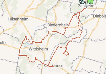
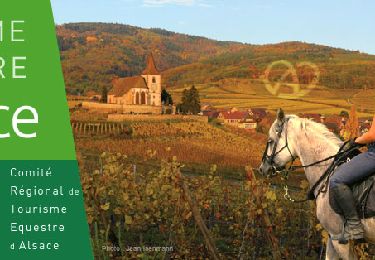
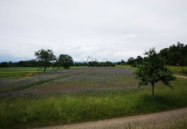
Ruta Caballo de 27 km a descubrir en Gran Este, Bajo-Rin, Friesenheim. Esta ruta ha sido propuesta por noelle67.
Descripción
Balade au départ de Zelsheim, pause de midi au restaurant "La demi-Lune" à Sundhouse.
Accueil chaleureux et endroit couvert pour les chevaux.
Localización
País:
France
Región :
Gran Este
Departamento/provincia :
Bajo-Rin
Municipio :
Friesenheim
Localidad:
Unknown
Salida:(Dec)
Salida:(UTM)
399356 ; 5350154 (32U) N.
Comentarios
Excursiones cerca
![Excursión Caballo Friesenheim - 2015-04-06 Balade des allées cavalieres - Photo](https://media.geolcdn.com/t/375/260/ext.jpg?maxdim=2&url=https%3A%2F%2Fstatic1.geolcdn.com%2Fsiteimages%2Fupload%2Ffiles%2F1524743154cheval.jpg)
![Caballo Caballo](https://static1.geolcdn.com/sitytour/trail-icons/300.png)
2015-04-06 Balade des allées cavalieres
Caballo
Fácil
(1)
Friesenheim,
Gran Este,
Bajo-Rin,
France
![](/images/other/stat-length.png)
32 km | 34 km-effort
5h 9min
![](https://static1.geolcdn.com/siteimages/upload/files/16400158638029165_repeat_loop_refresh_sync_direction_icon.png)
Sí
![Excursión Senderismo Rhinau - ile de rhinau2 - Photo](https://media.geolcdn.com/t/375/260/6953f7da-b714-49db-976c-ac41b6ea2076.jpg&format=jpg&maxdim=2)
![Senderismo Senderismo](https://static1.geolcdn.com/sitytour/trail-icons/101.png)
ile de rhinau2
Senderismo
Medio
Rhinau,
Gran Este,
Bajo-Rin,
France
![](/images/other/stat-length.png)
10,4 km | 11,6 km-effort
2h 45min
![](https://static1.geolcdn.com/siteimages/upload/files/16400158638029165_repeat_loop_refresh_sync_direction_icon.png)
No
![Excursión Senderismo Rhinau - Île de Rhinau - Photo](https://media.geolcdn.com/t/375/260/f8dee453-353a-44f4-a363-359cd1651a3e.jpg&format=jpg&maxdim=2)
![Senderismo Senderismo](https://static1.geolcdn.com/sitytour/trail-icons/101.png)
Île de Rhinau
Senderismo
Fácil
Rhinau,
Gran Este,
Bajo-Rin,
France
![](/images/other/stat-length.png)
9,3 km | 10,5 km-effort
2h 39min
![](https://static1.geolcdn.com/siteimages/upload/files/16400158638029165_repeat_loop_refresh_sync_direction_icon.png)
Sí
![Excursión Paseo ecuestre Rossfeld - Boucle Rossfeld Huttenheim Chapelle Saint Materne - Photo](https://media.geolcdn.com/t/375/260/4215acf4-dc6d-465b-8fef-f1fd0f4d0729.jpg&format=jpg&maxdim=2)
![Paseo ecuestre Paseo ecuestre](https://static1.geolcdn.com/sitytour/trail-icons/301.png)
Boucle Rossfeld Huttenheim Chapelle Saint Materne
Paseo ecuestre
Fácil
Rossfeld,
Gran Este,
Bajo-Rin,
France
![](/images/other/stat-length.png)
24 km | 26 km-effort
1h 52min
![](https://static1.geolcdn.com/siteimages/upload/files/16400158638029165_repeat_loop_refresh_sync_direction_icon.png)
Sí
![Excursión Bicicleta híbrida Friesenheim - bac rhinau - Photo](https://media.geolcdn.com/t/375/260/cd467a11-623a-40d4-8a36-0079b3da655e.jpg&format=jpg&maxdim=2)
![Bicicleta híbrida Bicicleta híbrida](https://static1.geolcdn.com/sitytour/trail-icons/203.png)
bac rhinau
Bicicleta híbrida
Muy fácil
Friesenheim,
Gran Este,
Bajo-Rin,
France
![](/images/other/stat-length.png)
47 km | 51 km-effort
6h 26min
![](https://static1.geolcdn.com/siteimages/upload/files/16400158638029165_repeat_loop_refresh_sync_direction_icon.png)
Sí
![Excursión Senderismo Rhinau - centrale électrique de Rhinau - Photo](https://media.geolcdn.com/t/375/260/ext.jpg?maxdim=2&url=https%3A%2F%2Fstatic1.geolcdn.com%2Fsiteimages%2Fupload%2Ffiles%2F1553511878bg_sport_marche.png)
![Senderismo Senderismo](https://static1.geolcdn.com/sitytour/trail-icons/101.png)
centrale électrique de Rhinau
Senderismo
Muy fácil
(1)
Rhinau,
Gran Este,
Bajo-Rin,
France
![](/images/other/stat-length.png)
4,1 km | 4,6 km-effort
2h 14min
![](https://static1.geolcdn.com/siteimages/upload/files/16400158638029165_repeat_loop_refresh_sync_direction_icon.png)
Sí
![Excursión Piragüismo Rhinau - Canoé-brunnwasser en canoé - Photo](https://media.geolcdn.com/t/375/260/ext.jpg?maxdim=2&url=https%3A%2F%2Fservices.sitytrail.com%2FGeolivesWS%2FDownloadMedia.ashx%3FTrailID%3D222036%26Media%3D1bcda2e1-6733-4de7-b73d-6a41bdee2577.jpg)
![Piragüismo Piragüismo](https://static1.geolcdn.com/sitytour/trail-icons/703.png)
Canoé-brunnwasser en canoé
Piragüismo
Muy fácil
Rhinau,
Gran Este,
Bajo-Rin,
France
![](/images/other/stat-length.png)
7 km | 7,5 km-effort
2h 0min
![](https://static1.geolcdn.com/siteimages/upload/files/16400158638029165_repeat_loop_refresh_sync_direction_icon.png)
No
![Excursión Caballo Friesenheim - 2013-06-05 Balade avec Laurent - Photo](https://media.geolcdn.com/t/375/260/ext.jpg?maxdim=2&url=https%3A%2F%2Fstatic1.geolcdn.com%2Fsiteimages%2Fupload%2Ffiles%2F1524743154cheval.jpg)
![Caballo Caballo](https://static1.geolcdn.com/sitytour/trail-icons/300.png)
2013-06-05 Balade avec Laurent
Caballo
Muy fácil
Friesenheim,
Gran Este,
Bajo-Rin,
France
![](/images/other/stat-length.png)
11,9 km | 13,1 km-effort
1h 30min
![](https://static1.geolcdn.com/siteimages/upload/files/16400158638029165_repeat_loop_refresh_sync_direction_icon.png)
Sí
![Excursión Caballo Rossfeld - 2013-05-09 Journee Allées cavalières g - Photo](https://media.geolcdn.com/t/375/260/ext.jpg?maxdim=2&url=https%3A%2F%2Fstatic1.geolcdn.com%2Fsiteimages%2Fupload%2Ffiles%2F1524743154cheval.jpg)
![Caballo Caballo](https://static1.geolcdn.com/sitytour/trail-icons/300.png)
2013-05-09 Journee Allées cavalières g
Caballo
Fácil
Rossfeld,
Gran Este,
Bajo-Rin,
France
![](/images/other/stat-length.png)
36 km | 38 km-effort
8h 16min
![](https://static1.geolcdn.com/siteimages/upload/files/16400158638029165_repeat_loop_refresh_sync_direction_icon.png)
Sí