![](/images/other/stat-length.png)
![Excursión Senderismo Aime-la-Plagne - Circuit par les cretes Dzonfie, Quermoz depuis La Combe. - Photo](https://media.geolcdn.com/t/1900/400/ext.pjpeg?maxdim=2&url=https%3A%2F%2Fservices.sitytrail.com%2FGeolivesWS%2FDownloadMedia.ashx%3FTrailID%3D629822%26Media%3D20160910133917.jpg)
Circuit par les cretes Dzonfie, Quermoz depuis La Combe.
DROCHON
Usuario
![Longitud](/images/other/stat-length.png)
Longitud
11,3 km
![Altitud máxima](https://static1.geolcdn.com/siteimages/upload/files/1508320355ic_sort_altitude_max_24dp.png)
Altitud máxima
2440 m
![Desnivel positivo](https://static1.geolcdn.com/siteimages/upload/files/1508320355ic_sort_den_pos_24dp.png)
Desnivel positivo
989 m
![Km-Effort](/images/other/stat-length.png)
Km-Effort
25 km
![Altitud mínima](https://static1.geolcdn.com/siteimages/upload/files/1508320355ic_sort_altitude_min_24dp.png)
Altitud mínima
1638 m
![Desnivel negativo](https://static1.geolcdn.com/siteimages/upload/files/1508320355ic_sort_den_neg_24dp.png)
Desnivel negativo
986 m
![Boucle](https://static1.geolcdn.com/siteimages/upload/files/16400158638029165_repeat_loop_refresh_sync_direction_icon.png)
Boucle
Sí
Fecha de creación :
2016-09-11 00:00:00.0
Última modificación :
2016-09-11 00:00:00.0
![Senderismo](https://static1.geolcdn.com/sitytour/trail-icons/101.png)
4h52
Dificultad : Fácil
![Escanee este código QR para abrir la excursión en la aplicación SityTrail](https://capi.geolives.com/qq0zvz2zws4bq2lad0pu/sitytour/trails/629822/qr.png?size=200)
Aplicación GPS de excursión GRATIS
A propósito
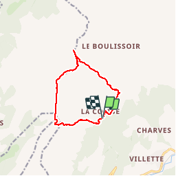
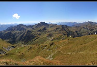
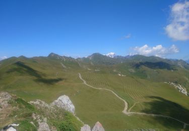
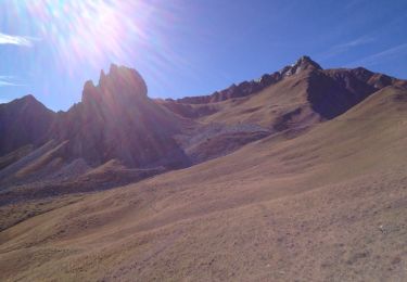
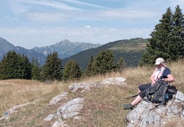
Ruta Senderismo de 11,3 km a descubrir en Auvergne-Rhône-Alpes, Saboya, Aime-la-Plagne. Esta ruta ha sido propuesta por DROCHON.
Descripción
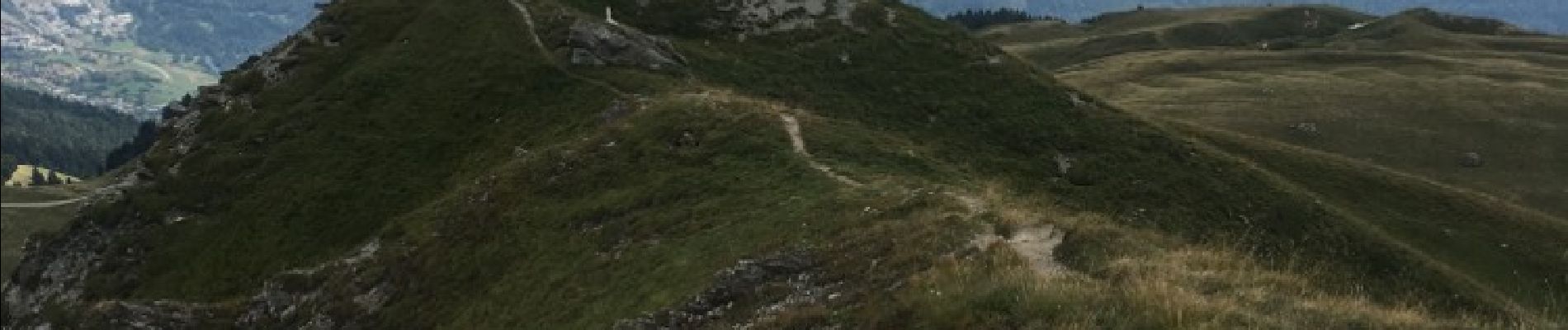
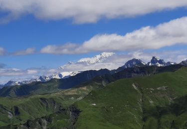
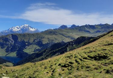
Circuit par les cretes depuis La Combe, Roche a Jonathan, pte du col, Dzonfie, Pte de Bagnaz, Quermoz et retour a La Combe.
Localización
País:
France
Región :
Auvergne-Rhône-Alpes
Departamento/provincia :
Saboya
Municipio :
Aime-la-Plagne
Localidad:
Aime
Salida:(Dec)
Salida:(UTM)
311601 ; 5048134 (32T) N.
Comentarios
Excursiones cerca
![Excursión Senderismo Aime-la-Plagne - Balcons de Granier - Photo](https://media.geolcdn.com/t/375/260/ext.jpg?maxdim=2&url=https%3A%2F%2Fstatic1.geolcdn.com%2Fsiteimages%2Fupload%2Ffiles%2F1553511878bg_sport_marche.png)
![Senderismo Senderismo](https://static1.geolcdn.com/sitytour/trail-icons/101.png)
Balcons de Granier
Senderismo
Fácil
(2)
Aime-la-Plagne,
Auvergne-Rhône-Alpes,
Saboya,
France
![](/images/other/stat-length.png)
7,3 km | 12,6 km-effort
2h 48min
![](https://static1.geolcdn.com/siteimages/upload/files/16400158638029165_repeat_loop_refresh_sync_direction_icon.png)
Sí
![Excursión Senderismo La Léchère - Col des Génisses par le refuge du Nant du Beurre - Photo](https://media.geolcdn.com/t/375/260/c621086d-e802-4fc9-b77f-57f582faf42d.jpg&format=jpg&maxdim=2)
![Senderismo Senderismo](https://static1.geolcdn.com/sitytour/trail-icons/101.png)
Col des Génisses par le refuge du Nant du Beurre
Senderismo
Muy difícil
La Léchère,
Auvergne-Rhône-Alpes,
Saboya,
France
![](/images/other/stat-length.png)
16,1 km | 28 km-effort
6h 20min
![](https://static1.geolcdn.com/siteimages/upload/files/16400158638029165_repeat_loop_refresh_sync_direction_icon.png)
Sí
![Excursión Senderismo La Léchère - lacs de la tempête - Photo](https://media.geolcdn.com/t/375/260/7ab3266a-90e4-4e18-93e8-1f9644da26a2.jpg&format=jpg&maxdim=2)
![Senderismo Senderismo](https://static1.geolcdn.com/sitytour/trail-icons/101.png)
lacs de la tempête
Senderismo
Muy difícil
La Léchère,
Auvergne-Rhône-Alpes,
Saboya,
France
![](/images/other/stat-length.png)
14,8 km | 25 km-effort
7h 10min
![](https://static1.geolcdn.com/siteimages/upload/files/16400158638029165_repeat_loop_refresh_sync_direction_icon.png)
Sí
![Excursión Senderismo Aime-la-Plagne - croix de tessins roche de janatan - Photo](https://media.geolcdn.com/t/375/260/70bd5170-f1a0-4370-a8a9-2bd84b4c62f8.jpg&format=jpg&maxdim=2)
![Senderismo Senderismo](https://static1.geolcdn.com/sitytour/trail-icons/101.png)
croix de tessins roche de janatan
Senderismo
Medio
Aime-la-Plagne,
Auvergne-Rhône-Alpes,
Saboya,
France
![](/images/other/stat-length.png)
7,4 km | 15,2 km-effort
2h 22min
![](https://static1.geolcdn.com/siteimages/upload/files/16400158638029165_repeat_loop_refresh_sync_direction_icon.png)
Sí
![Excursión Senderismo Aime-la-Plagne - Mont Coin - Photo](https://media.geolcdn.com/t/375/260/4f563390-2587-42f5-8996-ce783b07d0a6.jpg&format=jpg&maxdim=2)
![Senderismo Senderismo](https://static1.geolcdn.com/sitytour/trail-icons/101.png)
Mont Coin
Senderismo
Medio
Aime-la-Plagne,
Auvergne-Rhône-Alpes,
Saboya,
France
![](/images/other/stat-length.png)
17 km | 32 km-effort
6h 59min
![](https://static1.geolcdn.com/siteimages/upload/files/16400158638029165_repeat_loop_refresh_sync_direction_icon.png)
Sí
![Excursión Senderismo La Léchère - Tour du Quermoz par Grand Naves - Photo](https://media.geolcdn.com/t/375/260/b6009670-ce5c-4d7e-9ab7-0ee7a59863d7.jpg&format=jpg&maxdim=2)
![Senderismo Senderismo](https://static1.geolcdn.com/sitytour/trail-icons/101.png)
Tour du Quermoz par Grand Naves
Senderismo
Medio
La Léchère,
Auvergne-Rhône-Alpes,
Saboya,
France
![](/images/other/stat-length.png)
16 km | 30 km-effort
4h 30min
![](https://static1.geolcdn.com/siteimages/upload/files/16400158638029165_repeat_loop_refresh_sync_direction_icon.png)
No
![Excursión Senderismo Aime-la-Plagne - le verraret (granier) par combe bénite - Photo](https://media.geolcdn.com/t/375/260/ext.jpg?maxdim=2&url=https%3A%2F%2Fservices.sitytrail.com%2FGeolivesWS%2FDownloadMedia.ashx%3FTrailID%3D355417%26Media%3D20141019134528.jpg)
![Senderismo Senderismo](https://static1.geolcdn.com/sitytour/trail-icons/101.png)
le verraret (granier) par combe bénite
Senderismo
Difícil
Aime-la-Plagne,
Auvergne-Rhône-Alpes,
Saboya,
France
![](/images/other/stat-length.png)
13 km | 24 km-effort
4h 24min
![](https://static1.geolcdn.com/siteimages/upload/files/16400158638029165_repeat_loop_refresh_sync_direction_icon.png)
Sí
![Excursión Raquetas de nieve La Léchère - poinye du dzonfie - Photo](https://media.geolcdn.com/t/375/260/ext.jpg?maxdim=2&url=https%3A%2F%2Fservices.sitytrail.com%2FGeolivesWS%2FDownloadMedia.ashx%3FTrailID%3D175759%26Media%3D20130218114702.jpeg)
![Raquetas de nieve Raquetas de nieve](https://static1.geolcdn.com/sitytour/trail-icons/504.png)
poinye du dzonfie
Raquetas de nieve
Medio
La Léchère,
Auvergne-Rhône-Alpes,
Saboya,
France
![](/images/other/stat-length.png)
5,4 km | 12,4 km-effort
49min
![](https://static1.geolcdn.com/siteimages/upload/files/16400158638029165_repeat_loop_refresh_sync_direction_icon.png)
No
![Excursión Senderismo La Léchère - grand naves Beaufortain - Photo](https://media.geolcdn.com/t/375/260/0d5c1464-9afe-40cd-a3c1-52f7950d0659.jpg&format=jpg&maxdim=2)
![Senderismo Senderismo](https://static1.geolcdn.com/sitytour/trail-icons/101.png)
grand naves Beaufortain
Senderismo
Muy difícil
La Léchère,
Auvergne-Rhône-Alpes,
Saboya,
France
![](/images/other/stat-length.png)
12,8 km | 21 km-effort
5h 31min
![](https://static1.geolcdn.com/siteimages/upload/files/16400158638029165_repeat_loop_refresh_sync_direction_icon.png)
Sí