![](/images/other/stat-length.png)
![Excursión Senderismo Pierre-Châtel - LA PIERRE PERCÉE-PIERRE CHATEL-29-08-2016 - Photo](https://media.geolcdn.com/t/1900/400/ext.pjpeg?maxdim=2&url=https%3A%2F%2Fservices.sitytrail.com%2FGeolivesWS%2FDownloadMedia.ashx%3FTrailID%3D626118%26Media%3D20160829115908.jpg)
LA PIERRE PERCÉE-PIERRE CHATEL-29-08-2016
RD78-38
Usuario
![Longitud](/images/other/stat-length.png)
Longitud
13,6 km
![Altitud máxima](https://static1.geolcdn.com/siteimages/upload/files/1508320355ic_sort_altitude_max_24dp.png)
Altitud máxima
1275 m
![Desnivel positivo](https://static1.geolcdn.com/siteimages/upload/files/1508320355ic_sort_den_pos_24dp.png)
Desnivel positivo
445 m
![Km-Effort](/images/other/stat-length.png)
Km-Effort
19,5 km
![Altitud mínima](https://static1.geolcdn.com/siteimages/upload/files/1508320355ic_sort_altitude_min_24dp.png)
Altitud mínima
932 m
![Desnivel negativo](https://static1.geolcdn.com/siteimages/upload/files/1508320355ic_sort_den_neg_24dp.png)
Desnivel negativo
447 m
![Boucle](https://static1.geolcdn.com/siteimages/upload/files/16400158638029165_repeat_loop_refresh_sync_direction_icon.png)
Boucle
Sí
Fecha de creación :
2016-09-04 00:00:00.0
Última modificación :
2020-07-11 00:22:51.629
![Senderismo](https://static1.geolcdn.com/sitytour/trail-icons/101.png)
4h13
Dificultad : Muy fácil
![Escanee este código QR para abrir la excursión en la aplicación SityTrail](https://capi.geolives.com/qq0zvz2zws4bq2lad0pu/sitytour/trails/626118/qr.png?size=200)
Aplicación GPS de excursión GRATIS
A propósito
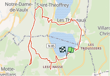
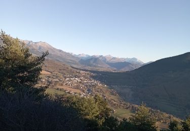
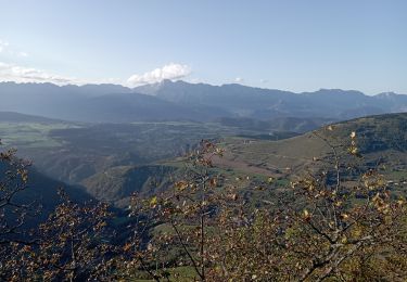
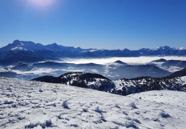
Ruta Senderismo de 13,6 km a descubrir en Auvergne-Rhône-Alpes, Isère, Pierre-Châtel. Esta ruta ha sido propuesta por RD78-38.
Descripción
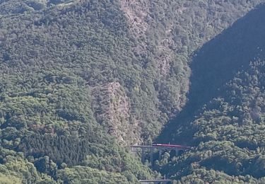
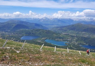
Ballade plus que Randonnée. Aller et retour vers la pierre percée sans grand intérêt (aucune vue, traversée d'une forêt seulement). Seule la pierre percée et sa vue présentent un intérêt.
Localización
País:
France
Región :
Auvergne-Rhône-Alpes
Departamento/provincia :
Isère
Municipio :
Pierre-Châtel
Localidad:
Unknown
Salida:(Dec)
Salida:(UTM)
719248 ; 4983213 (31T) N.
Comentarios
Excursiones cerca
![Excursión Bici de montaña Pierre-Châtel - Tour des lacs Pierre-Chatel - Photo](https://media.geolcdn.com/t/375/260/ext.jpg?maxdim=2&url=https%3A%2F%2Fstatic1.geolcdn.com%2Fsiteimages%2Fupload%2Ffiles%2F1524743154velo.jpg)
![Bici de montaña Bici de montaña](https://static1.geolcdn.com/sitytour/trail-icons/202.png)
Tour des lacs Pierre-Chatel
Bici de montaña
Muy fácil
(1)
Pierre-Châtel,
Auvergne-Rhône-Alpes,
Isère,
France
![](/images/other/stat-length.png)
32 km | 46 km-effort
4h 28min
![](https://static1.geolcdn.com/siteimages/upload/files/16400158638029165_repeat_loop_refresh_sync_direction_icon.png)
Sí
![Excursión Senderismo La Motte-Saint-Martin - connex - Photo](https://media.geolcdn.com/t/375/260/ext.jpg?maxdim=2&url=https%3A%2F%2Fmedia.geolcdn.com%2Ff%2F874cc892-61da-4872-9785-f7893aa41f95.jpg)
![Senderismo Senderismo](https://static1.geolcdn.com/sitytour/trail-icons/101.png)
connex
Senderismo
Medio
La Motte-Saint-Martin,
Auvergne-Rhône-Alpes,
Isère,
France
![](/images/other/stat-length.png)
15,6 km | 28 km-effort
6h 26min
![](https://static1.geolcdn.com/siteimages/upload/files/16400158638029165_repeat_loop_refresh_sync_direction_icon.png)
Sí
![Excursión Bici de montaña La Motte-d'Aveillans - Le Sénépy depuis Les Signaraux - Photo](https://media.geolcdn.com/t/375/260/ext.jpg?maxdim=2&url=https%3A%2F%2Fmedia.geolcdn.com%2Ff%2F48b7fa7e-1a2a-4b01-b381-61d2b963f1f0.jpg)
![Bici de montaña Bici de montaña](https://static1.geolcdn.com/sitytour/trail-icons/202.png)
Le Sénépy depuis Les Signaraux
Bici de montaña
Medio
La Motte-d'Aveillans,
Auvergne-Rhône-Alpes,
Isère,
France
![](/images/other/stat-length.png)
20 km | 32 km-effort
3h 39min
![](https://static1.geolcdn.com/siteimages/upload/files/16400158638029165_repeat_loop_refresh_sync_direction_icon.png)
Sí
![Excursión Senderismo La Motte-d'Aveillans - Col du Sénépy et Pierre Plantée depuis les Signaraux - Photo](https://media.geolcdn.com/t/375/260/ext.jpg?maxdim=2&url=https%3A%2F%2Fmedia.geolcdn.com%2Ff%2Fcfea585a-9c0d-41ae-ace9-cab390a4faa0.jpg)
![Senderismo Senderismo](https://static1.geolcdn.com/sitytour/trail-icons/101.png)
Col du Sénépy et Pierre Plantée depuis les Signaraux
Senderismo
Medio
La Motte-d'Aveillans,
Auvergne-Rhône-Alpes,
Isère,
France
![](/images/other/stat-length.png)
10,2 km | 15,8 km-effort
5h 39min
![](https://static1.geolcdn.com/siteimages/upload/files/16400158638029165_repeat_loop_refresh_sync_direction_icon.png)
Sí
![Excursión Senderismo Saint-Honoré - Le Grand Serre - Photo](https://media.geolcdn.com/t/375/260/ext.jpg?maxdim=2&url=https%3A%2F%2Fmedia.geolcdn.com%2Ff%2Fea564edc-db3e-467a-9f34-8236705096bb.jpg)
![Senderismo Senderismo](https://static1.geolcdn.com/sitytour/trail-icons/101.png)
Le Grand Serre
Senderismo
Difícil
Saint-Honoré,
Auvergne-Rhône-Alpes,
Isère,
France
![](/images/other/stat-length.png)
13,1 km | 23 km-effort
6h 0min
![](https://static1.geolcdn.com/siteimages/upload/files/16400158638029165_repeat_loop_refresh_sync_direction_icon.png)
Sí
![Excursión Esquí de fondo Saint-Honoré - Le perollier, le Grand Serre - Photo](https://media.geolcdn.com/t/375/260/ext.jpg?maxdim=2&url=https%3A%2F%2Fmedia.geolcdn.com%2Ff%2F8f028379-4012-403e-a754-1ba5ea0046bf.jpg)
![Esquí de fondo Esquí de fondo](https://static1.geolcdn.com/sitytour/trail-icons/503.png)
Le perollier, le Grand Serre
Esquí de fondo
Medio
Saint-Honoré,
Auvergne-Rhône-Alpes,
Isère,
France
![](/images/other/stat-length.png)
15,4 km | 33 km-effort
6h 29min
![](https://static1.geolcdn.com/siteimages/upload/files/16400158638029165_repeat_loop_refresh_sync_direction_icon.png)
Sí
![Excursión Esquí de fondo Saint-Honoré - Tabor de la Mûre - Photo](https://media.geolcdn.com/t/375/260/ext.jpg?maxdim=2&url=https%3A%2F%2Fmedia.geolcdn.com%2Ff%2F20d14802-7ff5-4d88-956a-7b9a995b765e.jpg)
![Esquí de fondo Esquí de fondo](https://static1.geolcdn.com/sitytour/trail-icons/503.png)
Tabor de la Mûre
Esquí de fondo
Fácil
Saint-Honoré,
Auvergne-Rhône-Alpes,
Isère,
France
![](/images/other/stat-length.png)
10,7 km | 24 km-effort
5h 8min
![](https://static1.geolcdn.com/siteimages/upload/files/16400158638029165_repeat_loop_refresh_sync_direction_icon.png)
Sí
![Excursión Senderismo La Motte-d'Aveillans - Les Signaraux - La Pierre Plantée - Le Serre de L'Horizon - Le Col du Sénépy - Photo](https://media.geolcdn.com/t/375/260/ext.jpg?maxdim=2&url=https%3A%2F%2Fmedia.geolcdn.com%2Ff%2F092bd114-492b-4995-ab4f-f2010f6926fc.jpg)
![Senderismo Senderismo](https://static1.geolcdn.com/sitytour/trail-icons/101.png)
Les Signaraux - La Pierre Plantée - Le Serre de L'Horizon - Le Col du Sénépy
Senderismo
Fácil
La Motte-d'Aveillans,
Auvergne-Rhône-Alpes,
Isère,
France
![](/images/other/stat-length.png)
8,7 km | 14,3 km-effort
2h 48min
![](https://static1.geolcdn.com/siteimages/upload/files/16400158638029165_repeat_loop_refresh_sync_direction_icon.png)
Sí
![Excursión Senderismo Saint-Honoré - Tabor de Matheysine en circuit - Photo](https://media.geolcdn.com/t/375/260/ext.jpg?maxdim=2&url=https%3A%2F%2Fmedia.geolcdn.com%2Ff%2Feac49f4f-8e36-400c-8bb1-5aa35be03a49.jpg)
![Senderismo Senderismo](https://static1.geolcdn.com/sitytour/trail-icons/101.png)
Tabor de Matheysine en circuit
Senderismo
Medio
(1)
Saint-Honoré,
Auvergne-Rhône-Alpes,
Isère,
France
![](/images/other/stat-length.png)
13,2 km | 25 km-effort
5h 55min
![](https://static1.geolcdn.com/siteimages/upload/files/16400158638029165_repeat_loop_refresh_sync_direction_icon.png)
Sí