![](/images/other/stat-length.png)
![Excursión Carrera Caussols - reco trail caussols - Photo](https://media.geolcdn.com/t/1900/400/ext.pjpeg?maxdim=2&url=https%3A%2F%2Fstatic1.geolcdn.com%2Fsiteimages%2Fupload%2Ffiles%2F1524743154running.jpg)
reco trail caussols
guess
Usuario
![Longitud](/images/other/stat-length.png)
Longitud
33 km
![Altitud máxima](https://static1.geolcdn.com/siteimages/upload/files/1508320355ic_sort_altitude_max_24dp.png)
Altitud máxima
1452 m
![Desnivel positivo](https://static1.geolcdn.com/siteimages/upload/files/1508320355ic_sort_den_pos_24dp.png)
Desnivel positivo
1040 m
![Km-Effort](/images/other/stat-length.png)
Km-Effort
47 km
![Altitud mínima](https://static1.geolcdn.com/siteimages/upload/files/1508320355ic_sort_altitude_min_24dp.png)
Altitud mínima
968 m
![Desnivel negativo](https://static1.geolcdn.com/siteimages/upload/files/1508320355ic_sort_den_neg_24dp.png)
Desnivel negativo
1040 m
![Boucle](https://static1.geolcdn.com/siteimages/upload/files/16400158638029165_repeat_loop_refresh_sync_direction_icon.png)
Boucle
Sí
Fecha de creación :
2016-06-18 00:00:00.0
Última modificación :
2016-06-18 00:00:00.0
![Carrera](https://static1.geolcdn.com/sitytour/trail-icons/103.png)
5h34
Dificultad : Difícil
![Escanee este código QR para abrir la excursión en la aplicación SityTrail](https://capi.geolives.com/qq0zvz2zws4bq2lad0pu/sitytour/trails/585715/qr.png?size=200)
Aplicación GPS de excursión GRATIS
A propósito
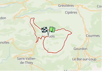
Ruta Carrera de 33 km a descubrir en Provenza-Alpes-Costa Azul, Alpes Marítimos, Caussols. Esta ruta ha sido propuesta por guess.
Descripción
Trail de Caussols le 10 juillet 2016. Parcours du 33 km. Difficile pour la chaleur estivale du mois de juillet dans le Sud. Prévoir un camelbak avec 2L d'eau pour la reco, pas vue de robinet sur le parcours..
Localización
País:
France
Región :
Provenza-Alpes-Costa Azul
Departamento/provincia :
Alpes Marítimos
Municipio :
Caussols
Localidad:
Unknown
Salida:(Dec)
Salida:(UTM)
331004 ; 4845305 (32T) N.
Comentarios
Excursiones cerca
![Excursión Senderismo Caussols - Traversée du Gros Pounch 1270 m, depuis le Col de la Sine - Photo](https://media.geolcdn.com/t/375/260/ext.jpg?maxdim=2&url=https%3A%2F%2Fservices.sitytrail.com%2FGeolivesWS%2FDownloadMedia.ashx%3FTrailID%3D317964%26Media%3D17404_1.jpg)
![Senderismo Senderismo](https://static1.geolcdn.com/sitytour/trail-icons/101.png)
Traversée du Gros Pounch 1270 m, depuis le Col de la Sine
Senderismo
Fácil
(2)
Caussols,
Provenza-Alpes-Costa Azul,
Alpes Marítimos,
France
![](/images/other/stat-length.png)
14,7 km | 19,9 km-effort
4h 15min
![](https://static1.geolcdn.com/siteimages/upload/files/16400158638029165_repeat_loop_refresh_sync_direction_icon.png)
Sí
![Excursión Senderismo Caussols - Le Haut Montet 1335m, Plateau de Caussols - Photo](https://media.geolcdn.com/t/375/260/ext.jpg?maxdim=2&url=https%3A%2F%2Fservices.sitytrail.com%2FGeolivesWS%2FDownloadMedia.ashx%3FTrailID%3D214865%26Media%3D15407_1.jpg)
![Senderismo Senderismo](https://static1.geolcdn.com/sitytour/trail-icons/101.png)
Le Haut Montet 1335m, Plateau de Caussols
Senderismo
Fácil
(1)
Caussols,
Provenza-Alpes-Costa Azul,
Alpes Marítimos,
France
![](/images/other/stat-length.png)
13,5 km | 18,6 km-effort
4h 0min
![](https://static1.geolcdn.com/siteimages/upload/files/16400158638029165_repeat_loop_refresh_sync_direction_icon.png)
Sí
![Excursión Senderismo Andon - Canaux Audibergue Montagne de Thiey depuis Canaux trace réelle - Photo](https://media.geolcdn.com/t/375/260/051e1c19-173e-486c-8510-4484d711db7f.jpg&format=jpg&maxdim=2)
![Senderismo Senderismo](https://static1.geolcdn.com/sitytour/trail-icons/101.png)
Canaux Audibergue Montagne de Thiey depuis Canaux trace réelle
Senderismo
Muy difícil
Andon,
Provenza-Alpes-Costa Azul,
Alpes Marítimos,
France
![](/images/other/stat-length.png)
20 km | 33 km-effort
7h 23min
![](https://static1.geolcdn.com/siteimages/upload/files/16400158638029165_repeat_loop_refresh_sync_direction_icon.png)
Sí
![Excursión Senderismo Cipières - Cipières Sommet de Calern - Grotte de ND de Calern - Photo](https://media.geolcdn.com/t/375/260/dcc22407-202f-49e5-a220-25d384f38a74.jpg&format=jpg&maxdim=2)
![Senderismo Senderismo](https://static1.geolcdn.com/sitytour/trail-icons/101.png)
Cipières Sommet de Calern - Grotte de ND de Calern
Senderismo
Muy difícil
Cipières,
Provenza-Alpes-Costa Azul,
Alpes Marítimos,
France
![](/images/other/stat-length.png)
21 km | 31 km-effort
7h 20min
![](https://static1.geolcdn.com/siteimages/upload/files/16400158638029165_repeat_loop_refresh_sync_direction_icon.png)
No
![Excursión Senderismo Saint-Vallier-de-Thiey - canau - Photo](https://media.geolcdn.com/t/375/260/ca899ab5-eb13-42e5-a84d-3c58455096f9.jpg&format=jpg&maxdim=2)
![Senderismo Senderismo](https://static1.geolcdn.com/sitytour/trail-icons/101.png)
canau
Senderismo
Muy difícil
Saint-Vallier-de-Thiey,
Provenza-Alpes-Costa Azul,
Alpes Marítimos,
France
![](/images/other/stat-length.png)
15,3 km | 23 km-effort
6h 33min
![](https://static1.geolcdn.com/siteimages/upload/files/16400158638029165_repeat_loop_refresh_sync_direction_icon.png)
Sí
![Excursión Senderismo Le Bar-sur-Loup - rando - Photo](https://media.geolcdn.com/t/375/260/fa0ef731-2bd1-40ee-a714-99f05472c6fe.jpg&format=jpg&maxdim=2)
![Senderismo Senderismo](https://static1.geolcdn.com/sitytour/trail-icons/101.png)
rando
Senderismo
Muy difícil
Le Bar-sur-Loup,
Provenza-Alpes-Costa Azul,
Alpes Marítimos,
France
![](/images/other/stat-length.png)
12,1 km | 21 km-effort
6h 9min
![](https://static1.geolcdn.com/siteimages/upload/files/16400158638029165_repeat_loop_refresh_sync_direction_icon.png)
No
![Excursión A pie Caussols - Plateau de Caussols - Photo](https://media.geolcdn.com/t/375/260/598f9742-6bcf-489a-8a9a-6409dd2e2888.jpeg&format=jpg&maxdim=2)
![A pie A pie](https://static1.geolcdn.com/sitytour/trail-icons/100.png)
Plateau de Caussols
A pie
Fácil
Caussols,
Provenza-Alpes-Costa Azul,
Alpes Marítimos,
France
![](/images/other/stat-length.png)
13,9 km | 19,1 km-effort
4h 20min
![](https://static1.geolcdn.com/siteimages/upload/files/16400158638029165_repeat_loop_refresh_sync_direction_icon.png)
Sí
![Excursión A pie Cipières - Traversée de l'Estéron - Etape 2 - Photo](https://media.geolcdn.com/t/375/260/ebd4d990-1504-43f1-96fb-3c8749b403dd.jpeg&format=jpg&maxdim=2)
![A pie A pie](https://static1.geolcdn.com/sitytour/trail-icons/100.png)
Traversée de l'Estéron - Etape 2
A pie
Difícil
Cipières,
Provenza-Alpes-Costa Azul,
Alpes Marítimos,
France
![](/images/other/stat-length.png)
21 km | 41 km-effort
9h 18min
![](https://static1.geolcdn.com/siteimages/upload/files/16400158638029165_repeat_loop_refresh_sync_direction_icon.png)
No
![Excursión A pie Cipières - Traversée de l'Estéron - Etape 1 - Photo](https://media.geolcdn.com/t/375/260/0e49d622-3c08-45d7-a080-59d63fc9110b.jpeg&format=jpg&maxdim=2)
![A pie A pie](https://static1.geolcdn.com/sitytour/trail-icons/100.png)
Traversée de l'Estéron - Etape 1
A pie
Medio
Cipières,
Provenza-Alpes-Costa Azul,
Alpes Marítimos,
France
![](/images/other/stat-length.png)
18,4 km | 29 km-effort
6h 28min
![](https://static1.geolcdn.com/siteimages/upload/files/16400158638029165_repeat_loop_refresh_sync_direction_icon.png)
No