![](/images/other/stat-length.png)
![Excursión Bicicleta Roussillon - Parcours n°27 - Roussillon - Photo](https://media.geolcdn.com/t/1900/400/ext.pjpeg?maxdim=2&url=https%3A%2F%2Fservices.sitytrail.com%2FGeolivesWS%2FDownloadMedia.ashx%3FTrailID%3D583514%26Media%3D3b5a3c66-4682-40be-b8b6-4c9f2f5682f0.jpg)
Parcours n°27 - Roussillon
Vélo Loisir Provence
Randonnées de Vélo Loisir Provence GUIDE+
![Longitud](/images/other/stat-length.png)
![Altitud máxima](https://static1.geolcdn.com/siteimages/upload/files/1508320355ic_sort_altitude_max_24dp.png)
![Desnivel positivo](https://static1.geolcdn.com/siteimages/upload/files/1508320355ic_sort_den_pos_24dp.png)
![Km-Effort](/images/other/stat-length.png)
![Altitud mínima](https://static1.geolcdn.com/siteimages/upload/files/1508320355ic_sort_altitude_min_24dp.png)
![Desnivel negativo](https://static1.geolcdn.com/siteimages/upload/files/1508320355ic_sort_den_neg_24dp.png)
![Boucle](https://static1.geolcdn.com/siteimages/upload/files/16400158638029165_repeat_loop_refresh_sync_direction_icon.png)
![Bicicleta](https://static1.geolcdn.com/sitytour/trail-icons/200.png)
1h31
Dificultad : Fácil
![Escanee este código QR para abrir la excursión en la aplicación SityTrail](https://capi.geolives.com/qq0zvz2zws4bq2lad0pu/sitytour/trails/583514/qr.png?size=200)
Aplicación GPS de excursión GRATIS
A propósito
Ruta Bicicleta de 22 km a descubrir en Provenza-Alpes-Costa Azul, Vaucluse, Roussillon. Esta ruta ha sido propuesta por Vélo Loisir Provence.
Descripción
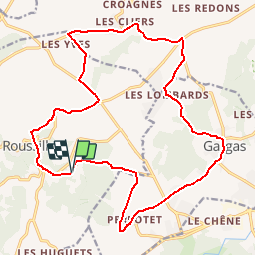
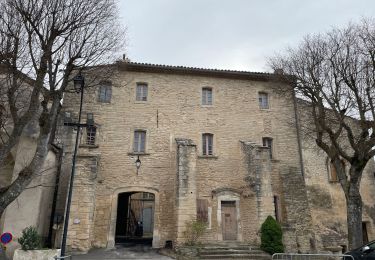
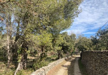
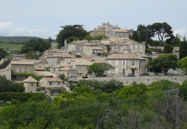
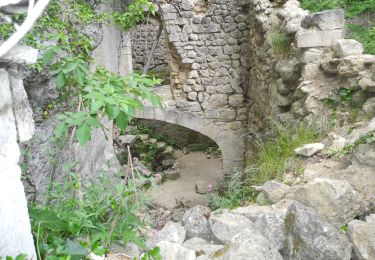
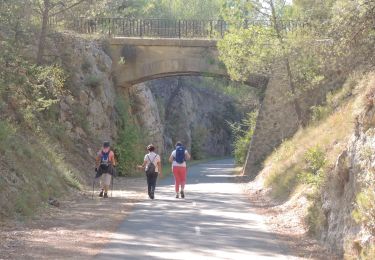
Ochre by bike: 1 route to explore from Roussillon ! The visit to the ancient ochre mills is a fantastic insight into the skills of color creation, with guided visits, work-shop courses, a bookshop and a boutique. From Okhra, take part and explore 1 totally original itinerary, accessible to the whole family (from 12 years old, itinerary of 20 km -12.5 miles each). Experience both the industrial and the human imprints which have made their impact over the centuries. Direction of the itinerary : Roussillon (Okhra) <-> La Tuillère <-> Gargas <-> Le Perrotet <-> Roussillon (Okhra)
Localización
Comentarios
Excursiones cerca
![Bici de montaña Bici de montaña](https://static1.geolcdn.com/sitytour/trail-icons/202.png)
Bici de montaña
![](/images/other/stat-length.png)
![](https://static1.geolcdn.com/siteimages/upload/files/16400158638029165_repeat_loop_refresh_sync_direction_icon.png)
![Excursión Senderismo Joucas - Gorges de Véroncle Via Joucas - Photo](https://media.geolcdn.com/t/375/260/d22eb38c-13a7-4d92-b40f-aa814b45ca9c.jpg&format=jpg&maxdim=2)
![Senderismo Senderismo](https://static1.geolcdn.com/sitytour/trail-icons/101.png)
Senderismo
![](/images/other/stat-length.png)
![](https://static1.geolcdn.com/siteimages/upload/files/16400158638029165_repeat_loop_refresh_sync_direction_icon.png)
![Excursión Senderismo Goult - PF-Goult - Beaumettes - Lumières - 15.03.2022 - Photo](https://media.geolcdn.com/t/375/260/4c927e97-dbf8-4901-ab27-568f32baec87.jpg&format=jpg&maxdim=2)
![Senderismo Senderismo](https://static1.geolcdn.com/sitytour/trail-icons/101.png)
Senderismo
![](/images/other/stat-length.png)
![](https://static1.geolcdn.com/siteimages/upload/files/16400158638029165_repeat_loop_refresh_sync_direction_icon.png)
![Senderismo Senderismo](https://static1.geolcdn.com/sitytour/trail-icons/101.png)
Senderismo
![](/images/other/stat-length.png)
![](https://static1.geolcdn.com/siteimages/upload/files/16400158638029165_repeat_loop_refresh_sync_direction_icon.png)
![Excursión Senderismo Joucas - Joucas murs - Photo](https://media.geolcdn.com/t/375/260/c0d3985a-a517-4f68-8bd1-27327696ed65.jpg&format=jpg&maxdim=2)
![Senderismo Senderismo](https://static1.geolcdn.com/sitytour/trail-icons/101.png)
Senderismo
![](/images/other/stat-length.png)
![](https://static1.geolcdn.com/siteimages/upload/files/16400158638029165_repeat_loop_refresh_sync_direction_icon.png)
![Excursión Senderismo Joucas - Joucas - Les gorges de Véroncle - Photo](https://media.geolcdn.com/t/375/260/4e42391b-0fdf-40e9-868c-987cf47fc93d.jpg&format=jpg&maxdim=2)
![Senderismo Senderismo](https://static1.geolcdn.com/sitytour/trail-icons/101.png)
Senderismo
![](/images/other/stat-length.png)
![](https://static1.geolcdn.com/siteimages/upload/files/16400158638029165_repeat_loop_refresh_sync_direction_icon.png)
![Senderismo Senderismo](https://static1.geolcdn.com/sitytour/trail-icons/101.png)
Senderismo
![](/images/other/stat-length.png)
![](https://static1.geolcdn.com/siteimages/upload/files/16400158638029165_repeat_loop_refresh_sync_direction_icon.png)
![Senderismo Senderismo](https://static1.geolcdn.com/sitytour/trail-icons/101.png)
Senderismo
![](/images/other/stat-length.png)
![](https://static1.geolcdn.com/siteimages/upload/files/16400158638029165_repeat_loop_refresh_sync_direction_icon.png)
![Senderismo Senderismo](https://static1.geolcdn.com/sitytour/trail-icons/101.png)
Senderismo
![](/images/other/stat-length.png)
![](https://static1.geolcdn.com/siteimages/upload/files/16400158638029165_repeat_loop_refresh_sync_direction_icon.png)