


 les Mas, piste DFCI AL12, les Paraguères, Casot del Guarda, font de la Vernosa, chapelle St fructueux de Roca Vella, Itin.9 R - Photo 21")
 les Mas, piste DFCI AL12, les Paraguères, Casot del Guarda, font de la Vernosa, chapelle St fructueux de Roca Vella, Itin.9 R - Photo 22")
 les Mas, piste DFCI AL12, les Paraguères, Casot del Guarda, font de la Vernosa, chapelle St fructueux de Roca Vella, Itin.9 R - Photo 23")
 les Mas, piste DFCI AL12, les Paraguères, Casot del Guarda, font de la Vernosa, chapelle St fructueux de Roca Vella, Itin.9 R - Photo 24")

5,4 km | 7,1 km-effort


Usuario


Aplicación GPS de excursión GRATIS
 SityTrail
IGN / Institutos geográficos
SityTrail World
El mundo es suyo
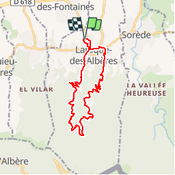
Ruta Senderismo de 15,7 km a descubrir en Occitania, Pirineos Orientales, Laroque-des-Albères. Esta ruta ha sido propuesta por jeff66.
66 LAROQUE DES ALBERES, (maison) rue de La Chapelle, av. du Roussillon, rues des écoles-JS PONS- de Sorède- Portal- de la montagne, mas Manera, mas sors, mas blanc mas Malzac, piste DFCI AL12, vue sur sorède argeles la plaine la côte les corbières, mas Christi, les Paraguères, Correc de les Teixoneres, les Borrasseres, Ribera de la Roca, Casot del Guarda, Correc du col de L' ouillat, font de la Vernosa, Correc de la Jaça, chapelle Saint fructueux, Mas PEYRE, ch, de la Roca vella, itin.9
 les Mas, piste DFCI AL12, les Paraguères, Casot del Guarda, font de la Vernosa, chapelle St fructueux de Roca Vella, Itin.9 R - Photo 1")
 les Mas, piste DFCI AL12, les Paraguères, Casot del Guarda, font de la Vernosa, chapelle St fructueux de Roca Vella, Itin.9 R - Photo 2")
 les Mas, piste DFCI AL12, les Paraguères, Casot del Guarda, font de la Vernosa, chapelle St fructueux de Roca Vella, Itin.9 R - Photo 3")
 les Mas, piste DFCI AL12, les Paraguères, Casot del Guarda, font de la Vernosa, chapelle St fructueux de Roca Vella, Itin.9 R - Photo 4")
 les Mas, piste DFCI AL12, les Paraguères, Casot del Guarda, font de la Vernosa, chapelle St fructueux de Roca Vella, Itin.9 R - Photo 5")
 les Mas, piste DFCI AL12, les Paraguères, Casot del Guarda, font de la Vernosa, chapelle St fructueux de Roca Vella, Itin.9 R - Photo 6")
 les Mas, piste DFCI AL12, les Paraguères, Casot del Guarda, font de la Vernosa, chapelle St fructueux de Roca Vella, Itin.9 R - Photo 7")
 les Mas, piste DFCI AL12, les Paraguères, Casot del Guarda, font de la Vernosa, chapelle St fructueux de Roca Vella, Itin.9 R - Photo 8")
 les Mas, piste DFCI AL12, les Paraguères, Casot del Guarda, font de la Vernosa, chapelle St fructueux de Roca Vella, Itin.9 R - Photo 9")
 les Mas, piste DFCI AL12, les Paraguères, Casot del Guarda, font de la Vernosa, chapelle St fructueux de Roca Vella, Itin.9 R - Photo 10")
 les Mas, piste DFCI AL12, les Paraguères, Casot del Guarda, font de la Vernosa, chapelle St fructueux de Roca Vella, Itin.9 R - Photo 11")
 les Mas, piste DFCI AL12, les Paraguères, Casot del Guarda, font de la Vernosa, chapelle St fructueux de Roca Vella, Itin.9 R - Photo 12")
 les Mas, piste DFCI AL12, les Paraguères, Casot del Guarda, font de la Vernosa, chapelle St fructueux de Roca Vella, Itin.9 R - Photo 13")
 les Mas, piste DFCI AL12, les Paraguères, Casot del Guarda, font de la Vernosa, chapelle St fructueux de Roca Vella, Itin.9 R - Photo 14")
 les Mas, piste DFCI AL12, les Paraguères, Casot del Guarda, font de la Vernosa, chapelle St fructueux de Roca Vella, Itin.9 R - Photo 15")
 les Mas, piste DFCI AL12, les Paraguères, Casot del Guarda, font de la Vernosa, chapelle St fructueux de Roca Vella, Itin.9 R - Photo 16")
 les Mas, piste DFCI AL12, les Paraguères, Casot del Guarda, font de la Vernosa, chapelle St fructueux de Roca Vella, Itin.9 R - Photo 17")
 les Mas, piste DFCI AL12, les Paraguères, Casot del Guarda, font de la Vernosa, chapelle St fructueux de Roca Vella, Itin.9 R - Photo 18")
 les Mas, piste DFCI AL12, les Paraguères, Casot del Guarda, font de la Vernosa, chapelle St fructueux de Roca Vella, Itin.9 R - Photo 19")
 les Mas, piste DFCI AL12, les Paraguères, Casot del Guarda, font de la Vernosa, chapelle St fructueux de Roca Vella, Itin.9 R - Photo 20")
24 fotos en total. Haga clic en una foto para mostrarlas todas en la galería.

Senderismo

Senderismo

Senderismo

Senderismo

Senderismo

Senderismo

Senderismo

Senderismo

Senderismo