![](/images/other/stat-length.png)
![Excursión Senderismo Bernac - Bernac - Photo](https://media.geolcdn.com/t/1900/400/ext.pjpeg?maxdim=2&url=https%3A%2F%2Fstatic1.geolcdn.com%2Fsiteimages%2Fupload%2Ffiles%2F1553511878bg_sport_marche.png)
Bernac
neoroll44
Usuario
![Longitud](/images/other/stat-length.png)
Longitud
12,6 km
![Altitud máxima](https://static1.geolcdn.com/siteimages/upload/files/1508320355ic_sort_altitude_max_24dp.png)
Altitud máxima
137 m
![Desnivel positivo](https://static1.geolcdn.com/siteimages/upload/files/1508320355ic_sort_den_pos_24dp.png)
Desnivel positivo
150 m
![Km-Effort](/images/other/stat-length.png)
Km-Effort
14,6 km
![Altitud mínima](https://static1.geolcdn.com/siteimages/upload/files/1508320355ic_sort_altitude_min_24dp.png)
Altitud mínima
96 m
![Desnivel negativo](https://static1.geolcdn.com/siteimages/upload/files/1508320355ic_sort_den_neg_24dp.png)
Desnivel negativo
149 m
![Boucle](https://static1.geolcdn.com/siteimages/upload/files/16400158638029165_repeat_loop_refresh_sync_direction_icon.png)
Boucle
Sí
Fecha de creación :
2016-04-20 00:00:00.0
Última modificación :
2016-04-20 00:00:00.0
![Senderismo](https://static1.geolcdn.com/sitytour/trail-icons/101.png)
3h20
Dificultad : Fácil
![Escanee este código QR para abrir la excursión en la aplicación SityTrail](https://capi.geolives.com/qq0zvz2zws4bq2lad0pu/sitytour/trails/556598/qr.png?size=200)
Aplicación GPS de excursión GRATIS
A propósito
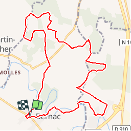
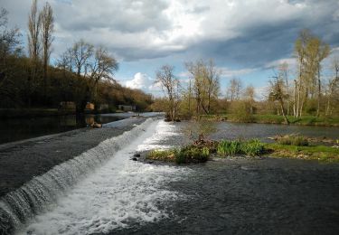
Ruta Senderismo de 12,6 km a descubrir en Nueva Aquitania, Charente, Bernac. Esta ruta ha sido propuesta por neoroll44.
Descripción
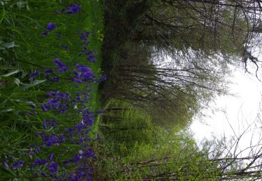
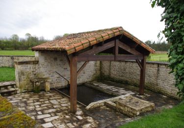
Circuit de la Font du Maçon (vert). Départ du parking du cimetière. Vers la Paizière, le bois des Jarris et le logis des Nouzières.
Localización
País:
France
Región :
Nueva Aquitania
Departamento/provincia :
Charente
Municipio :
Bernac
Localidad:
Unknown
Salida:(Dec)
Salida:(UTM)
280814 ; 5102862 (31T) N.
Comentarios
Excursiones cerca
![Excursión Bicicleta híbrida Condac - rejellant chassane - Photo](https://media.geolcdn.com/t/375/260/f941dbf9-6f50-4e7d-8c40-12817a339d98.jpg&format=jpg&maxdim=2)
![Bicicleta híbrida Bicicleta híbrida](https://static1.geolcdn.com/sitytour/trail-icons/203.png)
rejellant chassane
Bicicleta híbrida
Fácil
Condac,
Nueva Aquitania,
Charente,
France
![](/images/other/stat-length.png)
17,5 km | 19,6 km-effort
5h 11min
![](https://static1.geolcdn.com/siteimages/upload/files/16400158638029165_repeat_loop_refresh_sync_direction_icon.png)
No
![Excursión Senderismo Ruffec - Ruffec_Logis - Photo](https://media.geolcdn.com/t/375/260/ext.jpg?maxdim=2&url=https%3A%2F%2Fservices.sitytrail.com%2FGeolivesWS%2FDownloadMedia.ashx%3FTrailID%3D556592%26Media%3D8a704e77-b4ef-4ee8-815d-c58a809173e3.JPG)
![Senderismo Senderismo](https://static1.geolcdn.com/sitytour/trail-icons/101.png)
Ruffec_Logis
Senderismo
Medio
Ruffec,
Nueva Aquitania,
Charente,
France
![](/images/other/stat-length.png)
17,3 km | 19,7 km-effort
4h 20min
![](https://static1.geolcdn.com/siteimages/upload/files/16400158638029165_repeat_loop_refresh_sync_direction_icon.png)
Sí
![Excursión Senderismo Condac - Condac - Photo](https://media.geolcdn.com/t/375/260/ext.jpg?maxdim=2&url=https%3A%2F%2Fservices.sitytrail.com%2FGeolivesWS%2FDownloadMedia.ashx%3FTrailID%3D556317%26Media%3Ddcadb249-373c-4f07-b689-15b2cfca5ca5.JPG)
![Senderismo Senderismo](https://static1.geolcdn.com/sitytour/trail-icons/101.png)
Condac
Senderismo
Medio
Condac,
Nueva Aquitania,
Charente,
France
![](/images/other/stat-length.png)
11,2 km | 13,1 km-effort
3h 0min
![](https://static1.geolcdn.com/siteimages/upload/files/16400158638029165_repeat_loop_refresh_sync_direction_icon.png)
Sí
![Excursión Senderismo Ruffec - Ruffec_Forêt - Photo](https://media.geolcdn.com/t/375/260/ext.jpg?maxdim=2&url=https%3A%2F%2Fservices.sitytrail.com%2FGeolivesWS%2FDownloadMedia.ashx%3FTrailID%3D554305%26Media%3D4db66742-d552-44a5-85d9-ad956cf37102.JPG)
![Senderismo Senderismo](https://static1.geolcdn.com/sitytour/trail-icons/101.png)
Ruffec_Forêt
Senderismo
Fácil
Ruffec,
Nueva Aquitania,
Charente,
France
![](/images/other/stat-length.png)
8,5 km | 10 km-effort
2h 20min
![](https://static1.geolcdn.com/siteimages/upload/files/16400158638029165_repeat_loop_refresh_sync_direction_icon.png)
Sí
![Excursión Senderismo Condac - Condac_Bioussac_Barro - Photo](https://media.geolcdn.com/t/375/260/ext.jpg?maxdim=2&url=https%3A%2F%2Fservices.sitytrail.com%2FGeolivesWS%2FDownloadMedia.ashx%3FTrailID%3D554281%26Media%3Dad2440e1-83f4-4ca4-9ca5-3c359047fce4.JPG)
![Senderismo Senderismo](https://static1.geolcdn.com/sitytour/trail-icons/101.png)
Condac_Bioussac_Barro
Senderismo
Medio
Condac,
Nueva Aquitania,
Charente,
France
![](/images/other/stat-length.png)
26 km | 31 km-effort
6h 40min
![](https://static1.geolcdn.com/siteimages/upload/files/16400158638029165_repeat_loop_refresh_sync_direction_icon.png)
Sí
![Excursión Senderismo Ruffec - Ruffec_Jardins - Photo](https://media.geolcdn.com/t/375/260/ext.jpg?maxdim=2&url=https%3A%2F%2Fservices.sitytrail.com%2FGeolivesWS%2FDownloadMedia.ashx%3FTrailID%3D555645%26Media%3Da0f43bbb-0193-406e-8ccd-743115a33ead.jpg)
![Senderismo Senderismo](https://static1.geolcdn.com/sitytour/trail-icons/101.png)
Ruffec_Jardins
Senderismo
Fácil
(2)
Ruffec,
Nueva Aquitania,
Charente,
France
![](/images/other/stat-length.png)
5,4 km | 6,2 km-effort
1h 30min
![](https://static1.geolcdn.com/siteimages/upload/files/16400158638029165_repeat_loop_refresh_sync_direction_icon.png)
Sí
![Excursión Senderismo Les Adjots - Les Adjots - Photo](https://media.geolcdn.com/t/375/260/ext.jpg?maxdim=2&url=https%3A%2F%2Fstatic1.geolcdn.com%2Fsiteimages%2Fupload%2Ffiles%2F1553511878bg_sport_marche.png)
![Senderismo Senderismo](https://static1.geolcdn.com/sitytour/trail-icons/101.png)
Les Adjots
Senderismo
Medio
Les Adjots,
Nueva Aquitania,
Charente,
France
![](/images/other/stat-length.png)
17,5 km | 19,7 km-effort
4h 20min
![](https://static1.geolcdn.com/siteimages/upload/files/16400158638029165_repeat_loop_refresh_sync_direction_icon.png)
Sí
![Excursión Senderismo La Faye - La Faye - Photo](https://media.geolcdn.com/t/375/260/ext.jpg?maxdim=2&url=https%3A%2F%2Fstatic1.geolcdn.com%2Fsiteimages%2Fupload%2Ffiles%2F1553511878bg_sport_marche.png)
![Senderismo Senderismo](https://static1.geolcdn.com/sitytour/trail-icons/101.png)
La Faye
Senderismo
Fácil
La Faye,
Nueva Aquitania,
Charente,
France
![](/images/other/stat-length.png)
9 km | 10,1 km-effort
2h 20min
![](https://static1.geolcdn.com/siteimages/upload/files/16400158638029165_repeat_loop_refresh_sync_direction_icon.png)
Sí