![](/images/other/stat-length.png)
![Excursión Senderismo Bléneau - Rando des étangs - Photo](https://media.geolcdn.com/t/1900/400/ext.pjpeg?maxdim=2&url=https%3A%2F%2Fservices.sitytrail.com%2FGeolivesWS%2FDownloadMedia.ashx%3FTrailID%3D554786%26Media%3Da2e3824b-b349-4ee7-8bea-587a83e0623e.jpg)
Rando des étangs
Ordijamo45
Usuario
![Longitud](/images/other/stat-length.png)
Longitud
16 km
![Altitud máxima](https://static1.geolcdn.com/siteimages/upload/files/1508320355ic_sort_altitude_max_24dp.png)
Altitud máxima
203 m
![Desnivel positivo](https://static1.geolcdn.com/siteimages/upload/files/1508320355ic_sort_den_pos_24dp.png)
Desnivel positivo
121 m
![Km-Effort](/images/other/stat-length.png)
Km-Effort
17,6 km
![Altitud mínima](https://static1.geolcdn.com/siteimages/upload/files/1508320355ic_sort_altitude_min_24dp.png)
Altitud mínima
172 m
![Desnivel negativo](https://static1.geolcdn.com/siteimages/upload/files/1508320355ic_sort_den_neg_24dp.png)
Desnivel negativo
120 m
![Boucle](https://static1.geolcdn.com/siteimages/upload/files/16400158638029165_repeat_loop_refresh_sync_direction_icon.png)
Boucle
Sí
Fecha de creación :
2019-05-03 09:15:11.991
Última modificación :
2019-05-03 09:15:12.181
![Senderismo](https://static1.geolcdn.com/sitytour/trail-icons/101.png)
3h00
Dificultad : Fácil
![Escanee este código QR para abrir la excursión en la aplicación SityTrail](https://capi.geolives.com/qq0zvz2zws4bq2lad0pu/sitytour/trails/554786/qr.png?size=200)
Aplicación GPS de excursión GRATIS
A propósito
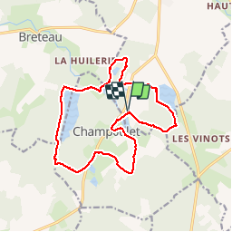
Ruta Senderismo de 16 km a descubrir en Borgoña-Franco Condado, Yonne, Bléneau. Esta ruta ha sido propuesta por Ordijamo45.
Descripción
Départ de l'étang de la Cahauderie (a patir de Bléneau(89) prendre la direction Bonny-sur-Loire)
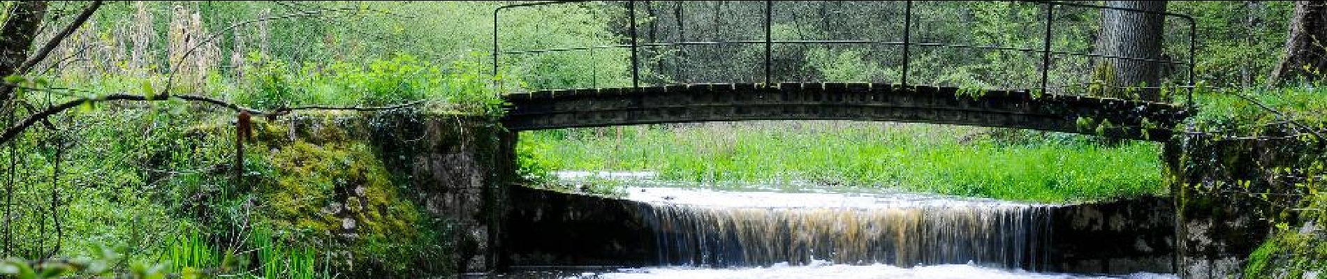
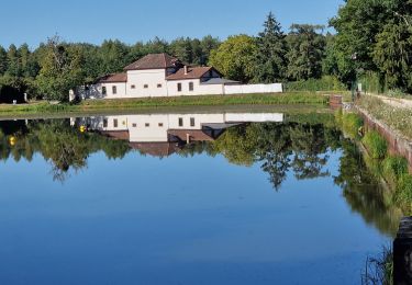
Trés belle randonnée mais Chemins un peu difficile surtout vers la fin du aux fortes pluies dans la nuit
Localización
País:
France
Región :
Borgoña-Franco Condado
Departamento/provincia :
Yonne
Municipio :
Bléneau
Localidad:
Unknown
Salida:(Dec)
Salida:(UTM)
494519 ; 5278881 (31T) N.
Comentarios
Excursiones cerca
![Excursión Senderismo Breteau - tour de la Garenne de Reuilly en Puisaye - Photo](https://media.geolcdn.com/t/375/260/ext.jpg?maxdim=2&url=https%3A%2F%2Fservices.sitytrail.com%2FGeolivesWS%2FDownloadMedia.ashx%3FTrailID%3D564126%26Media%3D20160505162427.jpg)
![Senderismo Senderismo](https://static1.geolcdn.com/sitytour/trail-icons/101.png)
tour de la Garenne de Reuilly en Puisaye
Senderismo
Muy fácil
Breteau,
Centro,
Loiret,
France
![](/images/other/stat-length.png)
5,3 km | 5,9 km-effort
1h 32min
![](https://static1.geolcdn.com/siteimages/upload/files/16400158638029165_repeat_loop_refresh_sync_direction_icon.png)
Sí
![Excursión Senderismo Bléneau - Bleneaux 89 - Photo](https://media.geolcdn.com/t/375/260/8b61be8a-a7e2-4406-b600-f0e7123121b4.jpg&format=jpg&maxdim=2)
![Senderismo Senderismo](https://static1.geolcdn.com/sitytour/trail-icons/101.png)
Bleneaux 89
Senderismo
Fácil
Bléneau,
Borgoña-Franco Condado,
Yonne,
France
![](/images/other/stat-length.png)
9,6 km | 10,6 km-effort
3h 15min
![](https://static1.geolcdn.com/siteimages/upload/files/16400158638029165_repeat_loop_refresh_sync_direction_icon.png)
Sí
![Excursión Senderismo Champoulet - Champoulet (les étangs) - Photo](https://media.geolcdn.com/t/375/260/ext.jpg?maxdim=2&url=https%3A%2F%2Fstatic1.geolcdn.com%2Fsiteimages%2Fupload%2Ffiles%2F1553511878bg_sport_marche.png)
![Senderismo Senderismo](https://static1.geolcdn.com/sitytour/trail-icons/101.png)
Champoulet (les étangs)
Senderismo
Muy fácil
Champoulet,
Centro,
Loiret,
France
![](/images/other/stat-length.png)
9,4 km | 10,3 km-effort
2h 20min
![](https://static1.geolcdn.com/siteimages/upload/files/16400158638029165_repeat_loop_refresh_sync_direction_icon.png)
Sí
![Excursión Senderismo Champoulet - Champoulet - Photo](https://media.geolcdn.com/t/375/260/ext.jpg?maxdim=2&url=https%3A%2F%2Fstatic1.geolcdn.com%2Fsiteimages%2Fupload%2Ffiles%2F1553511878bg_sport_marche.png)
![Senderismo Senderismo](https://static1.geolcdn.com/sitytour/trail-icons/101.png)
![Excursión Senderismo Champoulet - Autour des étangs de Champoulet - Photo](https://media.geolcdn.com/t/375/260/ext.jpg?maxdim=2&url=https%3A%2F%2Fstatic1.geolcdn.com%2Fsiteimages%2Fupload%2Ffiles%2F1553511878bg_sport_marche.png)
![Senderismo Senderismo](https://static1.geolcdn.com/sitytour/trail-icons/101.png)
Autour des étangs de Champoulet
Senderismo
Muy fácil
Champoulet,
Centro,
Loiret,
France
![](/images/other/stat-length.png)
10,7 km | 11,9 km-effort
2h 38min
![](https://static1.geolcdn.com/siteimages/upload/files/16400158638029165_repeat_loop_refresh_sync_direction_icon.png)
Sí
![Excursión Caballo Saint-Privé - Géro.Etape5 - Photo](https://media.geolcdn.com/t/375/260/ext.jpg?maxdim=2&url=https%3A%2F%2Fstatic1.geolcdn.com%2Fsiteimages%2Fupload%2Ffiles%2F1524743154cheval.jpg)
![Caballo Caballo](https://static1.geolcdn.com/sitytour/trail-icons/300.png)
Géro.Etape5
Caballo
Muy fácil
Saint-Privé,
Borgoña-Franco Condado,
Yonne,
France
![](/images/other/stat-length.png)
34 km | 37 km-effort
5h 0min
![](https://static1.geolcdn.com/siteimages/upload/files/16400158638029165_repeat_loop_refresh_sync_direction_icon.png)
No
![Excursión Senderismo Bléneau - Rando des étangs (2017) - Photo](https://media.geolcdn.com/t/375/260/ext.jpg?maxdim=2&url=https%3A%2F%2Fstatic1.geolcdn.com%2Fsiteimages%2Fupload%2Ffiles%2F1553511878bg_sport_marche.png)
![Senderismo Senderismo](https://static1.geolcdn.com/sitytour/trail-icons/101.png)
Rando des étangs (2017)
Senderismo
Fácil
Bléneau,
Borgoña-Franco Condado,
Yonne,
France
![](/images/other/stat-length.png)
15,8 km | 17,3 km-effort
3h 16min
![](https://static1.geolcdn.com/siteimages/upload/files/16400158638029165_repeat_loop_refresh_sync_direction_icon.png)
Sí
![Excursión Senderismo Breteau - De digues en digues à Champoulet - Photo](https://media.geolcdn.com/t/375/260/ext.jpg?maxdim=2&url=https%3A%2F%2Fstatic1.geolcdn.com%2Fsiteimages%2Fupload%2Ffiles%2F1553511878bg_sport_marche.png)
![Senderismo Senderismo](https://static1.geolcdn.com/sitytour/trail-icons/101.png)
De digues en digues à Champoulet
Senderismo
Fácil
Breteau,
Centro,
Loiret,
France
![](/images/other/stat-length.png)
15,5 km | 17,1 km-effort
3h 46min
![](https://static1.geolcdn.com/siteimages/upload/files/16400158638029165_repeat_loop_refresh_sync_direction_icon.png)
Sí
![Excursión Senderismo Bléneau - Bleneau 89 Nicole - Photo](https://media.geolcdn.com/t/375/260/ext.jpg?maxdim=2&url=https%3A%2F%2Fstatic1.geolcdn.com%2Fsiteimages%2Fupload%2Ffiles%2F1553511878bg_sport_marche.png)
![Senderismo Senderismo](https://static1.geolcdn.com/sitytour/trail-icons/101.png)
Bleneau 89 Nicole
Senderismo
Medio
Bléneau,
Borgoña-Franco Condado,
Yonne,
France
![](/images/other/stat-length.png)
9,5 km | 10,5 km-effort
2h 23min
![](https://static1.geolcdn.com/siteimages/upload/files/16400158638029165_repeat_loop_refresh_sync_direction_icon.png)
No