![](/images/other/stat-length.png)
![Excursión Senderismo Le Tholy - Roches de la Moulure - Photo](https://media.geolcdn.com/t/1900/400/ext.pjpeg?maxdim=2&url=https%3A%2F%2Fstatic1.geolcdn.com%2Fsiteimages%2Fupload%2Ffiles%2F1553511878bg_sport_marche.png)
Roches de la Moulure
jeanclaude12
Usuario
![Longitud](/images/other/stat-length.png)
Longitud
13,9 km
![Altitud máxima](https://static1.geolcdn.com/siteimages/upload/files/1508320355ic_sort_altitude_max_24dp.png)
Altitud máxima
798 m
![Desnivel positivo](https://static1.geolcdn.com/siteimages/upload/files/1508320355ic_sort_den_pos_24dp.png)
Desnivel positivo
286 m
![Km-Effort](/images/other/stat-length.png)
Km-Effort
17,7 km
![Altitud mínima](https://static1.geolcdn.com/siteimages/upload/files/1508320355ic_sort_altitude_min_24dp.png)
Altitud mínima
611 m
![Desnivel negativo](https://static1.geolcdn.com/siteimages/upload/files/1508320355ic_sort_den_neg_24dp.png)
Desnivel negativo
286 m
![Boucle](https://static1.geolcdn.com/siteimages/upload/files/16400158638029165_repeat_loop_refresh_sync_direction_icon.png)
Boucle
Sí
Fecha de creación :
2016-04-15 00:00:00.0
Última modificación :
2016-04-15 00:00:00.0
![Senderismo](https://static1.geolcdn.com/sitytour/trail-icons/101.png)
4h13
Dificultad : Fácil
![Escanee este código QR para abrir la excursión en la aplicación SityTrail](https://capi.geolives.com/qq0zvz2zws4bq2lad0pu/sitytour/trails/554134/qr.png?size=200)
Aplicación GPS de excursión GRATIS
A propósito
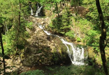
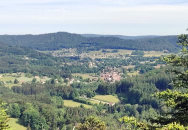
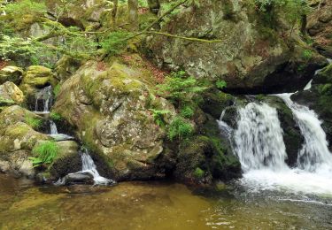
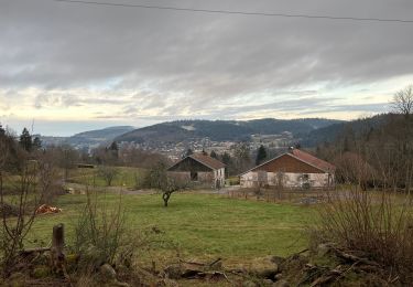
Ruta Senderismo de 13,9 km a descubrir en Gran Este, Vosgos, Le Tholy. Esta ruta ha sido propuesta por jeanclaude12.
Descripción
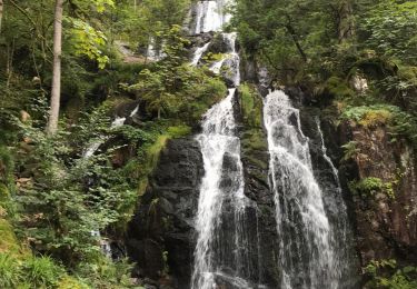
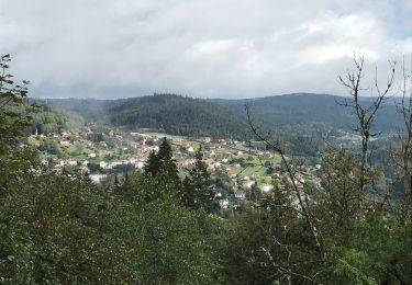
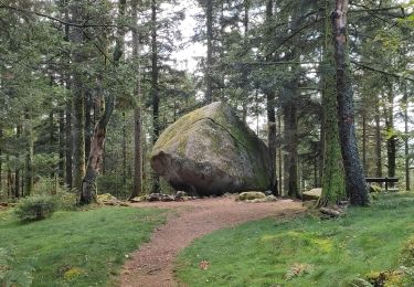
Au départ proche du Col de Bonne Fontaine, voilà une belle randonnée autour du Bois de la Charme de l'Ormont, à faire au cours d'une après-midi ensoleillée.
Localización
País:
France
Región :
Gran Este
Departamento/provincia :
Vosgos
Municipio :
Le Tholy
Localidad:
Unknown
Salida:(Dec)
Salida:(UTM)
330753 ; 5329789 (32U) N.
Comentarios
Excursiones cerca
![Excursión Senderismo Tendon - Cascades de Tendon - Trou de l'Enfer - Roches de la Moulure - Photo](https://media.geolcdn.com/t/375/260/6cb30f79-01f0-4a87-b35f-5f5af3475353.jpg&format=jpg&maxdim=2)
![Senderismo Senderismo](https://static1.geolcdn.com/sitytour/trail-icons/101.png)
Cascades de Tendon - Trou de l'Enfer - Roches de la Moulure
Senderismo
Medio
(4)
Tendon,
Gran Este,
Vosgos,
France
![](/images/other/stat-length.png)
20 km | 28 km-effort
5h 33min
![](https://static1.geolcdn.com/siteimages/upload/files/16400158638029165_repeat_loop_refresh_sync_direction_icon.png)
Sí
![Paseo ecuestre Paseo ecuestre](https://static1.geolcdn.com/sitytour/trail-icons/301.png)
2022-06-03 Rando CVA Le Tholy Gerbamont
Paseo ecuestre
Muy difícil
Le Tholy,
Gran Este,
Vosgos,
France
![](/images/other/stat-length.png)
28 km | 41 km-effort
6h 25min
![](https://static1.geolcdn.com/siteimages/upload/files/16400158638029165_repeat_loop_refresh_sync_direction_icon.png)
No
![Excursión Paseo ecuestre Le Tholy - 2022-06-02 Rando CVA Le Tholy Tête des Cuveaux - Photo](https://media.geolcdn.com/t/375/260/655700ee-4545-4284-b9be-e2f2446a936f.jpg&format=jpg&maxdim=2)
![Paseo ecuestre Paseo ecuestre](https://static1.geolcdn.com/sitytour/trail-icons/301.png)
2022-06-02 Rando CVA Le Tholy Tête des Cuveaux
Paseo ecuestre
Difícil
Le Tholy,
Gran Este,
Vosgos,
France
![](/images/other/stat-length.png)
28 km | 40 km-effort
5h 19min
![](https://static1.geolcdn.com/siteimages/upload/files/16400158638029165_repeat_loop_refresh_sync_direction_icon.png)
Sí
![Paseo ecuestre Paseo ecuestre](https://static1.geolcdn.com/sitytour/trail-icons/301.png)
2022-06-01 Rando CVA Le Tholy Boucle Cascades du Tendon
Paseo ecuestre
Difícil
Le Tholy,
Gran Este,
Vosgos,
France
![](/images/other/stat-length.png)
24 km | 34 km-effort
5h 16min
![](https://static1.geolcdn.com/siteimages/upload/files/16400158638029165_repeat_loop_refresh_sync_direction_icon.png)
Sí
![Excursión Senderismo Le Tholy - tendon - Photo](https://media.geolcdn.com/t/375/260/ext.jpg?maxdim=2&url=https%3A%2F%2Fstatic1.geolcdn.com%2Fsiteimages%2Fupload%2Ffiles%2F1553511878bg_sport_marche.png)
![Senderismo Senderismo](https://static1.geolcdn.com/sitytour/trail-icons/101.png)
![Excursión Senderismo Le Tholy - Sentier de la Roche Au Blaireau depuis le gîte - Photo](https://media.geolcdn.com/t/375/260/953f411c-aa19-4208-97f3-48d7a7911f9d.jpg&format=jpg&maxdim=2)
![Senderismo Senderismo](https://static1.geolcdn.com/sitytour/trail-icons/101.png)
Sentier de la Roche Au Blaireau depuis le gîte
Senderismo
Medio
Le Tholy,
Gran Este,
Vosgos,
France
![](/images/other/stat-length.png)
4,4 km | 6,5 km-effort
1h 25min
![](https://static1.geolcdn.com/siteimages/upload/files/16400158638029165_repeat_loop_refresh_sync_direction_icon.png)
Sí
![Excursión Senderismo Le Tholy - La grande cascade du Tendon au départ du Grand Caillou. - Photo](https://media.geolcdn.com/t/375/260/29f756ea-f122-4fe5-a807-1bae772526aa.jpg&format=jpg&maxdim=2)
![Senderismo Senderismo](https://static1.geolcdn.com/sitytour/trail-icons/101.png)
La grande cascade du Tendon au départ du Grand Caillou.
Senderismo
Difícil
Le Tholy,
Gran Este,
Vosgos,
France
![](/images/other/stat-length.png)
9 km | 12,2 km-effort
2h 46min
![](https://static1.geolcdn.com/siteimages/upload/files/16400158638029165_repeat_loop_refresh_sync_direction_icon.png)
Sí
![Excursión Senderismo La Forge - La roche des corbeaux, La Forge - Photo](https://media.geolcdn.com/t/375/260/130216fa-767d-4902-bf97-0a8dff8eb2b3.jpg&format=jpg&maxdim=2)
![Senderismo Senderismo](https://static1.geolcdn.com/sitytour/trail-icons/101.png)
La roche des corbeaux, La Forge
Senderismo
Medio
La Forge,
Gran Este,
Vosgos,
France
![](/images/other/stat-length.png)
7,8 km | 11,2 km-effort
2h 33min
![](https://static1.geolcdn.com/siteimages/upload/files/16400158638029165_repeat_loop_refresh_sync_direction_icon.png)
Sí
![Excursión Senderismo Le Tholy - Le trou de l'enfer - Photo](https://media.geolcdn.com/t/375/260/b8b0e984-8b12-439a-8fed-764b95b3aaa2.jpg&format=jpg&maxdim=2)
![Senderismo Senderismo](https://static1.geolcdn.com/sitytour/trail-icons/101.png)
Le trou de l'enfer
Senderismo
Medio
Le Tholy,
Gran Este,
Vosgos,
France
![](/images/other/stat-length.png)
10,2 km | 14,2 km-effort
2h 48min
![](https://static1.geolcdn.com/siteimages/upload/files/16400158638029165_repeat_loop_refresh_sync_direction_icon.png)
Sí