![](/images/other/stat-length.png)
![Excursión Senderismo Lachaux - CLD-GM le 12/04/2016 (LACHAUX) - Photo](https://media.geolcdn.com/t/1900/400/ext.pjpeg?maxdim=2&url=https%3A%2F%2Fstatic1.geolcdn.com%2Fsiteimages%2Fupload%2Ffiles%2F1553511878bg_sport_marche.png)
CLD-GM le 12/04/2016 (LACHAUX)
JackPG
Usuario
![Longitud](/images/other/stat-length.png)
Longitud
8,4 km
![Altitud máxima](https://static1.geolcdn.com/siteimages/upload/files/1508320355ic_sort_altitude_max_24dp.png)
Altitud máxima
683 m
![Desnivel positivo](https://static1.geolcdn.com/siteimages/upload/files/1508320355ic_sort_den_pos_24dp.png)
Desnivel positivo
262 m
![Km-Effort](/images/other/stat-length.png)
Km-Effort
11,9 km
![Altitud mínima](https://static1.geolcdn.com/siteimages/upload/files/1508320355ic_sort_altitude_min_24dp.png)
Altitud mínima
473 m
![Desnivel negativo](https://static1.geolcdn.com/siteimages/upload/files/1508320355ic_sort_den_neg_24dp.png)
Desnivel negativo
259 m
![Boucle](https://static1.geolcdn.com/siteimages/upload/files/16400158638029165_repeat_loop_refresh_sync_direction_icon.png)
Boucle
Sí
Fecha de creación :
2016-04-14 00:00:00.0
Última modificación :
2016-04-14 00:00:00.0
![Senderismo](https://static1.geolcdn.com/sitytour/trail-icons/101.png)
2h32
Dificultad : Medio
![Escanee este código QR para abrir la excursión en la aplicación SityTrail](https://capi.geolives.com/qq0zvz2zws4bq2lad0pu/sitytour/trails/553399/qr.png?size=200)
Aplicación GPS de excursión GRATIS
A propósito
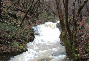
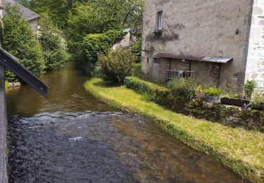
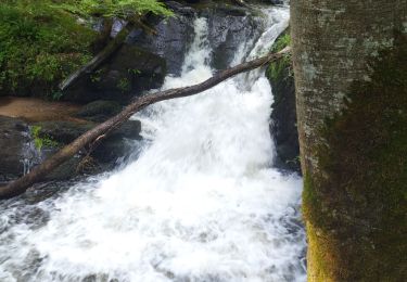
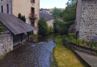
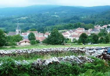
Ruta Senderismo de 8,4 km a descubrir en Auvergne-Rhône-Alpes, Puy-de-Dôme, Lachaux. Esta ruta ha sido propuesta por JackPG.
Descripción
Parcours inspiré par l’équipe municipale de Lachaux.
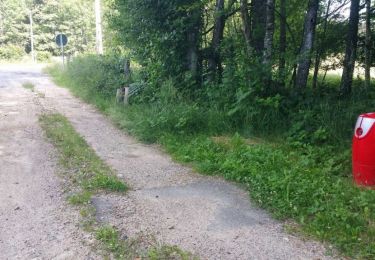
Parcours balisé avec flèches bleues au départ de Lachaux(Place).
Localización
País:
France
Región :
Auvergne-Rhône-Alpes
Departamento/provincia :
Puy-de-Dôme
Municipio :
Lachaux
Localidad:
Unknown
Salida:(Dec)
Salida:(UTM)
545857 ; 5093621 (31T) N.
Comentarios
Excursiones cerca
![Excursión Senderismo Ferrières-sur-Sichon - Balade autour de Ferrières sur Sichon - Photo](https://media.geolcdn.com/t/375/260/ext.jpg?maxdim=2&url=https%3A%2F%2Fservices.sitytrail.com%2FGeolivesWS%2FDownloadMedia.ashx%3FTrailID%3D107641%26Media%3D12629_1.jpg)
![Senderismo Senderismo](https://static1.geolcdn.com/sitytour/trail-icons/101.png)
Balade autour de Ferrières sur Sichon
Senderismo
Medio
(2)
Ferrières-sur-Sichon,
Auvergne-Rhône-Alpes,
Allier,
France
![](/images/other/stat-length.png)
7,4 km | 10,8 km-effort
2h 15min
![](https://static1.geolcdn.com/siteimages/upload/files/16400158638029165_repeat_loop_refresh_sync_direction_icon.png)
Sí
![Excursión Senderismo Ferrières-sur-Sichon - Arboretum - Photo](https://media.geolcdn.com/t/375/260/fe93d646-9efb-43e9-aec5-f16b1537551d.jpg&format=jpg&maxdim=2)
![Senderismo Senderismo](https://static1.geolcdn.com/sitytour/trail-icons/101.png)
Arboretum
Senderismo
Muy fácil
Ferrières-sur-Sichon,
Auvergne-Rhône-Alpes,
Allier,
France
![](/images/other/stat-length.png)
3 km | 4,5 km-effort
1h 2min
![](https://static1.geolcdn.com/siteimages/upload/files/16400158638029165_repeat_loop_refresh_sync_direction_icon.png)
No
![Excursión Senderismo Ferrières-sur-Sichon - Grotte des fées y cascade - Photo](https://media.geolcdn.com/t/375/260/ef8e8d52-f895-455d-a25d-963d7668436d.jpg&format=jpg&maxdim=2)
![Senderismo Senderismo](https://static1.geolcdn.com/sitytour/trail-icons/101.png)
Grotte des fées y cascade
Senderismo
Muy fácil
Ferrières-sur-Sichon,
Auvergne-Rhône-Alpes,
Allier,
France
![](/images/other/stat-length.png)
5,1 km | 6,7 km-effort
1h 15min
![](https://static1.geolcdn.com/siteimages/upload/files/16400158638029165_repeat_loop_refresh_sync_direction_icon.png)
Sí
![Excursión Ruta Ferrières-sur-Sichon - circuit du moulin neuf - Photo](https://media.geolcdn.com/t/375/260/beb3bba3-aa51-4c33-bd90-480ca60c9eae.jpg&format=jpg&maxdim=2)
![Ruta Ruta](https://static1.geolcdn.com/sitytour/trail-icons/104.png)
circuit du moulin neuf
Ruta
Fácil
Ferrières-sur-Sichon,
Auvergne-Rhône-Alpes,
Allier,
France
![](/images/other/stat-length.png)
12,3 km | 17,8 km-effort
1h 15min
![](https://static1.geolcdn.com/siteimages/upload/files/16400158638029165_repeat_loop_refresh_sync_direction_icon.png)
Sí
![Excursión A pie Lachaux - Le Rez de Sol - Photo](https://media.geolcdn.com/t/375/260/3c6e9ac5-80d8-4b51-813b-504d092dd950.jpeg&format=jpg&maxdim=2)
![A pie A pie](https://static1.geolcdn.com/sitytour/trail-icons/100.png)
Le Rez de Sol
A pie
Fácil
Lachaux,
Auvergne-Rhône-Alpes,
Puy-de-Dôme,
France
![](/images/other/stat-length.png)
10,7 km | 16,8 km-effort
3h 49min
![](https://static1.geolcdn.com/siteimages/upload/files/16400158638029165_repeat_loop_refresh_sync_direction_icon.png)
Sí
![Excursión Otra actividad Lachaux - Rez de.Sol - Photo](https://media.geolcdn.com/t/375/260/ext.jpg?maxdim=2&url=https%3A%2F%2Fstatic1.geolcdn.com%2Fsiteimages%2Fupload%2Ffiles%2F1545311037marcheuse_200dpi.jpg)
![Otra actividad Otra actividad](https://static1.geolcdn.com/sitytour/trail-icons/900.png)
Rez de.Sol
Otra actividad
Muy fácil
(1)
Lachaux,
Auvergne-Rhône-Alpes,
Puy-de-Dôme,
France
![](/images/other/stat-length.png)
22 km | 31 km-effort
8h 23min
![](https://static1.geolcdn.com/siteimages/upload/files/16400158638029165_repeat_loop_refresh_sync_direction_icon.png)
Sí
![Excursión Bici de montaña La Guillermie - Les Moulins au creux des vallées du Terrasson et du Theux - La Guillermie - Photo](https://media.geolcdn.com/t/375/260/ext.jpg?maxdim=2&url=https%3A%2F%2Fservices.sitytrail.com%2FGeolivesWS%2FDownloadMedia.ashx%3FTrailID%3D316921%26Media%3D16023_6.jpg)
![Bici de montaña Bici de montaña](https://static1.geolcdn.com/sitytour/trail-icons/202.png)
Les Moulins au creux des vallées du Terrasson et du Theux - La Guillermie
Bici de montaña
Muy difícil
La Guillermie,
Auvergne-Rhône-Alpes,
Allier,
France
![](/images/other/stat-length.png)
42 km | 61 km-effort
4h 15min
![](https://static1.geolcdn.com/siteimages/upload/files/16400158638029165_repeat_loop_refresh_sync_direction_icon.png)
Sí
![Excursión Senderismo Lachaux - Autour du Rez de Sol - Lachaux - Photo](https://media.geolcdn.com/t/375/260/ext.jpg?maxdim=2&url=https%3A%2F%2Fservices.sitytrail.com%2FGeolivesWS%2FDownloadMedia.ashx%3FTrailID%3D106774%26Media%3D11454_2.jpg)
![Senderismo Senderismo](https://static1.geolcdn.com/sitytour/trail-icons/101.png)
Autour du Rez de Sol - Lachaux
Senderismo
Difícil
Lachaux,
Auvergne-Rhône-Alpes,
Puy-de-Dôme,
France
![](/images/other/stat-length.png)
10,9 km | 17 km-effort
3h 0min
![](https://static1.geolcdn.com/siteimages/upload/files/16400158638029165_repeat_loop_refresh_sync_direction_icon.png)
Sí
![Excursión Otra actividad Lachaux - lachaux - Photo](https://media.geolcdn.com/t/375/260/ext.jpg?maxdim=2&url=https%3A%2F%2Fservices.sitytrail.com%2FGeolivesWS%2FDownloadMedia.ashx%3FTrailID%3D709002%26Media%3Dfix__20170305105526.jpg)
![Otra actividad Otra actividad](https://static1.geolcdn.com/sitytour/trail-icons/900.png)
lachaux
Otra actividad
Muy fácil
Lachaux,
Auvergne-Rhône-Alpes,
Puy-de-Dôme,
France
![](/images/other/stat-length.png)
21 km | 30 km-effort
5h 37min
![](https://static1.geolcdn.com/siteimages/upload/files/16400158638029165_repeat_loop_refresh_sync_direction_icon.png)
Sí