![](/images/other/stat-length.png)
![Excursión Senderismo Servance-Miellin - Virée au milieu des Mille Etangs - Photo](https://media.geolcdn.com/t/1900/400/ext.pjpeg?maxdim=2&url=https%3A%2F%2Fstatic1.geolcdn.com%2Fsiteimages%2Fupload%2Ffiles%2F1553511878bg_sport_marche.png)
Virée au milieu des Mille Etangs
jeanclaude12
Usuario
![Longitud](/images/other/stat-length.png)
Longitud
7 km
![Altitud máxima](https://static1.geolcdn.com/siteimages/upload/files/1508320355ic_sort_altitude_max_24dp.png)
Altitud máxima
623 m
![Desnivel positivo](https://static1.geolcdn.com/siteimages/upload/files/1508320355ic_sort_den_pos_24dp.png)
Desnivel positivo
85 m
![Km-Effort](/images/other/stat-length.png)
Km-Effort
8,2 km
![Altitud mínima](https://static1.geolcdn.com/siteimages/upload/files/1508320355ic_sort_altitude_min_24dp.png)
Altitud mínima
583 m
![Desnivel negativo](https://static1.geolcdn.com/siteimages/upload/files/1508320355ic_sort_den_neg_24dp.png)
Desnivel negativo
83 m
![Boucle](https://static1.geolcdn.com/siteimages/upload/files/16400158638029165_repeat_loop_refresh_sync_direction_icon.png)
Boucle
Sí
Fecha de creación :
2016-04-02 00:00:00.0
Última modificación :
2016-04-02 00:00:00.0
![Senderismo](https://static1.geolcdn.com/sitytour/trail-icons/101.png)
2h31
Dificultad : Fácil
![Escanee este código QR para abrir la excursión en la aplicación SityTrail](https://capi.geolives.com/qq0zvz2zws4bq2lad0pu/sitytour/trails/547944/qr.png?size=200)
Aplicación GPS de excursión GRATIS
A propósito
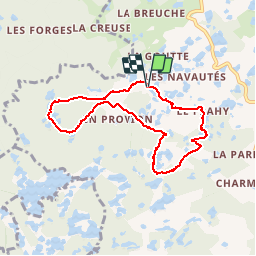
Ruta Senderismo de 7 km a descubrir en Borgoña-Franco Condado, Alto Saona, Servance-Miellin. Esta ruta ha sido propuesta por jeanclaude12.
Descripción
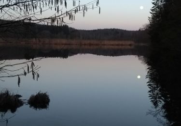
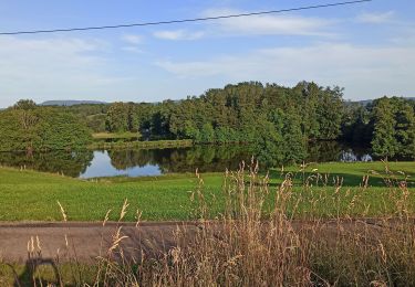
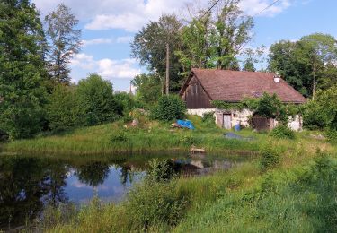
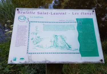
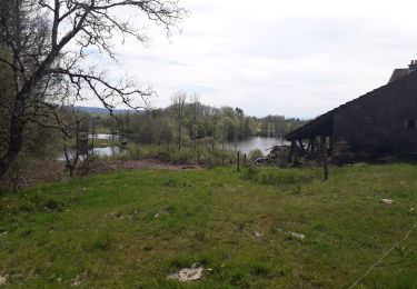
Agréable randonnée de sept kilomètres au départ du Pré-Guenée vers les nombreux Etangs du Frahier.
Localización
País:
France
Región :
Borgoña-Franco Condado
Departamento/provincia :
Alto Saona
Municipio :
Servance-Miellin
Localidad:
Servance
Salida:(Dec)
Salida:(UTM)
324278 ; 5300821 (32T) N.
Comentarios
Excursiones cerca
![Excursión Senderismo Beulotte-Saint-Laurent - Randonnée des étangs - Beulotte Saint Laurent - Photo](https://media.geolcdn.com/t/375/260/ext.jpg?maxdim=2&url=https%3A%2F%2Fservices.sitytrail.com%2FGeolivesWS%2FDownloadMedia.ashx%3FTrailID%3D107231%26Media%3D12098_5.jpg)
![Senderismo Senderismo](https://static1.geolcdn.com/sitytour/trail-icons/101.png)
Randonnée des étangs - Beulotte Saint Laurent
Senderismo
Medio
(4)
Beulotte-Saint-Laurent,
Borgoña-Franco Condado,
Alto Saona,
France
![](/images/other/stat-length.png)
10,7 km | 13,9 km-effort
2h 30min
![](https://static1.geolcdn.com/siteimages/upload/files/16400158638029165_repeat_loop_refresh_sync_direction_icon.png)
Sí
![Excursión Senderismo Faucogney-et-la-Mer - 08-02-20 La mer, étang de Pierre Plate et retour. - Photo](https://media.geolcdn.com/t/375/260/1db8c6b9-2ea1-4f8e-aef5-d4d9373f14e8.jpg&format=jpg&maxdim=2)
![Senderismo Senderismo](https://static1.geolcdn.com/sitytour/trail-icons/101.png)
08-02-20 La mer, étang de Pierre Plate et retour.
Senderismo
Muy fácil
(1)
Faucogney-et-la-Mer,
Borgoña-Franco Condado,
Alto Saona,
France
![](/images/other/stat-length.png)
9,9 km | 12,3 km-effort
2h 4min
![](https://static1.geolcdn.com/siteimages/upload/files/16400158638029165_repeat_loop_refresh_sync_direction_icon.png)
Sí
![Excursión Senderismo Beulotte-Saint-Laurent - Beulotte-Saint-Laurent 13 700m + 317m - Photo](https://media.geolcdn.com/t/375/260/ext.jpg?maxdim=2&url=https%3A%2F%2Fstatic1.geolcdn.com%2Fsiteimages%2Fupload%2Ffiles%2F1553511878bg_sport_marche.png)
![Senderismo Senderismo](https://static1.geolcdn.com/sitytour/trail-icons/101.png)
Beulotte-Saint-Laurent 13 700m + 317m
Senderismo
Fácil
(1)
Beulotte-Saint-Laurent,
Borgoña-Franco Condado,
Alto Saona,
France
![](/images/other/stat-length.png)
13,7 km | 17,9 km-effort
3h 50min
![](https://static1.geolcdn.com/siteimages/upload/files/16400158638029165_repeat_loop_refresh_sync_direction_icon.png)
Sí
![Excursión Senderismo Esmoulières - 08-07-23 circuit du plateau d'Esmoulieres - Photo](https://media.geolcdn.com/t/375/260/21f889c5-6bb0-42f1-a5cd-25c10161a5bd.jpg&format=jpg&maxdim=2)
![Senderismo Senderismo](https://static1.geolcdn.com/sitytour/trail-icons/101.png)
08-07-23 circuit du plateau d'Esmoulieres
Senderismo
Medio
Esmoulières,
Borgoña-Franco Condado,
Alto Saona,
France
![](/images/other/stat-length.png)
8,7 km | 11 km-effort
2h 2min
![](https://static1.geolcdn.com/siteimages/upload/files/16400158638029165_repeat_loop_refresh_sync_direction_icon.png)
Sí
![Excursión Senderismo Esmoulières - Esmoulières rando réelle - Photo](https://media.geolcdn.com/t/375/260/2ad0b972-a66a-4cdb-926e-a4b4f6e7eb9d.jpg&format=jpg&maxdim=2)
![Senderismo Senderismo](https://static1.geolcdn.com/sitytour/trail-icons/101.png)
Esmoulières rando réelle
Senderismo
Medio
Esmoulières,
Borgoña-Franco Condado,
Alto Saona,
France
![](/images/other/stat-length.png)
9,2 km | 11,5 km-effort
3h 11min
![](https://static1.geolcdn.com/siteimages/upload/files/16400158638029165_repeat_loop_refresh_sync_direction_icon.png)
Sí
![Excursión Senderismo Servance-Miellin - 20230616 la petite Finlande - Photo](https://media.geolcdn.com/t/375/260/b19527b0-70e6-4e00-b48b-d0fb85eecf23.jpg&format=jpg&maxdim=2)
![Senderismo Senderismo](https://static1.geolcdn.com/sitytour/trail-icons/101.png)
20230616 la petite Finlande
Senderismo
Medio
Servance-Miellin,
Borgoña-Franco Condado,
Alto Saona,
France
![](/images/other/stat-length.png)
8,4 km | 10 km-effort
3h 25min
![](https://static1.geolcdn.com/siteimages/upload/files/16400158638029165_repeat_loop_refresh_sync_direction_icon.png)
Sí
![Excursión Senderismo Faucogney-et-la-Mer - la mzr - Photo](https://media.geolcdn.com/t/375/260/4085d514-fed2-4f1a-a225-1e5c9d3a718a.jpg&format=jpg&maxdim=2)
![Senderismo Senderismo](https://static1.geolcdn.com/sitytour/trail-icons/101.png)
la mzr
Senderismo
Muy difícil
Faucogney-et-la-Mer,
Borgoña-Franco Condado,
Alto Saona,
France
![](/images/other/stat-length.png)
18,7 km | 24 km-effort
6h 17min
![](https://static1.geolcdn.com/siteimages/upload/files/16400158638029165_repeat_loop_refresh_sync_direction_icon.png)
Sí
![Excursión Senderismo Beulotte-Saint-Laurent - Beulotte St Laurent - le plateau des Mille Etangs - Photo](https://media.geolcdn.com/t/375/260/e526a3c8-361b-4678-a970-15d98b11e7c3.jpg&format=jpg&maxdim=2)
![Senderismo Senderismo](https://static1.geolcdn.com/sitytour/trail-icons/101.png)
Beulotte St Laurent - le plateau des Mille Etangs
Senderismo
Difícil
Beulotte-Saint-Laurent,
Borgoña-Franco Condado,
Alto Saona,
France
![](/images/other/stat-length.png)
22 km | 28 km-effort
4h 45min
![](https://static1.geolcdn.com/siteimages/upload/files/16400158638029165_repeat_loop_refresh_sync_direction_icon.png)
Sí
![Excursión Senderismo Esmoulières - randonnée Esmoulières - Photo](https://media.geolcdn.com/t/375/260/7f47e7bf-f81f-49bc-a1e2-a515b0b4f26a.jpg&format=jpg&maxdim=2)
![Senderismo Senderismo](https://static1.geolcdn.com/sitytour/trail-icons/101.png)
randonnée Esmoulières
Senderismo
Medio
Esmoulières,
Borgoña-Franco Condado,
Alto Saona,
France
![](/images/other/stat-length.png)
8,3 km | 10,5 km-effort
2h 4min
![](https://static1.geolcdn.com/siteimages/upload/files/16400158638029165_repeat_loop_refresh_sync_direction_icon.png)
Sí