![](/images/other/stat-length.png)
![Excursión Senderismo Saxon-Sion - Sion - Photo](https://media.geolcdn.com/t/1900/400/ext.pjpeg?maxdim=2&url=https%3A%2F%2Fstatic1.geolcdn.com%2Fsiteimages%2Fupload%2Ffiles%2F1553511878bg_sport_marche.png)
Sion
DanielROLLET
Usuario
![Longitud](/images/other/stat-length.png)
Longitud
12,4 km
![Altitud máxima](https://static1.geolcdn.com/siteimages/upload/files/1508320355ic_sort_altitude_max_24dp.png)
Altitud máxima
531 m
![Desnivel positivo](https://static1.geolcdn.com/siteimages/upload/files/1508320355ic_sort_den_pos_24dp.png)
Desnivel positivo
293 m
![Km-Effort](/images/other/stat-length.png)
Km-Effort
16,3 km
![Altitud mínima](https://static1.geolcdn.com/siteimages/upload/files/1508320355ic_sort_altitude_min_24dp.png)
Altitud mínima
396 m
![Desnivel negativo](https://static1.geolcdn.com/siteimages/upload/files/1508320355ic_sort_den_neg_24dp.png)
Desnivel negativo
294 m
![Boucle](https://static1.geolcdn.com/siteimages/upload/files/16400158638029165_repeat_loop_refresh_sync_direction_icon.png)
Boucle
Sí
Fecha de creación :
2016-03-31 00:00:00.0
Última modificación :
2016-03-31 00:00:00.0
![Senderismo](https://static1.geolcdn.com/sitytour/trail-icons/101.png)
3h31
Dificultad : Muy fácil
![Escanee este código QR para abrir la excursión en la aplicación SityTrail](https://capi.geolives.com/qq0zvz2zws4bq2lad0pu/sitytour/trails/546736/qr.png?size=200)
Aplicación GPS de excursión GRATIS
A propósito
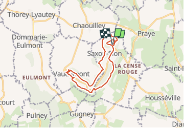
Ruta Senderismo de 12,4 km a descubrir en Gran Este, Meurthe y Mosela, Saxon-Sion. Esta ruta ha sido propuesta por DanielROLLET.
Descripción
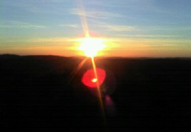
balisage anneaux rouges et anneaux vertsDurée 3h pour 12,3kmDénivelé cumulé 273mParking de la basilique : se diriger le long du parcours sonore et descendre à droite après 100m
Localización
País:
France
Región :
Gran Este
Departamento/provincia :
Meurthe y Mosela
Municipio :
Saxon-Sion
Localidad:
Unknown
Salida:(Dec)
Salida:(UTM)
284338 ; 5368194 (32U) N.
Comentarios
Excursiones cerca
![Excursión A pie Vaudémont - Circuit Barrès - Brunehaut - Photo](https://media.geolcdn.com/t/375/260/4379cc40-7f33-4534-895d-40998ea52ef9.jpeg&format=jpg&maxdim=2)
![A pie A pie](https://static1.geolcdn.com/sitytour/trail-icons/100.png)
Circuit Barrès - Brunehaut
A pie
Fácil
Vaudémont,
Gran Este,
Meurthe y Mosela,
France
![](/images/other/stat-length.png)
8,4 km | 10,7 km-effort
2h 26min
![](https://static1.geolcdn.com/siteimages/upload/files/16400158638029165_repeat_loop_refresh_sync_direction_icon.png)
Sí
![Excursión Senderismo Saxon-Sion - Sion - Photo](https://media.geolcdn.com/t/375/260/ext.jpg?maxdim=2&url=https%3A%2F%2Fstatic1.geolcdn.com%2Fsiteimages%2Fupload%2Ffiles%2F1553511878bg_sport_marche.png)
![Senderismo Senderismo](https://static1.geolcdn.com/sitytour/trail-icons/101.png)
Sion
Senderismo
Muy fácil
(1)
Saxon-Sion,
Gran Este,
Meurthe y Mosela,
France
![](/images/other/stat-length.png)
12,5 km | 16,2 km-effort
4h 40min
![](https://static1.geolcdn.com/siteimages/upload/files/16400158638029165_repeat_loop_refresh_sync_direction_icon.png)
Sí
![Excursión Senderismo Praye - PRAYE - LA COLLINE DE SION-VAUDEMONT - Photo](https://media.geolcdn.com/t/375/260/f6dfea2b-18d4-4541-a670-282ca29a8c57.jpg&format=jpg&maxdim=2)
![Senderismo Senderismo](https://static1.geolcdn.com/sitytour/trail-icons/101.png)
PRAYE - LA COLLINE DE SION-VAUDEMONT
Senderismo
Fácil
(1)
Praye,
Gran Este,
Meurthe y Mosela,
France
![](/images/other/stat-length.png)
16,6 km | 22 km-effort
8h 52min
![](https://static1.geolcdn.com/siteimages/upload/files/16400158638029165_repeat_loop_refresh_sync_direction_icon.png)
Sí
![Excursión sport Vaudémont - Vaudemont - Photo](https://media.geolcdn.com/t/375/260/3e0597da-804d-40ff-aac7-534e403227a8.jpg&format=jpg&maxdim=2)
Vaudemont
sport
Muy fácil
Vaudémont,
Gran Este,
Meurthe y Mosela,
France
![](/images/other/stat-length.png)
5 km | 6,4 km-effort
Desconocido
![](https://static1.geolcdn.com/siteimages/upload/files/16400158638029165_repeat_loop_refresh_sync_direction_icon.png)
Sí
![Excursión Senderismo Saxon-Sion - sion - Photo](https://media.geolcdn.com/t/375/260/9578318c-4e9b-48e6-b13f-618e356491c1.jpg&format=jpg&maxdim=2)
![Senderismo Senderismo](https://static1.geolcdn.com/sitytour/trail-icons/101.png)
sion
Senderismo
Medio
Saxon-Sion,
Gran Este,
Meurthe y Mosela,
France
![](/images/other/stat-length.png)
12,2 km | 16 km-effort
4h 36min
![](https://static1.geolcdn.com/siteimages/upload/files/16400158638029165_repeat_loop_refresh_sync_direction_icon.png)
Sí
![Excursión Senderismo Praye - tour de Sion 54 - Photo](https://media.geolcdn.com/t/375/260/efd9d13b-96a3-4b6c-aa74-e6fa88929e0e.jpg&format=jpg&maxdim=2)
![Senderismo Senderismo](https://static1.geolcdn.com/sitytour/trail-icons/101.png)
tour de Sion 54
Senderismo
Medio
Praye,
Gran Este,
Meurthe y Mosela,
France
![](/images/other/stat-length.png)
18,3 km | 25 km-effort
5h 8min
![](https://static1.geolcdn.com/siteimages/upload/files/16400158638029165_repeat_loop_refresh_sync_direction_icon.png)
Sí
![Excursión Senderismo Vaudémont - 2012-01-15 18h02m24 - Photo](https://media.geolcdn.com/t/375/260/ext.jpg?maxdim=2&url=https%3A%2F%2Fservices.sitytrail.com%2FGeolivesWS%2FDownloadMedia.ashx%3FTrailID%3D98704%26Media%3D20120115165929.jpeg)
![Senderismo Senderismo](https://static1.geolcdn.com/sitytour/trail-icons/101.png)
2012-01-15 18h02m24
Senderismo
Fácil
Vaudémont,
Gran Este,
Meurthe y Mosela,
France
![](/images/other/stat-length.png)
4 km | 4,8 km-effort
1h 4min
![](https://static1.geolcdn.com/siteimages/upload/files/16400158638029165_repeat_loop_refresh_sync_direction_icon.png)
Sí
![Excursión Senderismo Vaudémont - Randoguide - Photo](https://media.geolcdn.com/t/375/260/ext.jpg?maxdim=2&url=https%3A%2F%2Fservices.sitytrail.com%2FGeolivesWS%2FDownloadMedia.ashx%3FTrailID%3D90656%26Media%3D20111106174526.jpeg)
![Senderismo Senderismo](https://static1.geolcdn.com/sitytour/trail-icons/101.png)
Randoguide
Senderismo
Medio
Vaudémont,
Gran Este,
Meurthe y Mosela,
France
![](/images/other/stat-length.png)
9,9 km | 12,9 km-effort
2h 45min
![](https://static1.geolcdn.com/siteimages/upload/files/16400158638029165_repeat_loop_refresh_sync_direction_icon.png)
Sí
![Excursión Senderismo Saxon-Sion - Sion - Photo](https://media.geolcdn.com/t/375/260/ext.jpg?maxdim=2&url=https%3A%2F%2Fstatic1.geolcdn.com%2Fsiteimages%2Fupload%2Ffiles%2F1553511878bg_sport_marche.png)
![Senderismo Senderismo](https://static1.geolcdn.com/sitytour/trail-icons/101.png)
je valide