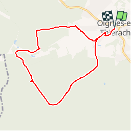
![](/images/other/stat-length.png)
![Excursión Senderismo Viroinval - RF-Na-12 Oignies - Petite-boucle - Photo](https://media.geolcdn.com/t/1900/400/ext.pjpeg?maxdim=2&url=https%3A%2F%2Fstatic1.geolcdn.com%2Fsiteimages%2Fupload%2Ffiles%2F1553511878bg_sport_marche.png)
RF-Na-12 Oignies - Petite-boucle
GR Rando
Randonnez sur et autour des GR ® wallons (Sentiers de Grande Randonnée). PRO
![Longitud](/images/other/stat-length.png)
![Altitud máxima](https://static1.geolcdn.com/siteimages/upload/files/1508320355ic_sort_altitude_max_24dp.png)
![Desnivel positivo](https://static1.geolcdn.com/siteimages/upload/files/1508320355ic_sort_den_pos_24dp.png)
![Km-Effort](/images/other/stat-length.png)
![Altitud mínima](https://static1.geolcdn.com/siteimages/upload/files/1508320355ic_sort_altitude_min_24dp.png)
![Desnivel negativo](https://static1.geolcdn.com/siteimages/upload/files/1508320355ic_sort_den_neg_24dp.png)
![Boucle](https://static1.geolcdn.com/siteimages/upload/files/16400158638029165_repeat_loop_refresh_sync_direction_icon.png)
![Senderismo](https://static1.geolcdn.com/sitytour/trail-icons/101.png)
2h10
Dificultad : Fácil
![Escanee este código QR para abrir la excursión en la aplicación SityTrail](https://capi.geolives.com/qq0zvz2zws4bq2lad0pu/sitytour/trails/545773/qr.png?size=200)
Aplicación GPS de excursión GRATIS
A propósito
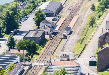
Ruta Senderismo de 7,9 km a descubrir en Valonia, Namur, Viroinval. Esta ruta ha sido propuesta por GR Rando.
Descripción
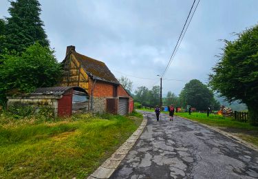
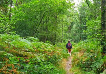
Flânerie en Thiérache
Dans quel type de paysage notre famille randonne-t-elle ?
Hormis le village de Oignies-en-Thiérache, splendide parcours en forêt.
Quelle difficulté pour notre famille Rando?
Aucune.
Combien de kilomètres ?
8 km pour la petite boucle.
Sur quel GR randonne-t-elle ?
Sur le GR 12, qui relie Amsterdam à Paris.
Où démarre-t-elle ?
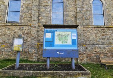
Près de l’église d’Oignies, quelques places de parking sont parfois disponibles.
Comment y arrive-t-elle ?
Par la N99 Doische - Couvin. À Olloy-sur-Viroin, prendre la direction d’Oignies.
Par la N151 Givet - Fumay. À Fumay, obliquer vers Oignies.
Par la N5 Charleroi - Couvin. À Couvin, direction Viroinval, jusqu’à Olloy-sur-Viroin. À Olloy, prendre à droite vers Oignies.
Que découvre-t-elle aujourd’hui ?
Notre famille a l’embarras du choix des attractions dans la région d’Oignies-en-Thiérache. Pour ce faire, elle doit se transporter à Brûly-de-Pesche, à Cul-des-Sarts ou à Treignes.
Quelle est la carte IGN de référence ?
Cartes IGN au 1:20 000, 58/5-6 « Viroinval » et 63/1-2 « Moulin Manteau - Moulin de Chestion ».
Localización
Comentarios
Excursiones cerca
![Senderismo Senderismo](https://static1.geolcdn.com/sitytour/trail-icons/101.png)
Senderismo
![](/images/other/stat-length.png)
![](https://static1.geolcdn.com/siteimages/upload/files/16400158638029165_repeat_loop_refresh_sync_direction_icon.png)
![Excursión Senderismo Viroinval - RF-Na-12 Oignies - Grande-boucle - Photo](https://media.geolcdn.com/t/375/260/ext.jpg?maxdim=2&url=https%3A%2F%2Fstatic1.geolcdn.com%2Fsiteimages%2Fupload%2Ffiles%2F1553511878bg_sport_marche.png)
![Senderismo Senderismo](https://static1.geolcdn.com/sitytour/trail-icons/101.png)
Senderismo
![](/images/other/stat-length.png)
![](https://static1.geolcdn.com/siteimages/upload/files/16400158638029165_repeat_loop_refresh_sync_direction_icon.png)
![Excursión Senderismo Viroinval - Balade à Le Mesnil - Viroinval - Photo](https://media.geolcdn.com/t/375/260/040808b9-fcd8-4fc3-8c4a-eb6f326e6772.jpeg&format=jpg&maxdim=2)
![Senderismo Senderismo](https://static1.geolcdn.com/sitytour/trail-icons/101.png)
Senderismo
![](/images/other/stat-length.png)
![](https://static1.geolcdn.com/siteimages/upload/files/16400158638029165_repeat_loop_refresh_sync_direction_icon.png)
![Excursión Senderismo Viroinval - 2024-03-19_14h55m08_OTH-A0-008T-2Z7M - Photo](https://media.geolcdn.com/t/375/260/3b9face2-c744-4af6-a62d-817b6f505d56.jpg&format=jpg&maxdim=2)
![Senderismo Senderismo](https://static1.geolcdn.com/sitytour/trail-icons/101.png)
Senderismo
![](/images/other/stat-length.png)
![](https://static1.geolcdn.com/siteimages/upload/files/16400158638029165_repeat_loop_refresh_sync_direction_icon.png)
![Excursión Senderismo Viroinval - Balade à Regniessart - Viroinval - Photo](https://media.geolcdn.com/t/375/260/a5d602e3-469f-47f0-b83f-6a311b5da224.jpeg&format=jpg&maxdim=2)
![Senderismo Senderismo](https://static1.geolcdn.com/sitytour/trail-icons/101.png)
Senderismo
![](/images/other/stat-length.png)
![](https://static1.geolcdn.com/siteimages/upload/files/16400158638029165_repeat_loop_refresh_sync_direction_icon.png)
![Excursión Senderismo Viroinval - Balade à Oignies-en-Thiérache - Le Ry d'Alise - Photo](https://media.geolcdn.com/t/375/260/87d4fc47-9859-4088-b6f4-a15d14542517.jpeg&format=jpg&maxdim=2)
![Senderismo Senderismo](https://static1.geolcdn.com/sitytour/trail-icons/101.png)
Senderismo
![](/images/other/stat-length.png)
![](https://static1.geolcdn.com/siteimages/upload/files/16400158638029165_repeat_loop_refresh_sync_direction_icon.png)
![Excursión A pie Fumay - Les Ardoisières de Fumay - Photo](https://media.geolcdn.com/t/375/260/0be384a9-b742-44ce-bbb3-4994f25cd7ac.jpeg&format=jpg&maxdim=2)
![A pie A pie](https://static1.geolcdn.com/sitytour/trail-icons/100.png)
A pie
![](/images/other/stat-length.png)
![](https://static1.geolcdn.com/siteimages/upload/files/16400158638029165_repeat_loop_refresh_sync_direction_icon.png)
![Excursión A pie Viroinval - Les Charmes - Photo](https://media.geolcdn.com/t/375/260/e06f8e5a-2196-4a8c-895b-a813e807cea3.jpeg&format=jpg&maxdim=2)
![A pie A pie](https://static1.geolcdn.com/sitytour/trail-icons/100.png)
![Excursión A pie Viroinval - Les Crêtes - Robertsart - Photo](https://media.geolcdn.com/t/375/260/95bd997e-996f-450d-98b8-1f50f91ce91a.jpeg&format=jpg&maxdim=2)
![A pie A pie](https://static1.geolcdn.com/sitytour/trail-icons/100.png)
A pie
![](/images/other/stat-length.png)
![](https://static1.geolcdn.com/siteimages/upload/files/16400158638029165_repeat_loop_refresh_sync_direction_icon.png)