![](/images/other/stat-length.png)
![Excursión Senderismo Stekene - Wullebos - Klein Sinaai (6km) (StepAway.be) - Photo](https://media.geolcdn.com/t/1900/400/ext.pjpeg?maxdim=2&url=https%3A%2F%2Fstatic1.geolcdn.com%2Fsiteimages%2Fupload%2Ffiles%2F1553511878bg_sport_marche.png)
Wullebos - Klein Sinaai (6km) (StepAway.be)
corry.vandenbroeke
Usuario
![Longitud](/images/other/stat-length.png)
Longitud
5,9 km
![Altitud máxima](https://static1.geolcdn.com/siteimages/upload/files/1508320355ic_sort_altitude_max_24dp.png)
Altitud máxima
17 m
![Desnivel positivo](https://static1.geolcdn.com/siteimages/upload/files/1508320355ic_sort_den_pos_24dp.png)
Desnivel positivo
45 m
![Km-Effort](/images/other/stat-length.png)
Km-Effort
6,5 km
![Altitud mínima](https://static1.geolcdn.com/siteimages/upload/files/1508320355ic_sort_altitude_min_24dp.png)
Altitud mínima
0 m
![Desnivel negativo](https://static1.geolcdn.com/siteimages/upload/files/1508320355ic_sort_den_neg_24dp.png)
Desnivel negativo
45 m
![Boucle](https://static1.geolcdn.com/siteimages/upload/files/16400158638029165_repeat_loop_refresh_sync_direction_icon.png)
Boucle
Sí
Fecha de creación :
2016-05-05 00:00:00.0
Última modificación :
2016-05-05 00:00:00.0
![Senderismo](https://static1.geolcdn.com/sitytour/trail-icons/101.png)
1h26
Dificultad : Fácil
![Escanee este código QR para abrir la excursión en la aplicación SityTrail](https://capi.geolives.com/qq0zvz2zws4bq2lad0pu/sitytour/trails/544433/qr.png?size=200)
Aplicación GPS de excursión GRATIS
A propósito
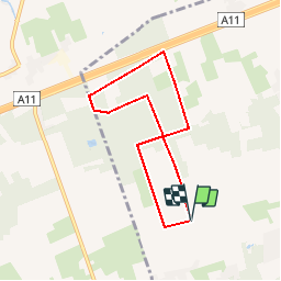
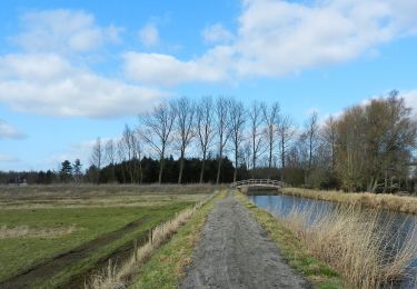
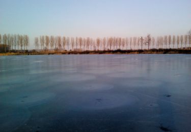
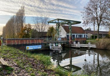
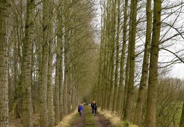
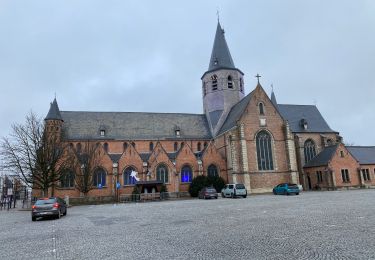
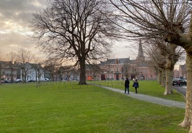
Ruta Senderismo de 5,9 km a descubrir en Flandes, Provincia de Flandes Oriental, Stekene. Esta ruta ha sido propuesta por corry.vandenbroeke.
Descripción
De wandeling begint in de Abelendreef - 9190 Klein Sinaai. Perfecte wandeling voor Nordic Walking omwille van de zachte ondergrond. (Aardeweg). Deze wandeling wordt U gratis aangeboden door www.StepAway.be
Localización
País:
Belgium
Región :
Flandes
Departamento/provincia :
Provincia de Flandes Oriental
Municipio :
Stekene
Localidad:
Stekene
Salida:(Dec)
Salida:(UTM)
569050 ; 5671784 (31U) N.
Comentarios
Excursiones cerca
![Excursión A pie Lokeren - Liniewegelroute - Photo](https://media.geolcdn.com/t/375/260/62ae4cc3-6e72-4c51-bc3b-95bdff6e887b.jpeg&format=jpg&maxdim=2)
![A pie A pie](https://static1.geolcdn.com/sitytour/trail-icons/100.png)
Liniewegelroute
A pie
Fácil
Lokeren,
Flandes,
Provincia de Flandes Oriental,
Belgium
![](/images/other/stat-length.png)
8,4 km | 9 km-effort
2h 2min
![](https://static1.geolcdn.com/siteimages/upload/files/16400158638029165_repeat_loop_refresh_sync_direction_icon.png)
Sí
![Excursión A pie Moerbeke - Pereboomsgat Wandelroute - Photo](https://media.geolcdn.com/t/375/260/3a2bc327-0df1-42c6-8878-457c212415cf.jpeg&format=jpg&maxdim=2)
![A pie A pie](https://static1.geolcdn.com/sitytour/trail-icons/100.png)
Pereboomsgat Wandelroute
A pie
Fácil
Moerbeke,
Flandes,
Provincia de Flandes Oriental,
Belgium
![](/images/other/stat-length.png)
8,5 km | 8,9 km-effort
2h 1min
![](https://static1.geolcdn.com/siteimages/upload/files/16400158638029165_repeat_loop_refresh_sync_direction_icon.png)
No
![Excursión Senderismo Moerbeke - Moerbeke 26,5 km - Photo](https://media.geolcdn.com/t/375/260/35628380-609b-479d-af04-77325e1722d8.jpg&format=jpg&maxdim=2)
![Senderismo Senderismo](https://static1.geolcdn.com/sitytour/trail-icons/101.png)
Moerbeke 26,5 km
Senderismo
Medio
Moerbeke,
Flandes,
Provincia de Flandes Oriental,
Belgium
![](/images/other/stat-length.png)
27 km | 28 km-effort
5h 44min
![](https://static1.geolcdn.com/siteimages/upload/files/16400158638029165_repeat_loop_refresh_sync_direction_icon.png)
Sí
![Excursión A pie Sint-Niklaas - Fondatie van Boudeloroute - Photo](https://media.geolcdn.com/t/375/260/8e5b7271-48e9-4cd7-899b-9ae7b9cc4a80.jpeg&format=jpg&maxdim=2)
![A pie A pie](https://static1.geolcdn.com/sitytour/trail-icons/100.png)
Fondatie van Boudeloroute
A pie
Fácil
Sint-Niklaas,
Flandes,
Provincia de Flandes Oriental,
Belgium
![](/images/other/stat-length.png)
6 km | 6,5 km-effort
1h 28min
![](https://static1.geolcdn.com/siteimages/upload/files/16400158638029165_repeat_loop_refresh_sync_direction_icon.png)
Sí
![Excursión A pie Stekene - Groene Puttenroute - Photo](https://media.geolcdn.com/t/375/260/b99a6f3f-47fb-4bb7-82aa-d55f15681684.jpeg&format=jpg&maxdim=2)
![A pie A pie](https://static1.geolcdn.com/sitytour/trail-icons/100.png)
Groene Puttenroute
A pie
Fácil
Stekene,
Flandes,
Provincia de Flandes Oriental,
Belgium
![](/images/other/stat-length.png)
7 km | 7,8 km-effort
1h 46min
![](https://static1.geolcdn.com/siteimages/upload/files/16400158638029165_repeat_loop_refresh_sync_direction_icon.png)
Sí
![Excursión Senderismo Stekene - Stekene 24 km - Photo](https://media.geolcdn.com/t/375/260/fec1aeec-483e-4c6f-b7bd-2e96b05a7549.jpg&format=jpg&maxdim=2)
![Senderismo Senderismo](https://static1.geolcdn.com/sitytour/trail-icons/101.png)
Stekene 24 km
Senderismo
Medio
Stekene,
Flandes,
Provincia de Flandes Oriental,
Belgium
![](/images/other/stat-length.png)
24 km | 26 km-effort
5h 33min
![](https://static1.geolcdn.com/siteimages/upload/files/16400158638029165_repeat_loop_refresh_sync_direction_icon.png)
Sí
![Excursión Senderismo Sint-Niklaas - Sinaai bis 22,9 km - Photo](https://media.geolcdn.com/t/375/260/9fd9e1dc-7fca-48aa-aa20-c76237cf4a8e.jpg&format=jpg&maxdim=2)
![Senderismo Senderismo](https://static1.geolcdn.com/sitytour/trail-icons/101.png)
Sinaai bis 22,9 km
Senderismo
Fácil
Sint-Niklaas,
Flandes,
Provincia de Flandes Oriental,
Belgium
![](/images/other/stat-length.png)
23 km | 24 km-effort
5h 12min
![](https://static1.geolcdn.com/siteimages/upload/files/16400158638029165_repeat_loop_refresh_sync_direction_icon.png)
Sí
![Excursión Senderismo Sint-Niklaas - Sinaai 23 km - Photo](https://media.geolcdn.com/t/375/260/41153e4c-b05c-4034-85e3-cf7e03465de5.jpg&format=jpg&maxdim=2)
![Senderismo Senderismo](https://static1.geolcdn.com/sitytour/trail-icons/101.png)
Sinaai 23 km
Senderismo
Fácil
Sint-Niklaas,
Flandes,
Provincia de Flandes Oriental,
Belgium
![](/images/other/stat-length.png)
23 km | 24 km-effort
5h 9min
![](https://static1.geolcdn.com/siteimages/upload/files/16400158638029165_repeat_loop_refresh_sync_direction_icon.png)
Sí
![Excursión Senderismo Lokeren - liniewegel - Photo](https://media.geolcdn.com/t/375/260/ext.jpg?maxdim=2&url=https%3A%2F%2Fstatic1.geolcdn.com%2Fsiteimages%2Fupload%2Ffiles%2F1553511878bg_sport_marche.png)
![Senderismo Senderismo](https://static1.geolcdn.com/sitytour/trail-icons/101.png)
liniewegel
Senderismo
Muy fácil
(1)
Lokeren,
Flandes,
Provincia de Flandes Oriental,
Belgium
![](/images/other/stat-length.png)
8,4 km | 9 km-effort
Desconocido
![](https://static1.geolcdn.com/siteimages/upload/files/16400158638029165_repeat_loop_refresh_sync_direction_icon.png)
Sí
Al veel wandelplezier gehad aan deze app. Heel concrete en juiste info, chapeau