![](/images/other/stat-length.png)
![Excursión Senderismo Namur - Balade dans le bois de la Vecquée à Malonne - Photo](https://media.geolcdn.com/t/1900/400/ext.pjpeg?maxdim=2&url=https%3A%2F%2Fstatic1.geolcdn.com%2Fsiteimages%2Fupload%2Ffiles%2F1553511878bg_sport_marche.png)
Balade dans le bois de la Vecquée à Malonne
PatCoria
Usuario
![Longitud](/images/other/stat-length.png)
Longitud
5,2 km
![Altitud máxima](https://static1.geolcdn.com/siteimages/upload/files/1508320355ic_sort_altitude_max_24dp.png)
Altitud máxima
223 m
![Desnivel positivo](https://static1.geolcdn.com/siteimages/upload/files/1508320355ic_sort_den_pos_24dp.png)
Desnivel positivo
93 m
![Km-Effort](/images/other/stat-length.png)
Km-Effort
6,5 km
![Altitud mínima](https://static1.geolcdn.com/siteimages/upload/files/1508320355ic_sort_altitude_min_24dp.png)
Altitud mínima
143 m
![Desnivel negativo](https://static1.geolcdn.com/siteimages/upload/files/1508320355ic_sort_den_neg_24dp.png)
Desnivel negativo
93 m
![Boucle](https://static1.geolcdn.com/siteimages/upload/files/16400158638029165_repeat_loop_refresh_sync_direction_icon.png)
Boucle
Sí
Fecha de creación :
2017-06-27 00:00:00.0
Última modificación :
2017-06-27 00:00:00.0
![Senderismo](https://static1.geolcdn.com/sitytour/trail-icons/101.png)
1h25
Dificultad : Fácil
![Escanee este código QR para abrir la excursión en la aplicación SityTrail](https://capi.geolives.com/qq0zvz2zws4bq2lad0pu/sitytour/trails/531324/qr.png?size=200)
Aplicación GPS de excursión GRATIS
A propósito
Ruta Senderismo de 5,2 km a descubrir en Valonia, Namur, Namur. Esta ruta ha sido propuesta por PatCoria.
Descripción
Belle balade dans le bois de la Vecquée. Parking au point de départ. Attention, les chiens doivent être tenus en laisse!
Localización
País:
Belgium
Región :
Valonia
Departamento/provincia :
Namur
Municipio :
Namur
Localidad:
Malonne
Salida:(Dec)
Salida:(UTM)
630016 ; 5589141 (31U) N.
Comentarios
Excursiones cerca
![Excursión Senderismo Namur - Balade dans le bois de la Vecquée - Photo](https://media.geolcdn.com/t/375/260/ext.jpg?maxdim=2&url=https%3A%2F%2Fservices.sitytrail.com%2FGeolivesWS%2FDownloadMedia.ashx%3FTrailID%3D116970%26Media%3D93b7e593-adca-4c1d-a47c-e05bb1cf45a1.JPG)
![Senderismo Senderismo](https://static1.geolcdn.com/sitytour/trail-icons/101.png)
Balade dans le bois de la Vecquée
Senderismo
Medio
(6)
Namur,
Valonia,
Namur,
Belgium
![](/images/other/stat-length.png)
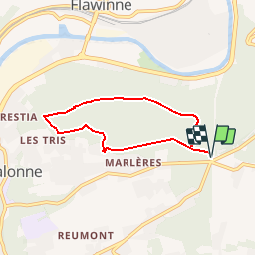
13,2 km | 18,4 km-effort
3h 20min
![](https://static1.geolcdn.com/siteimages/upload/files/16400158638029165_repeat_loop_refresh_sync_direction_icon.png)
Sí
![Excursión Senderismo Namur - Nuit du scoutisme - Namur - Photo](https://media.geolcdn.com/t/375/260/ext.jpg?maxdim=2&url=https%3A%2F%2Fmedia.geolcdn.com%2Ff%2F59c09917-a863-4933-801b-fff702066ffd.jpg)
![Senderismo Senderismo](https://static1.geolcdn.com/sitytour/trail-icons/101.png)
Nuit du scoutisme - Namur
Senderismo
Medio
(7)
Namur,
Valonia,
Namur,
Belgium
![](/images/other/stat-length.png)
5,5 km | 6,1 km-effort
1h 32min
![](https://static1.geolcdn.com/siteimages/upload/files/16400158638029165_repeat_loop_refresh_sync_direction_icon.png)
Sí
![Excursión Senderismo Namur - La Plante 16 Km - Photo](https://media.geolcdn.com/t/375/260/ext.jpg?maxdim=2&url=https%3A%2F%2Fmedia.geolcdn.com%2Ff%2Fd14bf9b4-85d7-458d-beb2-079d8e396b5c.jpeg)
![Senderismo Senderismo](https://static1.geolcdn.com/sitytour/trail-icons/101.png)
La Plante 16 Km
Senderismo
Fácil
(1)
Namur,
Valonia,
Namur,
Belgium
![](/images/other/stat-length.png)
15,9 km | 21 km-effort
5h 34min
![](https://static1.geolcdn.com/siteimages/upload/files/16400158638029165_repeat_loop_refresh_sync_direction_icon.png)
Sí
![Excursión Senderismo Namur - Balade à Wépion - Photo](https://media.geolcdn.com/t/375/260/ext.jpg?maxdim=2&url=https%3A%2F%2Fservices.sitytrail.com%2FGeolivesWS%2FDownloadMedia.ashx%3FTrailID%3D424647%26Media%3D68845f3c-9f68-429e-9990-62cb43748425.JPG)
![Senderismo Senderismo](https://static1.geolcdn.com/sitytour/trail-icons/101.png)
Balade à Wépion
Senderismo
Fácil
(4)
Namur,
Valonia,
Namur,
Belgium
![](/images/other/stat-length.png)
11,7 km | 15,2 km-effort
3h 15min
![](https://static1.geolcdn.com/siteimages/upload/files/16400158638029165_repeat_loop_refresh_sync_direction_icon.png)
Sí
![Excursión Senderismo Namur - La balade des quais à Namur - Photo](https://media.geolcdn.com/t/375/260/ext.jpg?maxdim=2&url=https%3A%2F%2Fservices.sitytrail.com%2FGeolivesWS%2FDownloadMedia.ashx%3FTrailID%3D362945%26Media%3D1faf5953-f3d8-4ec7-ad30-b2dea219bb51.JPG)
![Senderismo Senderismo](https://static1.geolcdn.com/sitytour/trail-icons/101.png)
La balade des quais à Namur
Senderismo
Muy fácil
(3)
Namur,
Valonia,
Namur,
Belgium
![](/images/other/stat-length.png)
7,6 km | 8,6 km-effort
1h 53min
![](https://static1.geolcdn.com/siteimages/upload/files/16400158638029165_repeat_loop_refresh_sync_direction_icon.png)
Sí
![Excursión Senderismo Namur - Des Fonds de Dave au Fonds de Lustin par le bois des Acremonts - Photo](https://media.geolcdn.com/t/375/260/ext.jpg?maxdim=2&url=https%3A%2F%2Fservices.sitytrail.com%2FGeolivesWS%2FDownloadMedia.ashx%3FTrailID%3D1050274%26Media%3D85d231a9-965a-4b59-b9e0-0ce337f3bdca.jpg)
![Senderismo Senderismo](https://static1.geolcdn.com/sitytour/trail-icons/101.png)
Des Fonds de Dave au Fonds de Lustin par le bois des Acremonts
Senderismo
Fácil
(4)
Namur,
Valonia,
Namur,
Belgium
![](/images/other/stat-length.png)
11,1 km | 15,6 km-effort
3h 6min
![](https://static1.geolcdn.com/siteimages/upload/files/16400158638029165_repeat_loop_refresh_sync_direction_icon.png)
Sí
![Excursión Bicicleta Namur - Route du vin un jour Route du vin toujours - Photo](https://media.geolcdn.com/t/375/260/ext.jpg?maxdim=2&url=https%3A%2F%2Fservices.sitytrail.com%2FGeolivesWS%2FDownloadMedia.ashx%3FTrailID%3D640338%26Media%3Dc3ae23a8-7b1c-4265-a2e6-0841c4658a8c.jpg)
![Bicicleta Bicicleta](https://static1.geolcdn.com/sitytour/trail-icons/200.png)
Route du vin un jour Route du vin toujours
Bicicleta
Fácil
(1)
Namur,
Valonia,
Namur,
Belgium
![](/images/other/stat-length.png)
33 km | 38 km-effort
2h 11min
![](https://static1.geolcdn.com/siteimages/upload/files/16400158638029165_repeat_loop_refresh_sync_direction_icon.png)
Sí
![Excursión Senderismo Namur - Dave, Lustin, Profondeville - Photo](https://media.geolcdn.com/t/375/260/ext.jpg?maxdim=2&url=https%3A%2F%2Fservices.sitytrail.com%2FGeolivesWS%2FDownloadMedia.ashx%3FTrailID%3D486371%26Media%3D6fa4536b-b0f9-4f9a-8886-2f8c865ac7dd.jpg)
![Senderismo Senderismo](https://static1.geolcdn.com/sitytour/trail-icons/101.png)
Dave, Lustin, Profondeville
Senderismo
Muy difícil
(1)
Namur,
Valonia,
Namur,
Belgium
![](/images/other/stat-length.png)
34 km | 45 km-effort
9h 34min
![](https://static1.geolcdn.com/siteimages/upload/files/16400158638029165_repeat_loop_refresh_sync_direction_icon.png)
Sí
![Excursión Senderismo Namur - ERPENT - Photo](https://media.geolcdn.com/t/375/260/ext.jpg?maxdim=2&url=https%3A%2F%2Fservices.sitytrail.com%2FGeolivesWS%2FDownloadMedia.ashx%3FTrailID%3D405889%26Media%3Dfix__20150409153931.jpg)
![Senderismo Senderismo](https://static1.geolcdn.com/sitytour/trail-icons/101.png)
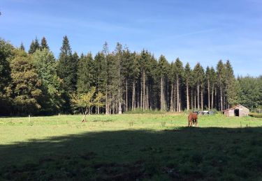
belle ballade dans les bois avec toutou