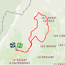
![](/images/other/stat-length.png)
![Excursión Raquetas de nieve Entremont-le-Vieux - Charteuse-Boucle du Grand Carroz - Photo](https://media.geolcdn.com/t/1900/400/ext.pjpeg?maxdim=2&url=https%3A%2F%2Fservices.sitytrail.com%2FGeolivesWS%2FDownloadMedia.ashx%3FTrailID%3D515656%26Media%3Dfix__20160121113615.jpg)
Charteuse-Boucle du Grand Carroz
patpounet73
Usuario
![Longitud](/images/other/stat-length.png)
![Altitud máxima](https://static1.geolcdn.com/siteimages/upload/files/1508320355ic_sort_altitude_max_24dp.png)
![Desnivel positivo](https://static1.geolcdn.com/siteimages/upload/files/1508320355ic_sort_den_pos_24dp.png)
![Km-Effort](/images/other/stat-length.png)
![Altitud mínima](https://static1.geolcdn.com/siteimages/upload/files/1508320355ic_sort_altitude_min_24dp.png)
![Desnivel negativo](https://static1.geolcdn.com/siteimages/upload/files/1508320355ic_sort_den_neg_24dp.png)
![Boucle](https://static1.geolcdn.com/siteimages/upload/files/16400158638029165_repeat_loop_refresh_sync_direction_icon.png)
![Raquetas de nieve](https://static1.geolcdn.com/sitytour/trail-icons/504.png)
3h30
Dificultad : Medio
![Escanee este código QR para abrir la excursión en la aplicación SityTrail](https://capi.geolives.com/qq0zvz2zws4bq2lad0pu/sitytour/trails/515656/qr.png?size=200)
Aplicación GPS de excursión GRATIS
A propósito
Ruta Raquetas de nieve de 8 km a descubrir en Auvergne-Rhône-Alpes, Saboya, Entremont-le-Vieux. Esta ruta ha sido propuesta por patpounet73.
Descripción
Départ depuis le foyer de ski de fond des Déserts d'Entremont. Circuit très bien balisé. Majeure partie du circuit en forêt. Petit effort à fournir pour la montée bien soutenue en direction du Montfred. Parcours agréable.
Localización
Comentarios
Excursiones cerca
![Excursión Senderismo Apremont - Mont Joigny, pte de la Georgat, la Lentille, le GD Carroz - Photo](https://media.geolcdn.com/t/375/260/34a799f3-15e1-4e29-b39c-0c906d59ce42.jpg&format=jpg&maxdim=2)
![Senderismo Senderismo](https://static1.geolcdn.com/sitytour/trail-icons/101.png)
Senderismo
![](/images/other/stat-length.png)
![](https://static1.geolcdn.com/siteimages/upload/files/16400158638029165_repeat_loop_refresh_sync_direction_icon.png)
![Excursión Senderismo Entremont-le-Vieux - Le Mont Granier par la cheminée de Tencovaz - Photo](https://media.geolcdn.com/t/375/260/ext.jpg?maxdim=2&url=https%3A%2F%2Fservices.sitytrail.com%2FGeolivesWS%2FDownloadMedia.ashx%3FTrailID%3D103708%26Media%3D6232_1.jpg)
![Senderismo Senderismo](https://static1.geolcdn.com/sitytour/trail-icons/101.png)
Senderismo
![](/images/other/stat-length.png)
![](https://static1.geolcdn.com/siteimages/upload/files/16400158638029165_repeat_loop_refresh_sync_direction_icon.png)
![Excursión Senderismo Entremont-le-Vieux - Traversée du Mont Outheran 1676m - Photo](https://media.geolcdn.com/t/375/260/ext.jpg?maxdim=2&url=https%3A%2F%2Fservices.sitytrail.com%2FGeolivesWS%2FDownloadMedia.ashx%3FTrailID%3D101647%26Media%3D1855_1.jpg)
![Senderismo Senderismo](https://static1.geolcdn.com/sitytour/trail-icons/101.png)
Senderismo
![](/images/other/stat-length.png)
![](https://static1.geolcdn.com/siteimages/upload/files/16400158638029165_repeat_loop_refresh_sync_direction_icon.png)
![Excursión Bici de carretera Corbel - Entreront - Photo](https://media.geolcdn.com/t/375/260/9b42e589-105e-4d70-99b0-df835d2b48ea.jpg&format=jpg&maxdim=2)
![Bici de carretera Bici de carretera](https://static1.geolcdn.com/sitytour/trail-icons/201.png)
Bici de carretera
![](/images/other/stat-length.png)
![](https://static1.geolcdn.com/siteimages/upload/files/16400158638029165_repeat_loop_refresh_sync_direction_icon.png)
![Excursión Senderismo Entremont-le-Vieux - Le Granier par Tencovaz - Photo](https://media.geolcdn.com/t/375/260/0a6d7d9d-3ccb-410e-b45a-8510ed0c4da6.jpg&format=jpg&maxdim=2)
![Senderismo Senderismo](https://static1.geolcdn.com/sitytour/trail-icons/101.png)
Senderismo
![](/images/other/stat-length.png)
![](https://static1.geolcdn.com/siteimages/upload/files/16400158638029165_repeat_loop_refresh_sync_direction_icon.png)
![Excursión Senderismo Entremont-le-Vieux - 38 outheran chartreuse - Photo](https://media.geolcdn.com/t/375/260/0718cfa5-92e3-4faf-aaef-e8783760fb24.jpg&format=jpg&maxdim=2)
![Senderismo Senderismo](https://static1.geolcdn.com/sitytour/trail-icons/101.png)
Senderismo
![](/images/other/stat-length.png)
![](https://static1.geolcdn.com/siteimages/upload/files/16400158638029165_repeat_loop_refresh_sync_direction_icon.png)
![Excursión Raquetas de nieve Entremont-le-Vieux - Chartreuse-Des Déserts au col du Mollard - Photo](https://media.geolcdn.com/t/375/260/ext.jpg?maxdim=2&url=https%3A%2F%2Fstatic1.geolcdn.com%2Fsiteimages%2Fupload%2Ffiles%2F1524743153raquette.jpg)
![Raquetas de nieve Raquetas de nieve](https://static1.geolcdn.com/sitytour/trail-icons/504.png)
Raquetas de nieve
![](/images/other/stat-length.png)
![](https://static1.geolcdn.com/siteimages/upload/files/16400158638029165_repeat_loop_refresh_sync_direction_icon.png)
![Excursión Senderismo Entremont-le-Vieux - la Plagne le Pinet :en boucle partielle à partir de la bifurcation GR9 et montée au Pinet - Photo](https://media.geolcdn.com/t/375/260/56a80225-7b96-41d6-aae1-bac3ef64e473.jpg&format=jpg&maxdim=2)
![Senderismo Senderismo](https://static1.geolcdn.com/sitytour/trail-icons/101.png)
Senderismo
![](/images/other/stat-length.png)
![](https://static1.geolcdn.com/siteimages/upload/files/16400158638029165_repeat_loop_refresh_sync_direction_icon.png)
![Excursión Senderismo Entremont-le-Vieux - 29 juillet 2023 mont Pinet et rocher de la Fita - Photo](https://media.geolcdn.com/t/375/260/1523d29f-6a1c-4efb-8cab-c63ad2e1b34c.jpg&format=jpg&maxdim=2)
![Senderismo Senderismo](https://static1.geolcdn.com/sitytour/trail-icons/101.png)
Senderismo
![](/images/other/stat-length.png)
![](https://static1.geolcdn.com/siteimages/upload/files/16400158638029165_repeat_loop_refresh_sync_direction_icon.png)