![](/images/other/stat-length.png)
![Excursión Senderismo Conthey - Lac Forcla - Photo](https://media.geolcdn.com/t/1900/400/ext.pjpeg?maxdim=2&url=https%3A%2F%2Fstatic1.geolcdn.com%2Fsiteimages%2Fupload%2Ffiles%2F1553511878bg_sport_marche.png)
Lac Forcla
jipi2
Usuario
![Longitud](/images/other/stat-length.png)
Longitud
16,8 km
![Altitud máxima](https://static1.geolcdn.com/siteimages/upload/files/1508320355ic_sort_altitude_max_24dp.png)
Altitud máxima
2459 m
![Desnivel positivo](https://static1.geolcdn.com/siteimages/upload/files/1508320355ic_sort_den_pos_24dp.png)
Desnivel positivo
1196 m
![Km-Effort](/images/other/stat-length.png)
Km-Effort
33 km
![Altitud mínima](https://static1.geolcdn.com/siteimages/upload/files/1508320355ic_sort_altitude_min_24dp.png)
Altitud mínima
1451 m
![Desnivel negativo](https://static1.geolcdn.com/siteimages/upload/files/1508320355ic_sort_den_neg_24dp.png)
Desnivel negativo
1195 m
![Boucle](https://static1.geolcdn.com/siteimages/upload/files/16400158638029165_repeat_loop_refresh_sync_direction_icon.png)
Boucle
Sí
Fecha de creación :
2015-12-30 00:00:00.0
Última modificación :
2015-12-30 00:00:00.0
![Senderismo](https://static1.geolcdn.com/sitytour/trail-icons/101.png)
8h01
Dificultad : Medio
![Escanee este código QR para abrir la excursión en la aplicación SityTrail](https://capi.geolives.com/qq0zvz2zws4bq2lad0pu/sitytour/trails/507352/qr.png?size=200)
Aplicación GPS de excursión GRATIS
A propósito
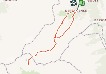
Ruta Senderismo de 16,8 km a descubrir en Vallés, Conthey, Conthey. Esta ruta ha sido propuesta por jipi2.
Descripción
Attention ne pas suivre la boucle passant par la partie raide, pas de chemin...
Retour par le même chemin qu'à l'aller
Localización
País:
Switzerland
Región :
Vallés
Departamento/provincia :
Conthey
Municipio :
Conthey
Localidad:
Unknown
Salida:(Dec)
Salida:(UTM)
362570 ; 5126814 (32T) N.
Comentarios
Excursiones cerca
![Excursión Senderismo Savièse - suuntoapp-Hiking-2024-07-15T05-56-36Z - Photo](https://media.geolcdn.com/t/375/260/3058c953-a5be-42c1-bc76-71e819ce8c45.jpg&format=jpg&maxdim=2)
![Senderismo Senderismo](https://static1.geolcdn.com/sitytour/trail-icons/101.png)
suuntoapp-Hiking-2024-07-15T05-56-36Z
Senderismo
Medio
Savièse,
Vallés,
Sion,
Switzerland
![](/images/other/stat-length.png)
15 km | 24 km-effort
5h 33min
![](https://static1.geolcdn.com/siteimages/upload/files/16400158638029165_repeat_loop_refresh_sync_direction_icon.png)
No
![Excursión Senderismo Savièse - st_koreatv08_07 - Photo](https://media.geolcdn.com/t/375/260/ext.jpg?maxdim=2&url=https%3A%2F%2Fstatic1.geolcdn.com%2Fsiteimages%2Fupload%2Ffiles%2F1553511878bg_sport_marche.png)
![Senderismo Senderismo](https://static1.geolcdn.com/sitytour/trail-icons/101.png)
st_koreatv08_07
Senderismo
Muy fácil
Savièse,
Vallés,
Sion,
Switzerland
![](/images/other/stat-length.png)
4,5 km | 8,9 km-effort
1h 37min
![](https://static1.geolcdn.com/siteimages/upload/files/16400158638029165_repeat_loop_refresh_sync_direction_icon.png)
No
![Excursión Senderismo Conthey - huetten_02 - Photo](https://media.geolcdn.com/t/375/260/ext.jpg?maxdim=2&url=https%3A%2F%2Fstatic1.geolcdn.com%2Fsiteimages%2Fupload%2Ffiles%2F1553511878bg_sport_marche.png)
![Senderismo Senderismo](https://static1.geolcdn.com/sitytour/trail-icons/101.png)
huetten_02
Senderismo
Muy fácil
Conthey,
Vallés,
Conthey,
Switzerland
![](/images/other/stat-length.png)
50 km | 102 km-effort
16h 52min
![](https://static1.geolcdn.com/siteimages/upload/files/16400158638029165_repeat_loop_refresh_sync_direction_icon.png)
Sí
![Senderismo Senderismo](https://static1.geolcdn.com/sitytour/trail-icons/101.png)
Trajet du 29.10.21
Senderismo
Muy difícil
Conthey,
Vallés,
Conthey,
Switzerland
![](/images/other/stat-length.png)
19,5 km | 38 km-effort
8h 42min
![](https://static1.geolcdn.com/siteimages/upload/files/16400158638029165_repeat_loop_refresh_sync_direction_icon.png)
Sí
![Excursión Senderismo Conthey - Martigny-Kandersteg (3) Hotel du Sanetsch - Photo](https://media.geolcdn.com/t/375/260/ext.jpg?maxdim=2&url=https%3A%2F%2Fstatic1.geolcdn.com%2Fsiteimages%2Fupload%2Ffiles%2F1553511878bg_sport_marche.png)
![Senderismo Senderismo](https://static1.geolcdn.com/sitytour/trail-icons/101.png)
Martigny-Kandersteg (3) Hotel du Sanetsch
Senderismo
Muy fácil
Conthey,
Vallés,
Conthey,
Switzerland
![](/images/other/stat-length.png)
14,8 km | 28 km-effort
6h 45min
![](https://static1.geolcdn.com/siteimages/upload/files/16400158638029165_repeat_loop_refresh_sync_direction_icon.png)
No
![Excursión Senderismo Ardon - Ardon, Einzon - Photo](https://media.geolcdn.com/t/375/260/ext.jpg?maxdim=2&url=https%3A%2F%2Fstatic1.geolcdn.com%2Fsiteimages%2Fupload%2Ffiles%2F1553511878bg_sport_marche.png)
![Senderismo Senderismo](https://static1.geolcdn.com/sitytour/trail-icons/101.png)
Ardon, Einzon
Senderismo
Muy fácil
Ardon,
Vallés,
Conthey,
Switzerland
![](/images/other/stat-length.png)
8,1 km | 21 km-effort
6h 30min
![](https://static1.geolcdn.com/siteimages/upload/files/16400158638029165_repeat_loop_refresh_sync_direction_icon.png)
Sí
![Excursión Senderismo Conthey - Derborence, Pas de Cheville - Photo](https://media.geolcdn.com/t/375/260/ext.jpg?maxdim=2&url=https%3A%2F%2Fstatic1.geolcdn.com%2Fsiteimages%2Fupload%2Ffiles%2F1553511878bg_sport_marche.png)
![Senderismo Senderismo](https://static1.geolcdn.com/sitytour/trail-icons/101.png)
Derborence, Pas de Cheville
Senderismo
Muy fácil
Conthey,
Vallés,
Conthey,
Switzerland
![](/images/other/stat-length.png)
8,8 km | 18,1 km-effort
5h 30min
![](https://static1.geolcdn.com/siteimages/upload/files/16400158638029165_repeat_loop_refresh_sync_direction_icon.png)
Sí
![Excursión Senderismo Conthey - Tour des Muverans - Photo](https://media.geolcdn.com/t/375/260/ext.jpg?maxdim=2&url=https%3A%2F%2Fstatic1.geolcdn.com%2Fsiteimages%2Fupload%2Ffiles%2F1553511878bg_sport_marche.png)
![Senderismo Senderismo](https://static1.geolcdn.com/sitytour/trail-icons/101.png)
Tour des Muverans
Senderismo
Muy fácil
Conthey,
Vallés,
Conthey,
Switzerland
![](/images/other/stat-length.png)
48 km | 101 km-effort
23h 45min
![](https://static1.geolcdn.com/siteimages/upload/files/16400158638029165_repeat_loop_refresh_sync_direction_icon.png)
Sí
![Excursión Senderismo Conthey - Derborence, Val Derbon - Photo](https://media.geolcdn.com/t/375/260/ext.jpg?maxdim=2&url=https%3A%2F%2Fstatic1.geolcdn.com%2Fsiteimages%2Fupload%2Ffiles%2F1553511878bg_sport_marche.png)
![Senderismo Senderismo](https://static1.geolcdn.com/sitytour/trail-icons/101.png)
Derborence, Val Derbon
Senderismo
Muy fácil
Conthey,
Vallés,
Conthey,
Switzerland
![](/images/other/stat-length.png)
8,9 km | 17,6 km-effort
4h 30min
![](https://static1.geolcdn.com/siteimages/upload/files/16400158638029165_repeat_loop_refresh_sync_direction_icon.png)
Sí