![](/images/other/stat-length.png)
![Excursión Senderismo Les Arcs-sur-Argens - Les Arcs - les Apiés 2 reco - Photo](https://media.geolcdn.com/t/1900/400/ext.pjpeg?maxdim=2&url=https%3A%2F%2Fstatic1.geolcdn.com%2Fsiteimages%2Fupload%2Ffiles%2F1553511878bg_sport_marche.png)
Les Arcs - les Apiés 2 reco
Sugg
Usuario
![Longitud](/images/other/stat-length.png)
![Altitud máxima](https://static1.geolcdn.com/siteimages/upload/files/1508320355ic_sort_altitude_max_24dp.png)
![Desnivel positivo](https://static1.geolcdn.com/siteimages/upload/files/1508320355ic_sort_den_pos_24dp.png)
![Km-Effort](/images/other/stat-length.png)
![Altitud mínima](https://static1.geolcdn.com/siteimages/upload/files/1508320355ic_sort_altitude_min_24dp.png)
![Desnivel negativo](https://static1.geolcdn.com/siteimages/upload/files/1508320355ic_sort_den_neg_24dp.png)
![Boucle](https://static1.geolcdn.com/siteimages/upload/files/16400158638029165_repeat_loop_refresh_sync_direction_icon.png)
![Senderismo](https://static1.geolcdn.com/sitytour/trail-icons/101.png)
4h59
Dificultad : Medio
![Escanee este código QR para abrir la excursión en la aplicación SityTrail](https://capi.geolives.com/qq0zvz2zws4bq2lad0pu/sitytour/trails/502965/qr.png?size=200)
Aplicación GPS de excursión GRATIS
A propósito
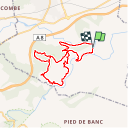
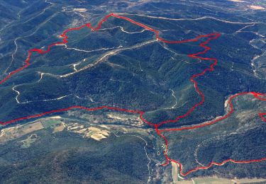
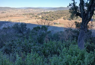
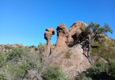
Ruta Senderismo de 17,1 km a descubrir en Provenza-Alpes-Costa Azul, Var, Les Arcs-sur-Argens. Esta ruta ha sido propuesta por Sugg.
Descripción
14-12-15, reco avec Pierre de la rando du 16-12-15.
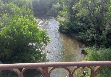
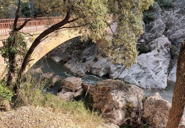
La boucle de Caillandres est intéressante ainsi que la descente sur l'Aille sous l'Apié de Raybaud qui est d'ailleurs aménagée.
Le retour au pont de l'Aille est super sympa.
Le groupe appréciera certainement.
Localización
Comentarios
Excursiones cerca
![Excursión Senderismo Les Arcs-sur-Argens - Trace_Les_Arcs - Photo](https://media.geolcdn.com/t/375/260/da020f46-e58f-416a-9a61-5f98a0302baf.jpg&format=jpg&maxdim=2)
![Senderismo Senderismo](https://static1.geolcdn.com/sitytour/trail-icons/101.png)
Senderismo
![](/images/other/stat-length.png)
![](https://static1.geolcdn.com/siteimages/upload/files/16400158638029165_repeat_loop_refresh_sync_direction_icon.png)
![Excursión Senderismo Les Arcs-sur-Argens - LES ARC SUR ARGENS-Fond du Loup-LA bergerie -DRI - Photo](https://media.geolcdn.com/t/375/260/ext.jpg?maxdim=2&url=https%3A%2F%2Fstatic1.geolcdn.com%2Fsiteimages%2Fupload%2Ffiles%2F1553511878bg_sport_marche.png)
![Senderismo Senderismo](https://static1.geolcdn.com/sitytour/trail-icons/101.png)
Senderismo
![](/images/other/stat-length.png)
![](https://static1.geolcdn.com/siteimages/upload/files/16400158638029165_repeat_loop_refresh_sync_direction_icon.png)
![Excursión Senderismo Vidauban - vidauban l'Aille - Photo](https://media.geolcdn.com/t/375/260/ext.jpg?maxdim=2&url=https%3A%2F%2Fstatic1.geolcdn.com%2Fsiteimages%2Fupload%2Ffiles%2F1553511878bg_sport_marche.png)
![Senderismo Senderismo](https://static1.geolcdn.com/sitytour/trail-icons/101.png)
Senderismo
![](/images/other/stat-length.png)
![](https://static1.geolcdn.com/siteimages/upload/files/16400158638029165_repeat_loop_refresh_sync_direction_icon.png)
![Excursión Senderismo Les Arcs-sur-Argens - La colline de Cabredor les Arcs sur Argens, 17-01-2025 - Photo](https://media.geolcdn.com/t/375/260/3f2f9c21-31ed-48da-929f-286bae1564fc.jpg&format=jpg&maxdim=2)
![Senderismo Senderismo](https://static1.geolcdn.com/sitytour/trail-icons/101.png)
Senderismo
![](/images/other/stat-length.png)
![](https://static1.geolcdn.com/siteimages/upload/files/16400158638029165_repeat_loop_refresh_sync_direction_icon.png)
![Excursión Senderismo Le Muy - Rocher de Roquebrune, Les 2 frères - Photo](https://media.geolcdn.com/t/375/260/4c3abf35-bd0e-4562-9d28-88f605def60c.jpg&format=jpg&maxdim=2)
![Senderismo Senderismo](https://static1.geolcdn.com/sitytour/trail-icons/101.png)
Senderismo
![](/images/other/stat-length.png)
![](https://static1.geolcdn.com/siteimages/upload/files/16400158638029165_repeat_loop_refresh_sync_direction_icon.png)
![Excursión Senderismo Les Arcs-sur-Argens - Les Arcs Menhirs et Dolmen - Photo](https://media.geolcdn.com/t/375/260/5cd1c0e7-b5dd-4488-ac15-1c89d37aafb6.jpg&format=jpg&maxdim=2)
![Senderismo Senderismo](https://static1.geolcdn.com/sitytour/trail-icons/101.png)
Senderismo
![](/images/other/stat-length.png)
![](https://static1.geolcdn.com/siteimages/upload/files/16400158638029165_repeat_loop_refresh_sync_direction_icon.png)
![Excursión Senderismo Les Arcs-sur-Argens - Les Arcs Menhirs et Dolmen - Photo](https://media.geolcdn.com/t/375/260/file:///storage/5427-3A6F/Android/data/com.geolives.apps.sitytrail.beta/files/ressources/captured_photos/20180713111205.jpg&format=jpg&maxdim=2)
![Senderismo Senderismo](https://static1.geolcdn.com/sitytour/trail-icons/101.png)
Senderismo
![](/images/other/stat-length.png)
![](https://static1.geolcdn.com/siteimages/upload/files/16400158638029165_repeat_loop_refresh_sync_direction_icon.png)
![Excursión Senderismo Les Arcs-sur-Argens - LES ARCS - LE MUY - LA MOTTE - SAINTE ROSELINE ET VALBOURGES - Photo](https://media.geolcdn.com/t/375/260/24a596bd-8063-44a1-bfa4-688d03d8c334.jpg&format=jpg&maxdim=2)
![Senderismo Senderismo](https://static1.geolcdn.com/sitytour/trail-icons/101.png)
Senderismo
![](/images/other/stat-length.png)
![](https://static1.geolcdn.com/siteimages/upload/files/16400158638029165_repeat_loop_refresh_sync_direction_icon.png)
![Excursión Senderismo Les Arcs-sur-Argens - sommet des Terriers, les Arcs sur Argens, 15-11-23 - Photo](https://media.geolcdn.com/t/375/260/6cb55497-4df5-448d-b641-e902de3da9ba.jpg&format=jpg&maxdim=2)
![Senderismo Senderismo](https://static1.geolcdn.com/sitytour/trail-icons/101.png)
Senderismo
![](/images/other/stat-length.png)
![](https://static1.geolcdn.com/siteimages/upload/files/16400158638029165_repeat_loop_refresh_sync_direction_icon.png)