![](/images/other/stat-length.png)
![Excursión Senderismo Notre-Dame-de-Bliquetuit - rando noel 2015 - Photo](https://media.geolcdn.com/t/1900/400/ext.pjpeg?maxdim=2&url=https%3A%2F%2Fstatic1.geolcdn.com%2Fsiteimages%2Fupload%2Ffiles%2F1553511878bg_sport_marche.png)
rando noel 2015
randojj
Usuario
![Longitud](/images/other/stat-length.png)
Longitud
8,2 km
![Altitud máxima](https://static1.geolcdn.com/siteimages/upload/files/1508320355ic_sort_altitude_max_24dp.png)
Altitud máxima
67 m
![Desnivel positivo](https://static1.geolcdn.com/siteimages/upload/files/1508320355ic_sort_den_pos_24dp.png)
Desnivel positivo
87 m
![Km-Effort](/images/other/stat-length.png)
Km-Effort
9,4 km
![Altitud mínima](https://static1.geolcdn.com/siteimages/upload/files/1508320355ic_sort_altitude_min_24dp.png)
Altitud mínima
31 m
![Desnivel negativo](https://static1.geolcdn.com/siteimages/upload/files/1508320355ic_sort_den_neg_24dp.png)
Desnivel negativo
88 m
![Boucle](https://static1.geolcdn.com/siteimages/upload/files/16400158638029165_repeat_loop_refresh_sync_direction_icon.png)
Boucle
Sí
Fecha de creación :
2019-04-26 07:45:29.269
Última modificación :
2019-04-26 07:45:29.29
![Senderismo](https://static1.geolcdn.com/sitytour/trail-icons/101.png)
2h03
Dificultad : Fácil
![Escanee este código QR para abrir la excursión en la aplicación SityTrail](https://capi.geolives.com/qq0zvz2zws4bq2lad0pu/sitytour/trails/502888/qr.png?size=200)
Aplicación GPS de excursión GRATIS
A propósito
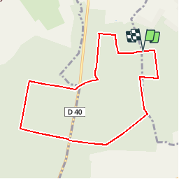
Ruta Senderismo de 8,2 km a descubrir en Normandía, Sena-Marítimo, Notre-Dame-de-Bliquetuit. Esta ruta ha sido propuesta por randojj.
Descripción
Départ Auberge le Moulin des Bruyères, foret communale de Notre Dame de Bliquetuit La pâture du mort.
Localización
País:
France
Región :
Normandía
Departamento/provincia :
Sena-Marítimo
Municipio :
Notre-Dame-de-Bliquetuit
Localidad:
Unknown
Salida:(Dec)
Salida:(UTM)
335943 ; 5484524 (31U) N.
Comentarios
Excursiones cerca
![Excursión Senderismo Rives-en-Seine - Balade à Villequier - Photo](https://media.geolcdn.com/t/375/260/ext.jpg?maxdim=2&url=https%3A%2F%2Fservices.sitytrail.com%2FGeolivesWS%2FDownloadMedia.ashx%3FTrailID%3D107143%26Media%3D11983_1.jpg)
![Senderismo Senderismo](https://static1.geolcdn.com/sitytour/trail-icons/101.png)
Balade à Villequier
Senderismo
Fácil
(1)
Rives-en-Seine,
Normandía,
Sena-Marítimo,
France
![](/images/other/stat-length.png)
9,7 km | 12,5 km-effort
2h 0min
![](https://static1.geolcdn.com/siteimages/upload/files/16400158638029165_repeat_loop_refresh_sync_direction_icon.png)
Sí
![Excursión Senderismo Notre-Dame-de-Bliquetuit - Notre Dame de Bliquetuit vers l'Armada 18km -sans photos - Photo](https://media.geolcdn.com/t/375/260/70cbc6b4-289e-4f31-9eb1-cafb40f9cb50.jpg&format=jpg&maxdim=2)
![Senderismo Senderismo](https://static1.geolcdn.com/sitytour/trail-icons/101.png)
Notre Dame de Bliquetuit vers l'Armada 18km -sans photos
Senderismo
Difícil
Notre-Dame-de-Bliquetuit,
Normandía,
Sena-Marítimo,
France
![](/images/other/stat-length.png)
18,5 km | 20 km-effort
6h 22min
![](https://static1.geolcdn.com/siteimages/upload/files/16400158638029165_repeat_loop_refresh_sync_direction_icon.png)
Sí
![Excursión Senderismo Notre-Dame-de-Bliquetuit - Notre Dame de Bliquetuit vers l'Armada 18km - Photo](https://media.geolcdn.com/t/375/260/70cbc6b4-289e-4f31-9eb1-cafb40f9cb50.jpg&format=jpg&maxdim=2)
![Senderismo Senderismo](https://static1.geolcdn.com/sitytour/trail-icons/101.png)
Notre Dame de Bliquetuit vers l'Armada 18km
Senderismo
Muy difícil
Notre-Dame-de-Bliquetuit,
Normandía,
Sena-Marítimo,
France
![](/images/other/stat-length.png)
18,5 km | 20 km-effort
4h 37min
![](https://static1.geolcdn.com/siteimages/upload/files/16400158638029165_repeat_loop_refresh_sync_direction_icon.png)
Sí
![Excursión Senderismo Notre-Dame-de-Bliquetuit - Notre Dame de Bliquetuit vers l'Armada 18km - Photo](https://media.geolcdn.com/t/375/260/70cbc6b4-289e-4f31-9eb1-cafb40f9cb50.jpg&format=jpg&maxdim=2)
![Senderismo Senderismo](https://static1.geolcdn.com/sitytour/trail-icons/101.png)
Notre Dame de Bliquetuit vers l'Armada 18km
Senderismo
Difícil
Notre-Dame-de-Bliquetuit,
Normandía,
Sena-Marítimo,
France
![](/images/other/stat-length.png)
18,5 km | 20 km-effort
6h 22min
![](https://static1.geolcdn.com/siteimages/upload/files/16400158638029165_repeat_loop_refresh_sync_direction_icon.png)
Sí
![Excursión Senderismo Rives-en-Seine - saint wandrille 76 - Photo](https://media.geolcdn.com/t/375/260/93ae6a7b-c754-44fd-a552-6b50bdaf0db6.jpg&format=jpg&maxdim=2)
![Senderismo Senderismo](https://static1.geolcdn.com/sitytour/trail-icons/101.png)
saint wandrille 76
Senderismo
Medio
Rives-en-Seine,
Normandía,
Sena-Marítimo,
France
![](/images/other/stat-length.png)
8,7 km | 11,5 km-effort
2h 41min
![](https://static1.geolcdn.com/siteimages/upload/files/16400158638029165_repeat_loop_refresh_sync_direction_icon.png)
Sí
![Senderismo Senderismo](https://static1.geolcdn.com/sitytour/trail-icons/101.png)
20220421-Caudebec en Caux Journée
Senderismo
Medio
Rives-en-Seine,
Normandía,
Sena-Marítimo,
France
![](/images/other/stat-length.png)
21 km | 27 km-effort
6h 34min
![](https://static1.geolcdn.com/siteimages/upload/files/16400158638029165_repeat_loop_refresh_sync_direction_icon.png)
Sí
![Excursión Senderismo Notre-Dame-de-Bliquetuit - Notre Dame de Bliquetuit - Photo](https://media.geolcdn.com/t/375/260/ext.jpg?maxdim=2&url=https%3A%2F%2Fservices.sitytrail.com%2FGeolivesWS%2FDownloadMedia.ashx%3FTrailID%3D1136395%26Media%3Dfix__20190418180542.jpg)
![Senderismo Senderismo](https://static1.geolcdn.com/sitytour/trail-icons/101.png)
Notre Dame de Bliquetuit
Senderismo
Muy fácil
Notre-Dame-de-Bliquetuit,
Normandía,
Sena-Marítimo,
France
![](/images/other/stat-length.png)
13,8 km | 15,5 km-effort
3h 25min
![](https://static1.geolcdn.com/siteimages/upload/files/16400158638029165_repeat_loop_refresh_sync_direction_icon.png)
Sí
![Excursión Senderismo Arelaune-en-Seine - Saint-Nicolas de Bliquetuit (Vers l'Armada) - Photo](https://media.geolcdn.com/t/375/260/ext.jpg?maxdim=2&url=https%3A%2F%2Fservices.sitytrail.com%2FGeolivesWS%2FDownloadMedia.ashx%3FTrailID%3D1136283%26Media%3Dfix__20190418123539.jpg)
![Senderismo Senderismo](https://static1.geolcdn.com/sitytour/trail-icons/101.png)
Saint-Nicolas de Bliquetuit (Vers l'Armada)
Senderismo
Muy fácil
Arelaune-en-Seine,
Normandía,
Sena-Marítimo,
France
![](/images/other/stat-length.png)
11,2 km | 12,2 km-effort
2h 32min
![](https://static1.geolcdn.com/siteimages/upload/files/16400158638029165_repeat_loop_refresh_sync_direction_icon.png)
Sí
![Excursión Senderismo Arelaune-en-Seine - La MAILLERAYE 9 km - Photo](https://media.geolcdn.com/t/375/260/ext.jpg?maxdim=2&url=https%3A%2F%2Fservices.sitytrail.com%2FGeolivesWS%2FDownloadMedia.ashx%3FTrailID%3D1133881%26Media%3Dfix__20190411160150.jpg)
![Senderismo Senderismo](https://static1.geolcdn.com/sitytour/trail-icons/101.png)
La MAILLERAYE 9 km
Senderismo
Fácil
Arelaune-en-Seine,
Normandía,
Sena-Marítimo,
France
![](/images/other/stat-length.png)
9 km | 10 km-effort
2h 7min
![](https://static1.geolcdn.com/siteimages/upload/files/16400158638029165_repeat_loop_refresh_sync_direction_icon.png)
Sí
sympathiques