![](/images/other/stat-length.png)
![Excursión Senderismo Hotton - Riveo Grottes Riveo - Photo](https://media.geolcdn.com/t/1900/400/ext.pjpeg?maxdim=2&url=https%3A%2F%2Fstatic1.geolcdn.com%2Fsiteimages%2Fupload%2Ffiles%2F1553511878bg_sport_marche.png)
Riveo Grottes Riveo
Januitcielle
Usuario
![Longitud](/images/other/stat-length.png)
Longitud
5,6 km
![Altitud máxima](https://static1.geolcdn.com/siteimages/upload/files/1508320355ic_sort_altitude_max_24dp.png)
Altitud máxima
248 m
![Desnivel positivo](https://static1.geolcdn.com/siteimages/upload/files/1508320355ic_sort_den_pos_24dp.png)
Desnivel positivo
124 m
![Km-Effort](/images/other/stat-length.png)
Km-Effort
7,2 km
![Altitud mínima](https://static1.geolcdn.com/siteimages/upload/files/1508320355ic_sort_altitude_min_24dp.png)
Altitud mínima
176 m
![Desnivel negativo](https://static1.geolcdn.com/siteimages/upload/files/1508320355ic_sort_den_neg_24dp.png)
Desnivel negativo
124 m
![Boucle](https://static1.geolcdn.com/siteimages/upload/files/16400158638029165_repeat_loop_refresh_sync_direction_icon.png)
Boucle
Sí
Fecha de creación :
2015-12-09 00:00:00.0
Última modificación :
2015-12-09 00:00:00.0
![Senderismo](https://static1.geolcdn.com/sitytour/trail-icons/101.png)
2h00
Dificultad : Medio
![Escanee este código QR para abrir la excursión en la aplicación SityTrail](https://capi.geolives.com/qq0zvz2zws4bq2lad0pu/sitytour/trails/501355/qr.png?size=200)
Aplicación GPS de excursión GRATIS
A propósito
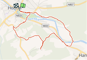
Ruta Senderismo de 5,6 km a descubrir en Valonia, Luxemburgo, Hotton. Esta ruta ha sido propuesta por Januitcielle.
Descripción
Par en dessous des falaises rocheuses et par un beau bois feuillus sur versant sud. Une très belle promenade.
Localización
País:
Belgium
Región :
Valonia
Departamento/provincia :
Luxemburgo
Municipio :
Hotton
Localidad:
Hotton
Salida:(Dec)
Salida:(UTM)
674466 ; 5571302 (31U) N.
Comentarios
Excursiones cerca
![Excursión Senderismo Hotton - RB-LUX-04 - En Famenne - Photo](https://media.geolcdn.com/t/375/260/ext.jpg?maxdim=2&url=https%3A%2F%2Fservices.sitytrail.com%2FGeolivesWS%2FDownloadMedia.ashx%3FTrailID%3D179613%26Media%3Dc1eccb03-838f-4466-b103-ba3011ffaee0.jpg)
![Senderismo Senderismo](https://static1.geolcdn.com/sitytour/trail-icons/101.png)
RB-LUX-04 - En Famenne
Senderismo
Medio
(13)
Hotton,
Valonia,
Luxemburgo,
Belgium
![](/images/other/stat-length.png)
18,4 km | 24 km-effort
5h 6min
![](https://static1.geolcdn.com/siteimages/upload/files/16400158638029165_repeat_loop_refresh_sync_direction_icon.png)
Sí
![Excursión Senderismo Hotton - RF-Lu-03 Sur la Calestienne, entre Ardenne et Famenne : Hotton - Photo](https://media.geolcdn.com/t/375/260/ext.jpg?maxdim=2&url=https%3A%2F%2Fservices.sitytrail.com%2FGeolivesWS%2FDownloadMedia.ashx%3FTrailID%3D407838%26Media%3D5ce28d25-1425-4e98-96ff-2c6c15aabb08.jpg)
![Senderismo Senderismo](https://static1.geolcdn.com/sitytour/trail-icons/101.png)
RF-Lu-03 Sur la Calestienne, entre Ardenne et Famenne : Hotton
Senderismo
Muy fácil
(3)
Hotton,
Valonia,
Luxemburgo,
Belgium
![](/images/other/stat-length.png)
11,7 km | 15,3 km-effort
3h 16min
![](https://static1.geolcdn.com/siteimages/upload/files/16400158638029165_repeat_loop_refresh_sync_direction_icon.png)
Sí
![Excursión Senderismo Rendeux - Arboretum et Ourthe - Photo](https://media.geolcdn.com/t/375/260/114fab54-a809-4035-a129-83d982caf499.jpg&format=jpg&maxdim=2)
![Senderismo Senderismo](https://static1.geolcdn.com/sitytour/trail-icons/101.png)
Arboretum et Ourthe
Senderismo
Medio
(4)
Rendeux,
Valonia,
Luxemburgo,
Belgium
![](/images/other/stat-length.png)
9 km | 12 km-effort
3h 15min
![](https://static1.geolcdn.com/siteimages/upload/files/16400158638029165_repeat_loop_refresh_sync_direction_icon.png)
Sí
![Excursión Senderismo Hotton - Fronville - Monteuville - Petihan - Photo](https://media.geolcdn.com/t/375/260/ext.jpg?maxdim=2&url=https%3A%2F%2Fservices.sitytrail.com%2FGeolivesWS%2FDownloadMedia.ashx%3FTrailID%3D1067628%26Media%3Dfix__20181106130901.jpg)
![Senderismo Senderismo](https://static1.geolcdn.com/sitytour/trail-icons/101.png)
Fronville - Monteuville - Petihan
Senderismo
Fácil
(1)
Hotton,
Valonia,
Luxemburgo,
Belgium
![](/images/other/stat-length.png)
13 km | 14,8 km-effort
2h 11min
![](https://static1.geolcdn.com/siteimages/upload/files/16400158638029165_repeat_loop_refresh_sync_direction_icon.png)
Sí
![Excursión Senderismo Hotton - Saint-Pierre - Photo](https://media.geolcdn.com/t/375/260/ext.jpg?maxdim=2&url=https%3A%2F%2Fservices.sitytrail.com%2FGeolivesWS%2FDownloadMedia.ashx%3FTrailID%3D204152%26Media%3D4d13859b-e8ea-464e-b6f5-80f7a1b7659d.jpg)
![Senderismo Senderismo](https://static1.geolcdn.com/sitytour/trail-icons/101.png)
Saint-Pierre
Senderismo
Fácil
(3)
Hotton,
Valonia,
Luxemburgo,
Belgium
![](/images/other/stat-length.png)
10,9 km | 12,1 km-effort
2h 43min
![](https://static1.geolcdn.com/siteimages/upload/files/16400158638029165_repeat_loop_refresh_sync_direction_icon.png)
Sí
![Excursión Senderismo Rendeux - promenade de lourthe - Photo](https://media.geolcdn.com/t/375/260/ext.jpg?maxdim=2&url=https%3A%2F%2Fservices.sitytrail.com%2FGeolivesWS%2FDownloadMedia.ashx%3FTrailID%3D338833%26Media%3Dfix__20140824184151.jpg)
![Senderismo Senderismo](https://static1.geolcdn.com/sitytour/trail-icons/101.png)
promenade de lourthe
Senderismo
Difícil
(3)
Rendeux,
Valonia,
Luxemburgo,
Belgium
![](/images/other/stat-length.png)
8,1 km | 11 km-effort
2h 35min
![](https://static1.geolcdn.com/siteimages/upload/files/16400158638029165_repeat_loop_refresh_sync_direction_icon.png)
Sí
![Excursión Senderismo Rendeux - Montaigu - Photo](https://media.geolcdn.com/t/375/260/ext.jpg?maxdim=2&url=https%3A%2F%2Fservices.sitytrail.com%2FGeolivesWS%2FDownloadMedia.ashx%3FTrailID%3D264121%26Media%3De6783db9-1bdf-46f4-876d-878e9e4b81fa.jpg)
![Senderismo Senderismo](https://static1.geolcdn.com/sitytour/trail-icons/101.png)
Montaigu
Senderismo
Fácil
(2)
Rendeux,
Valonia,
Luxemburgo,
Belgium
![](/images/other/stat-length.png)
5,5 km | 8 km-effort
Desconocido
![](https://static1.geolcdn.com/siteimages/upload/files/16400158638029165_repeat_loop_refresh_sync_direction_icon.png)
Sí
![Excursión Senderismo Hotton - De werpin a werpin via Trinal - Photo](https://media.geolcdn.com/t/375/260/ext.jpg?maxdim=2&url=https%3A%2F%2Fservices.sitytrail.com%2FGeolivesWS%2FDownloadMedia.ashx%3FTrailID%3D225931%26Media%3Dfix__20131007161453.jpg)
![Senderismo Senderismo](https://static1.geolcdn.com/sitytour/trail-icons/101.png)
De werpin a werpin via Trinal
Senderismo
Fácil
(1)
Hotton,
Valonia,
Luxemburgo,
Belgium
![](/images/other/stat-length.png)
9,3 km | 12,4 km-effort
2h 38min
![](https://static1.geolcdn.com/siteimages/upload/files/16400158638029165_repeat_loop_refresh_sync_direction_icon.png)
Sí