![](/images/other/stat-length.png)
![Excursión Bici de montaña Saint-Géry-Vers - Vallée du lot en partant de Vers - Photo](https://media.geolcdn.com/t/1900/400/ext.pjpeg?maxdim=2&url=https%3A%2F%2Fservices.sitytrail.com%2FGeolivesWS%2FDownloadMedia.ashx%3FTrailID%3D475009%26Media%3D90c6ca4a-2c99-4f49-99c4-64adec6ae6c1.jpg)
Vallée du lot en partant de Vers
destras
Usuario
![Longitud](/images/other/stat-length.png)
Longitud
74 km
![Altitud máxima](https://static1.geolcdn.com/siteimages/upload/files/1508320355ic_sort_altitude_max_24dp.png)
Altitud máxima
366 m
![Desnivel positivo](https://static1.geolcdn.com/siteimages/upload/files/1508320355ic_sort_den_pos_24dp.png)
Desnivel positivo
1311 m
![Km-Effort](/images/other/stat-length.png)
Km-Effort
91 km
![Altitud mínima](https://static1.geolcdn.com/siteimages/upload/files/1508320355ic_sort_altitude_min_24dp.png)
Altitud mínima
124 m
![Desnivel negativo](https://static1.geolcdn.com/siteimages/upload/files/1508320355ic_sort_den_neg_24dp.png)
Desnivel negativo
1313 m
![Boucle](https://static1.geolcdn.com/siteimages/upload/files/16400158638029165_repeat_loop_refresh_sync_direction_icon.png)
Boucle
Sí
Fecha de creación :
2016-03-09 00:00:00.0
Última modificación :
2016-03-09 00:00:00.0
![Bici de montaña](https://static1.geolcdn.com/sitytour/trail-icons/202.png)
5h49
Dificultad : Medio
![Escanee este código QR para abrir la excursión en la aplicación SityTrail](https://capi.geolives.com/qq0zvz2zws4bq2lad0pu/sitytour/trails/475009/qr.png?size=200)
Aplicación GPS de excursión GRATIS
A propósito
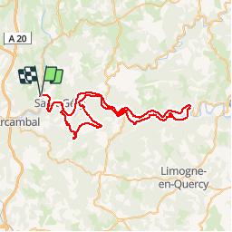
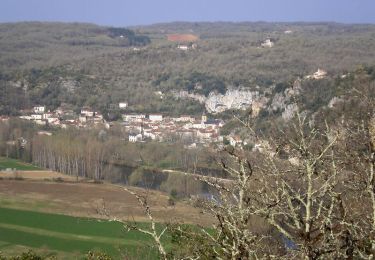
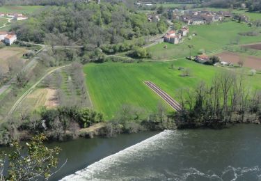
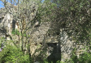
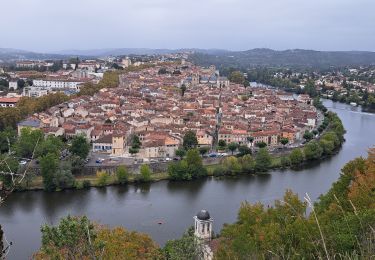
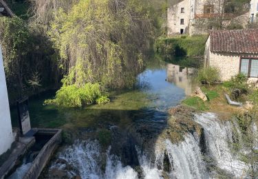
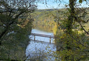
Ruta Bici de montaña de 74 km a descubrir en Occitania, Lot, Saint-Géry-Vers. Esta ruta ha sido propuesta por destras.
Descripción
La vallée du Lot en partant de Vers. Attention, il faut être en VTT pour le dernier tiers du parcours.
Localización
País:
France
Región :
Occitania
Departamento/provincia :
Lot
Municipio :
Saint-Géry-Vers
Localidad:
Unknown
Salida:(Dec)
Salida:(UTM)
384935 ; 4926852 (31T) N.
Comentarios
Excursiones cerca
![Excursión Senderismo Saint-Géry-Vers - Vers, St Gery Vallée du Lot - Photo](https://media.geolcdn.com/t/375/260/ext.jpg?maxdim=2&url=https%3A%2F%2Fservices.sitytrail.com%2FGeolivesWS%2FDownloadMedia.ashx%3FTrailID%3D103241%26Media%3D5146_6.jpg)
![Senderismo Senderismo](https://static1.geolcdn.com/sitytour/trail-icons/101.png)
Vers, St Gery Vallée du Lot
Senderismo
Difícil
(3)
Saint-Géry-Vers,
Occitania,
Lot,
France
![](/images/other/stat-length.png)
14,1 km | 19,8 km-effort
4h 0min
![](https://static1.geolcdn.com/siteimages/upload/files/16400158638029165_repeat_loop_refresh_sync_direction_icon.png)
Sí
![Senderismo Senderismo](https://static1.geolcdn.com/sitytour/trail-icons/101.png)
Causse de Vers-7539719
Senderismo
Difícil
(1)
Saint-Géry-Vers,
Occitania,
Lot,
France
![](/images/other/stat-length.png)
11,6 km | 15,9 km-effort
3h 36min
![](https://static1.geolcdn.com/siteimages/upload/files/16400158638029165_repeat_loop_refresh_sync_direction_icon.png)
Sí
![Senderismo Senderismo](https://static1.geolcdn.com/sitytour/trail-icons/101.png)
randogps46-388
Senderismo
Difícil
(1)
Aujols,
Occitania,
Lot,
France
![](/images/other/stat-length.png)
11,9 km | 16,8 km-effort
3h 49min
![](https://static1.geolcdn.com/siteimages/upload/files/16400158638029165_repeat_loop_refresh_sync_direction_icon.png)
Sí
![Excursión Senderismo Arcambal - Étape 5 Les Mazuts Cahen - Photo](https://media.geolcdn.com/t/375/260/2b1b58ea-d9da-4d3c-9ded-fdbc44ee415e.jpg&format=jpg&maxdim=2)
![Senderismo Senderismo](https://static1.geolcdn.com/sitytour/trail-icons/101.png)
Étape 5 Les Mazuts Cahen
Senderismo
Medio
Arcambal,
Occitania,
Lot,
France
![](/images/other/stat-length.png)
16,9 km | 21 km-effort
4h 40min
![](https://static1.geolcdn.com/siteimages/upload/files/16400158638029165_repeat_loop_refresh_sync_direction_icon.png)
No
![Excursión Senderismo Saint-Géry-Vers - Boucle Vers - Merlan gr46 - Photo](https://media.geolcdn.com/t/375/260/2b826dd5-3670-4ee5-a059-34afa2c2d67d.jpg&format=jpg&maxdim=2)
![Senderismo Senderismo](https://static1.geolcdn.com/sitytour/trail-icons/101.png)
Boucle Vers - Merlan gr46
Senderismo
Fácil
Saint-Géry-Vers,
Occitania,
Lot,
France
![](/images/other/stat-length.png)
14,7 km | 19,3 km-effort
4h 21min
![](https://static1.geolcdn.com/siteimages/upload/files/16400158638029165_repeat_loop_refresh_sync_direction_icon.png)
Sí
![Excursión Senderismo Arcambal - Galessie les Mazuts Barouillet - Photo](https://media.geolcdn.com/t/375/260/16327faa-cf00-4004-ade5-741b674ecd90.jpg&format=jpg&maxdim=2)
![Senderismo Senderismo](https://static1.geolcdn.com/sitytour/trail-icons/101.png)
Galessie les Mazuts Barouillet
Senderismo
Muy fácil
Arcambal,
Occitania,
Lot,
France
![](/images/other/stat-length.png)
10,7 km | 13,9 km-effort
2h 30min
![](https://static1.geolcdn.com/siteimages/upload/files/16400158638029165_repeat_loop_refresh_sync_direction_icon.png)
Sí
![Excursión Senderismo Saint-Géry-Vers - Vers merlan pech picou - Photo](https://media.geolcdn.com/t/375/260/012b6a5e-2859-438e-93b8-84dfecc2d09a.jpg&format=jpg&maxdim=2)
![Senderismo Senderismo](https://static1.geolcdn.com/sitytour/trail-icons/101.png)
Vers merlan pech picou
Senderismo
Muy fácil
Saint-Géry-Vers,
Occitania,
Lot,
France
![](/images/other/stat-length.png)
10,2 km | 13,5 km-effort
2h 13min
![](https://static1.geolcdn.com/siteimages/upload/files/16400158638029165_repeat_loop_refresh_sync_direction_icon.png)
No
![Excursión Bici eléctrica Saint-Géry-Vers - St gery St cirq Cabreret - Photo](https://media.geolcdn.com/t/375/260/d519f58f-2190-4a19-bfda-7ad5dc0cd01a.jpg&format=jpg&maxdim=2)
![Bici eléctrica Bici eléctrica](https://static1.geolcdn.com/sitytour/trail-icons/205.png)
St gery St cirq Cabreret
Bici eléctrica
Muy fácil
Saint-Géry-Vers,
Occitania,
Lot,
France
![](/images/other/stat-length.png)
39 km | 51 km-effort
3h 24min
![](https://static1.geolcdn.com/siteimages/upload/files/16400158638029165_repeat_loop_refresh_sync_direction_icon.png)
Sí
![Excursión Senderismo Saint-Géry-Vers - Moulin de Nouaillac - Photo](https://media.geolcdn.com/t/375/260/ext.jpg?maxdim=2&url=https%3A%2F%2Fstatic1.geolcdn.com%2Fsiteimages%2Fupload%2Ffiles%2F1553511878bg_sport_marche.png)
![Senderismo Senderismo](https://static1.geolcdn.com/sitytour/trail-icons/101.png)
Moulin de Nouaillac
Senderismo
Medio
(1)
Saint-Géry-Vers,
Occitania,
Lot,
France
![](/images/other/stat-length.png)
13,3 km | 18,5 km-effort
4h 0min
![](https://static1.geolcdn.com/siteimages/upload/files/16400158638029165_repeat_loop_refresh_sync_direction_icon.png)
Sí