![](/images/other/stat-length.png)
![Excursión Senderismo The Municipal District of Cahir — Cashel - Cahir Scaragh Wood Trail 3 - Photo](https://media.geolcdn.com/t/1900/400/ext.pjpeg?maxdim=2&url=https%3A%2F%2Fservices.sitytrail.com%2FGeolivesWS%2FDownloadMedia.ashx%3FTrailID%3D47054%26Media%3Dimage5.jpg)
Cahir Scaragh Wood Trail 3
johnkeating
Usuario
![Longitud](/images/other/stat-length.png)
Longitud
6,4 km
![Altitud máxima](https://static1.geolcdn.com/siteimages/upload/files/1508320355ic_sort_altitude_max_24dp.png)
Altitud máxima
299 m
![Desnivel positivo](https://static1.geolcdn.com/siteimages/upload/files/1508320355ic_sort_den_pos_24dp.png)
Desnivel positivo
220 m
![Km-Effort](/images/other/stat-length.png)
Km-Effort
9,4 km
![Altitud mínima](https://static1.geolcdn.com/siteimages/upload/files/1508320355ic_sort_altitude_min_24dp.png)
Altitud mínima
99 m
![Desnivel negativo](https://static1.geolcdn.com/siteimages/upload/files/1508320355ic_sort_den_neg_24dp.png)
Desnivel negativo
225 m
![Boucle](https://static1.geolcdn.com/siteimages/upload/files/16400158638029165_repeat_loop_refresh_sync_direction_icon.png)
Boucle
Sí
Fecha de creación :
2014-12-10 00:00:00.0
Última modificación :
2014-12-10 00:00:00.0
![Senderismo](https://static1.geolcdn.com/sitytour/trail-icons/101.png)
1h35
Dificultad : Desconocido
![Escanee este código QR para abrir la excursión en la aplicación SityTrail](https://capi.geolives.com/qq0zvz2zws4bq2lad0pu/sitytour/trails/47054/qr.png?size=200)
Aplicación GPS de excursión GRATIS
A propósito
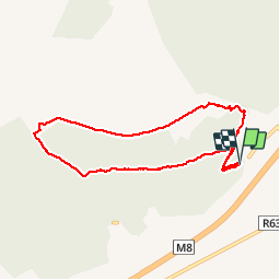
Ruta Senderismo de 6,4 km a descubrir en Desconocido, County Tipperary, The Municipal District of Cahir — Cashel. Esta ruta ha sido propuesta por johnkeating.
Descripción
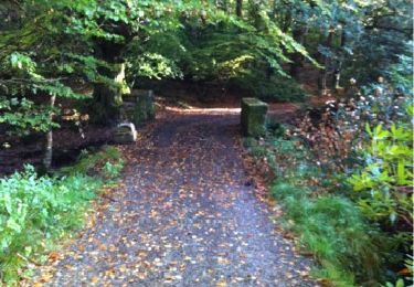
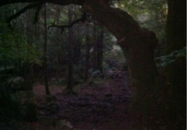
Park 50 metres from Mountain Road entrace to Scaragh Wood. Trail follows forest tracks upwards to open mountain. Remains above tree line with excellent views of Cahir, Knockmealdowns, Comeraghs and Slievnamon. Descends via forest track and small paths.
Localización
País:
Ireland
Región :
Desconocido
Departamento/provincia :
County Tipperary
Municipio :
The Municipal District of Cahir — Cashel
Localidad:
Kilcommon
Salida:(Dec)
Salida:(UTM)
570883 ; 5803432 (29U) N.
Comentarios
Excursiones cerca
![Excursión Senderismo The Municipal District of Cahir — Cashel - Cahir Scaragh Wood Trail 2 - Photo](https://media.geolcdn.com/t/375/260/ext.jpg?maxdim=2&url=https%3A%2F%2Fservices.sitytrail.com%2FGeolivesWS%2FDownloadMedia.ashx%3FTrailID%3D47228%26Media%3Dimage7.jpg)
![Senderismo Senderismo](https://static1.geolcdn.com/sitytour/trail-icons/101.png)
Cahir Scaragh Wood Trail 2
Senderismo
Muy fácil
The Municipal District of Cahir — Cashel,
Desconocido,
County Tipperary,
Ireland
![](/images/other/stat-length.png)
5,5 km | 7,4 km-effort
1h 15min
![](https://static1.geolcdn.com/siteimages/upload/files/16400158638029165_repeat_loop_refresh_sync_direction_icon.png)
Sí
![Excursión Senderismo The Municipal District of Cahir — Cashel - Cahir Scaragh Wood Trail 1 - Photo](https://media.geolcdn.com/t/375/260/ext.jpg?maxdim=2&url=https%3A%2F%2Fservices.sitytrail.com%2FGeolivesWS%2FDownloadMedia.ashx%3FTrailID%3D47126%26Media%3Dimage2.jpg)
![Senderismo Senderismo](https://static1.geolcdn.com/sitytour/trail-icons/101.png)
Cahir Scaragh Wood Trail 1
Senderismo
Muy fácil
The Municipal District of Cahir — Cashel,
Desconocido,
County Tipperary,
Ireland
![](/images/other/stat-length.png)
4,6 km | 5,9 km-effort
1h 0min
![](https://static1.geolcdn.com/siteimages/upload/files/16400158638029165_repeat_loop_refresh_sync_direction_icon.png)
Sí