![](/images/other/stat-length.png)
![Excursión Senderismo Beaumont - YHH089 Salève (depuis Beaumont) - Photo](https://media.geolcdn.com/t/1900/400/ext.pjpeg?maxdim=2&url=https%3A%2F%2Fstatic1.geolcdn.com%2Fsiteimages%2Fupload%2Ffiles%2F1553511878bg_sport_marche.png)
YHH089 Salève (depuis Beaumont)
yveshumbert
Usuario
![Longitud](/images/other/stat-length.png)
![Altitud máxima](https://static1.geolcdn.com/siteimages/upload/files/1508320355ic_sort_altitude_max_24dp.png)
![Desnivel positivo](https://static1.geolcdn.com/siteimages/upload/files/1508320355ic_sort_den_pos_24dp.png)
![Km-Effort](/images/other/stat-length.png)
![Altitud mínima](https://static1.geolcdn.com/siteimages/upload/files/1508320355ic_sort_altitude_min_24dp.png)
![Desnivel negativo](https://static1.geolcdn.com/siteimages/upload/files/1508320355ic_sort_den_neg_24dp.png)
![Boucle](https://static1.geolcdn.com/siteimages/upload/files/16400158638029165_repeat_loop_refresh_sync_direction_icon.png)
![Senderismo](https://static1.geolcdn.com/sitytour/trail-icons/101.png)
3h25
Dificultad : Difícil
![Escanee este código QR para abrir la excursión en la aplicación SityTrail](https://capi.geolives.com/qq0zvz2zws4bq2lad0pu/sitytour/trails/467677/qr.png?size=200)
Aplicación GPS de excursión GRATIS
A propósito
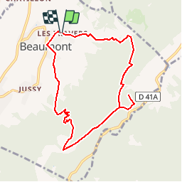
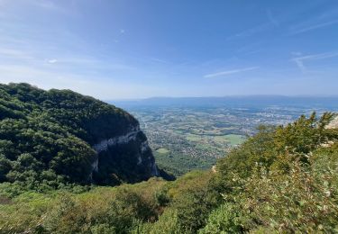
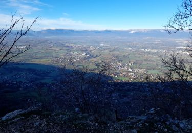
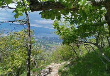
Ruta Senderismo de 8,6 km a descubrir en Auvergne-Rhône-Alpes, Alta Saboya, Beaumont. Esta ruta ha sido propuesta por yveshumbert.
Descripción
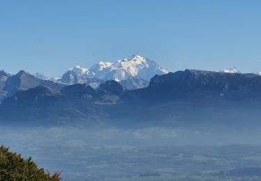
ando d' une journée en boucle au Départ de Beaumont.A Beaumont vous pouvez vous parquer à l' église ou au parking 100 mètres plus bas.La montée se fait par le chemin des petites croix pour aller au Grand Piton. La descente se fait par le chemin de la Thuile
Localización
Comentarios
Excursiones cerca
![Excursión Senderismo Présilly - 27-04-2022 Maison et Plan du Salève-Mont Sion - Photo](https://media.geolcdn.com/t/375/260/405e27da-a367-4a23-bdae-461ea923adb5.jpg&format=jpg&maxdim=2)
![Senderismo Senderismo](https://static1.geolcdn.com/sitytour/trail-icons/101.png)
Senderismo
![](/images/other/stat-length.png)
![](https://static1.geolcdn.com/siteimages/upload/files/16400158638029165_repeat_loop_refresh_sync_direction_icon.png)
![Excursión Senderismo Collonges-sous-Salève - Le Coin-Grottes d'Orjobet-La Corraterie-Grande Gorge-Le Coin - Photo](https://media.geolcdn.com/t/375/260/aabf5e02-cc0c-4aa0-939a-41b03f824e1c.jpg&format=jpg&maxdim=2)
![Senderismo Senderismo](https://static1.geolcdn.com/sitytour/trail-icons/101.png)
Senderismo
![](/images/other/stat-length.png)
![](https://static1.geolcdn.com/siteimages/upload/files/16400158638029165_repeat_loop_refresh_sync_direction_icon.png)
![Excursión Senderismo La Muraz - La Croisette - Téléphérique - Photo](https://media.geolcdn.com/t/375/260/bbb7530c-646b-4278-a608-5976a2ccf5a8.jpg&format=jpg&maxdim=2)
![Senderismo Senderismo](https://static1.geolcdn.com/sitytour/trail-icons/101.png)
Senderismo
![](/images/other/stat-length.png)
![](https://static1.geolcdn.com/siteimages/upload/files/16400158638029165_repeat_loop_refresh_sync_direction_icon.png)
![Excursión Senderismo Collonges-sous-Salève - Le Salève en boucle, orjobet , corraterie, belvédère, grande gorge - Photo](https://media.geolcdn.com/t/375/260/201bd548-abfc-4c16-8a26-ab36aa21dc20.jpg&format=jpg&maxdim=2)
![Senderismo Senderismo](https://static1.geolcdn.com/sitytour/trail-icons/101.png)
Senderismo
![](/images/other/stat-length.png)
![](https://static1.geolcdn.com/siteimages/upload/files/16400158638029165_repeat_loop_refresh_sync_direction_icon.png)
![Excursión Senderismo Collonges-sous-Salève - SALEVE - Photo](https://media.geolcdn.com/t/375/260/7cbc3f40-5ee2-427e-bcb6-ff3543321705.jpg&format=jpg&maxdim=2)
![Senderismo Senderismo](https://static1.geolcdn.com/sitytour/trail-icons/101.png)
Senderismo
![](/images/other/stat-length.png)
![](https://static1.geolcdn.com/siteimages/upload/files/16400158638029165_repeat_loop_refresh_sync_direction_icon.png)
![Excursión Senderismo Collonges-sous-Salève - GRAND SALEVE: GROTTES ET SENTIER-BALCON - Photo](https://media.geolcdn.com/t/375/260/254bcac5-a0fe-43c3-a1c2-202e25644106.jpg&format=jpg&maxdim=2)
![Senderismo Senderismo](https://static1.geolcdn.com/sitytour/trail-icons/101.png)
Senderismo
![](/images/other/stat-length.png)
![](https://static1.geolcdn.com/siteimages/upload/files/16400158638029165_repeat_loop_refresh_sync_direction_icon.png)
![Excursión Senderismo Collonges-sous-Salève - Le salave .on arrive a collonge sur saleve et on part du parking du coin - Photo](https://media.geolcdn.com/t/375/260/a3d25805-d970-493f-96be-6281e606aba7.jpg&format=jpg&maxdim=2)
![Senderismo Senderismo](https://static1.geolcdn.com/sitytour/trail-icons/101.png)
Senderismo
![](/images/other/stat-length.png)
![](https://static1.geolcdn.com/siteimages/upload/files/16400158638029165_repeat_loop_refresh_sync_direction_icon.png)
![Excursión Senderismo Collonges-sous-Salève - La Croisette - Plan du Salève - Photo](https://media.geolcdn.com/t/375/260/c6df4e05-0e87-458a-958d-100051310cc2.jpg&format=jpg&maxdim=2)
![Senderismo Senderismo](https://static1.geolcdn.com/sitytour/trail-icons/101.png)
Senderismo
![](/images/other/stat-length.png)
![](https://static1.geolcdn.com/siteimages/upload/files/16400158638029165_repeat_loop_refresh_sync_direction_icon.png)
![Excursión Senderismo Collonges-sous-Salève - Mont Salève, la grande gorge - Photo](https://media.geolcdn.com/t/375/260/f4a5a286-7b57-48d1-a03e-6798f01f2c77.jpg&format=jpg&maxdim=2)
![Senderismo Senderismo](https://static1.geolcdn.com/sitytour/trail-icons/101.png)
Senderismo
![](/images/other/stat-length.png)
![](https://static1.geolcdn.com/siteimages/upload/files/16400158638029165_repeat_loop_refresh_sync_direction_icon.png)